
Climb the mountains and get their good tidings. Nature’s peace will flow into you as the sunshine flows into trees. The winds will blow their own freshness into you, and the storms their energy, while cares will drop off like autumn leaves – John Muir, in Mountains of California, 1894.

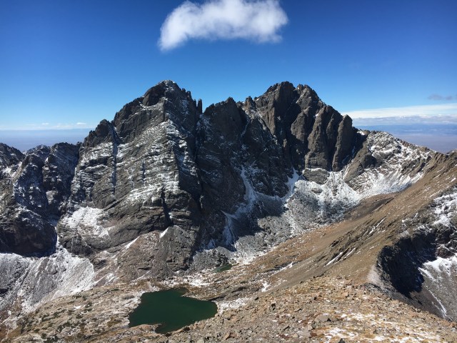
Crestone Needle towering more than 2000′ above upper South Colony Lake as seen along the trail to the summit of Humboldt Peak (photo taken 9/24/16).
One of the greatest geologic thinkers of all time was James Hutton. A scotsman that made an early career of farming and dabbled in chemisty, he developed some of the most important concepts in geosciences including deep time and the theory of uniformitarianism. The concepts were diametrically opposed to many of the societal norms of the mid-18th century; conservative religious views on the literal interpretation of the bible dictated that the Earth was only a few thousands of years old, and that the surface of the planet was shaped by catastrophes (like giant floods and earthquakes cast upon the planet to punish a sinful mankind). Towards the end of Hutton’s life he published his concepts in a short paper: Theory of the Earth; or an Investigation of the Laws observable in the Composition, Dissolution, and Restoration of Land upon the Globe (1788). In this paper he laid out some simple principles: (1) that the surface of the Earth was constantly being reworked, and the rocks must have been uplifted, eroded and buried many times over, and (2) it must have taken 10s or 100s of millions of years to make the surface of the Earth since the processes of uplift and erosion were so slow. Hutton’s clear thought on geologic processes were not unlike Einstein’s clear brake with classical mechanics – the leap in reasoning is so profound that it can only be described as genius.
Hutton found the inspiration for his theories in every rock he could find – to him they told a story of conditions, and forces, and chemistry in the distant past. I am no James Hutton, but I too, tend to look at rocks as clues to a grand “who done it”. Especially when I run or hike high in a mountain wilderness where great expanses of rock are laid bare by elevation and erosion, I am easily lost in thought about what this place must of looked like millions or billions of years ago. Many people see a imposing landscape, like the shear cliff in the photo above of Crestone Needle, and are awestruck – I am much more likely to be asking “why is it here?”. There is beauty in that shear cliff that many will miss – the base of the cliff is 1.7 billion year old granite, and the wall is a series of ancient sedimentary rocks that is composed of rocks fragments that were long ago eroded off another tall mountain that has completely disappeared from the face of the Earth.
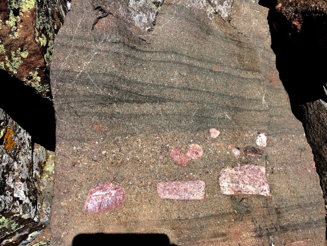
A slab of rock near the summit of Humboldt Peak – this is a sedimentary rock with layers what were deposited on the flood plain of a river draining a ancient mountain. The middle layer of the rock has large fragments deposited along the river bottom. These fragments once crowned the top of a peak, perhaps taller than even Humboldt.
I wanted to hike one more 14er in 2016 before the weather ushered in snow and ice. Although I have hiked and ran about 40 of the 14ers in Colorado, I had never visited the area around the high country of the Crestone group, home to 5 14ers in a small 2 square mile area; Crestone Needle, Crestone Peak, Kit Carson Peak, Challenger Point and Humboldt Peak. So, a late September a summit party was set for Humboldt Peak – and what was discovered was the most incredible collection of rocks that reminded me of James Hutton. A window into ancient mountains long past, a glimpse of roaring Alpine streams that must have flowed for millions of years, and a realization that the highest mountains I climb today were once beneath the surface of the sea.

Looking down the spine of the Sangre de Cristo Mountain Range from the north. The Range is narrow – only 10-12 miles wide on average – and rises some 7,000′ above flat wide valleys to the east and west. Humboldt Peak is marked in the right center part of the photograph, and is part of a cluster of 5 peaks with summit elevations above 14,000′. Photo is from PikesPeakPhoto.
Mountains are More than a Pile of Rocks
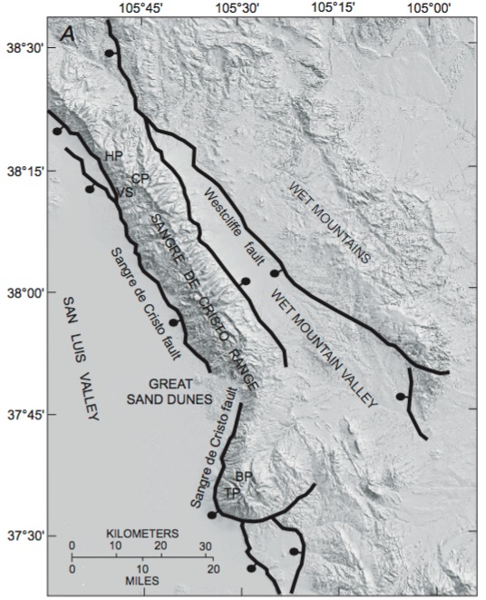
The Sangre de Cristo Range are one of the longest continuous chain of mountains in the world, and stretches from Salida, Colorado to Glorieta Pass — about 220 miles. The Sangres owe their present topography to the opening of the Rio Grande Rift. The rift, which began to “open” approximately 25 million years ago represents the latest example of extension of the southwestern lithosphere which has stretched to nearly twice its lateral extent in the last 35 million years. When the Rio Grande Rift opening it created a series of normal faults to accommodate the extension; along these normal faults mountain ranges rose as the rift floor “dropped” (in reality, the rift floor represent new continental real estate). The Sangres are the eastern margin of the rift. The northern most Sangres, which are shown in the map below, are a remarkable range. They are very narrow and very high – they almost appear to be a spine connecting Salida and Fort Garland, Colorado.
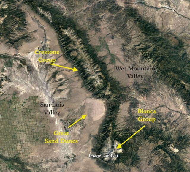
The Northern Sangre de Cristo Mountains (annotated Landsat image). The Sangres run north-south from Salida, Colorado to Glorieta Pass, New Mexico. The image above shows the northern most part of the range with separates two broad valleys (San Luis to the west and Wet Mountain to the east).
The present day Sangre de Cristo mountains are an ephemeral feature – at least as far as geology is concerned. The rocks that make up the range tell a story that is 1.7 billion years old. The majestic range today is only the latest in a long linage of great mountain ranges. The oldest rocks exposed in the northern Sangres are Precambrian in age, and were formed in island arcs where ancient oceanic plates collided; these collision resulted in subduction when one of the plates was forced back into the Earth’s mantle. This resulted in extensive melting, and fractionation of the rocks being melted. The fractionation separated some of the “lighter” materials like quartz and feldspar. These materials coalesced into large plutons – granitic bodies – that had a lower density than the oceanic plates and thus, could not be subducted. These plutons became the first continental crust. The Precambrian rocks in the Sangres were once associated with large volcanoes, and no doubt had high elevation. They were the first mountains to occupy the territory that the Sangres now reside.
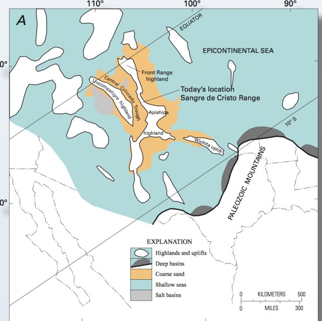
A cartoon of the land area centered on southern Colorado about 320 million years ago. The present location of the Sangre de Cristo mountain was mostly in a broad depression called the Colorado Trough. The blue shading shows the location of sea – so the Uncompahgre Uplift was a mountainous island. (figure from Lindsey, 2010).
After these mountains were formed there appears to be a long period – nearly a billion and a half years – where the dominate geologic agent in the region was erosion. Slowly, the Precambrian mountain ranges were eroded, and the sediments were washed away into ancient seas. Eventually, the seas rose and covered the ancient rocks; in the case of the northern Sangres this happened about 350 million years ago. Amazingly, there is NO rock record for the intervening time between with the Precambrian plutonic rocks and when the ocean sedimentary rocks were deposited. This is called the great unconformity, and was documented by John Wesley Powell in the Grand Canyon in the 1870s. James Hutton used a similar unconformity in Scotland to crystallize his theory of uniformitarianism.
Around 320 million years ago a large mountain block began to rise to the west of the present location of the Sangres. This mountain range, called the Uncompahgre Uplift (or simply the Ancestral Rockies), is shown in the map above. This highland was created by plate tectonic interactions, probably to the southwest. The Uncompahgre was quite high and shed detritus into streams and rivers flowing out of the mountains. Much of that erosional material was deposited in a basin called the Colorado Trough. This trough captured streams and rivers that carried silt, sands, and boulders that would become sandstones and conglomerates. The most famous of these sedimentary rocks is the Crestone Conglomerate – the locus for the deposition of the conglomerate was the area that would become the Sangres. This depositional sink could not have been far from the high country because the cobbles preserved today did not travel great distances. The second mountain range that influenced the Sangre was the Uncompahgre; and even though climbing the Sangre today does not mean passing the ancient summit, but certainly a climb up Humboldt is a shadow climb of the ancient Uncompahgre!
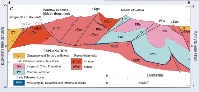
A cross section through the modern Sangre de Cristo Mountains; east to west slice, located slightly south of the Crestone group. The rock layers have been extensively shortened along thrust faults – what once was a layered cake geology is now a smashed accordion. (figure from Lindsey, 2010).
The sandstones and conglomerates that were deposited in the Colorado Trough are known as the Sangre de Cristo formation. The formation is of late Pennsylvanian and Permian age, and in places is more than 8,000 ft. thick. Once these beds were nearly horizontal, but today are often exposed as steeply dipping strata. This distortion and reconfiguration is due to a major geologic episode known as the Laramide orogeny that lasted from 80 to 40 million years before the present. Much of the crust of the western US was compressed, and the shortening was accommodated by large scale folding and thrusting. The cross section shown above is through the Sangre de Cristo range just south of the Creston Group. It can be seen that the former “layered cake” stratigraphy is now smashed together. In fact, there are many cases where older rocks overlie younger rocks.
The present high elevation of the Sangre de Cristo mountains is due to the opening of the Rio Grande Rift approximately 25 million years ago. As the crust was stretched and extended, large normal faults were formed and the mountains were uplifted on the rift margin. (figure form Lindsey, 2010).
The final major geologic episode that shaped the Sangre de Cristo range was the opening of the Rio Grande Rift, beginning about 25 million years ago. Quite simply, the continental crust of the North American plate began to be “stretched” and pulled apart. As rifting occurs lower crustal rocks melt and rise, filling the region beneath the extension. This causes uplift, and also produces large normal faults to accommodate the uplift. The margins of rifts typically have fault block mountain ranges – and that is what the Sangre de Cristo mountains are! It is not understood why the Sangres are so narrow and so high; there are 10 (or 11 depending how you count) 14ers in the Sangres, and all the 13ers in the state of New Mexico are in the Sangres.
It is tempting to look at something like the Crestone group as a eternal monument to mysterious geologic forces. However, it is remarkably temporary – we are fortunate to be living at this moment on the long strand of Earth history. But the rocks tell of mountains past, and the monument is more like a library.
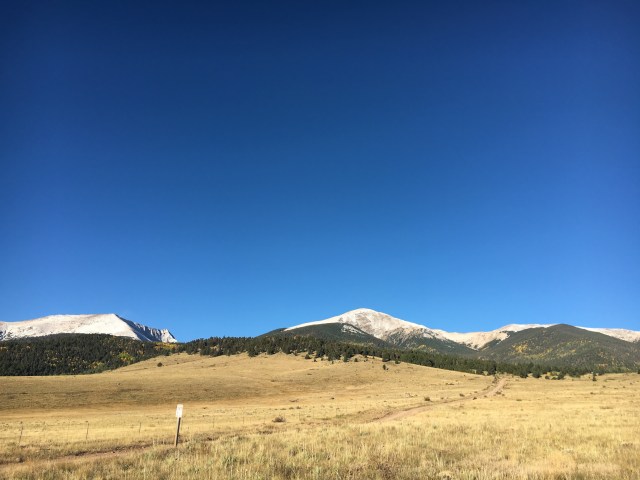
A view of Humboldt Peak (center of the photograph) from Wet Mountain Valley. The distance to the summit as a crow flies from this vantage point is about 4 miles – it is also a climb of nearly 7,000′. We drove a couple of miles to a higher trail head.
Humboldt Dreams
Picking a climb of Humboldt Peak was easy – I really wanted to visit the Crestone Group, and Humboldt is the easiest of the peaks to climb. Further, Humboldt Peak was named for a great German naturalist explorer, Alexander von Humboldt (his observations of mining practices in South America and Mexico in 1801-1804 are a classic). However, Humboldt believed in the Neptunist theory of the Earth, the exact opposite of Hutton’s thoughts (oh, the geology nexus is just too rich!). I asked my friend, and equal in terms of loving the high country, Dave Zerkle to venture to southern Colorado in late September. The weather can be “dicey” after the calendar signals that fall has started; indeed the day before we were scheduled to climb a storm blew through southern Colorado and left cold temperatures and a dusting of snow in the high country. But the passing storm also left the skies crystal clear, and views of the fall foliage were a magnetic pull to the mountains.

2.5 miles into the trek the trail enters the Sangre de Cristo Wilderness Area. The sign warns Dave Zerkle that no hang gliders are allowed. It was humorous at the time, but the high winds at the summit made the ban practical.
The trail up to the summit of Humboldt starts in the track of an old mining road, and climbs rapidly in a narrow valley towards the South Colony Lakes. These lakes are two small alpine ponds of a deep emerald color that sit in a magnificent glacial cirque surrounded by Crestone Needle, Crestone and Humboldt. The fresh snow – 1 to 2″ of very soft and dry ice crystals – is clean and without much evidence of fellow hikers. After hiking 2.5 miles the trail veers to single track and enters the Sangre de Cristo Wilderness Area. Looming to the right of the trail is the ridgeline of Humboldt, and the view to the front is dominated by the brooding escarpment of Crestone Needle.
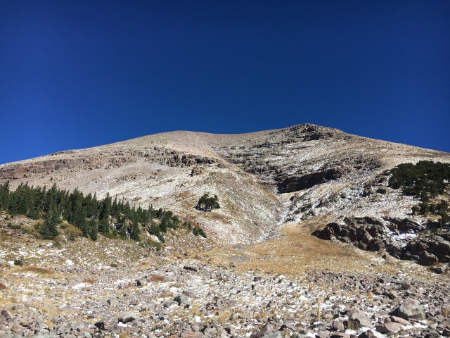
A view up the shoulder of Humboldt Peak from Colony Lakes Creek at about 11,300′ elevation.
After about 4 miles the trail passes by the South Colony Lakes; the view at the upper lake is surreal. The sky is cloudless, and an unnatural deep blue. The lake is a vibrant green, and the grey-tan rocks of Crestone Needle are highlighted by brushes of bright white snow (photograph at the top of the article). Although we have been seeing wonderful examples of Crestone Conglomerate on the way up to the alpine lakes, it is here that some truly stunning examples appear. Huge boulders that have toppled from the cirque cliffs lie scattered about. The boulders have angular clasts that vary in size from a few cm to a meter, and many have the light red color typical of a felsic granite. The size and shape of the clasts suggests that they were deposited by high energy river not far from the high ground of the Uncompahgre Uplift. The rocks look like the flood plains of the present day Arkansas River as it drains the high country of the Sawatch and Mosquito Ranges.
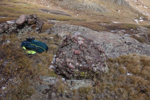
Large boulders of Crestone Conglomerate near upper South Colony Lake. Individual cobbles in the boulders are up to 50 cm in length, and are mostly composed of Precambrian granite
The elevation of the upper South Colony lake is approximately 12,000′. That means that the remaining climb to the top of Humboldt is steep – approximately 2,100′ in less than 1.75 miles. I checked my thermometer as we started up the switchbacks towards the ridgeline and it was 27 degrees F – but only moderate winds. However, with each 500′ climb the temperature drops, and the winds begin to howl. By 13,000′ the winds are uncomfortable on my face (everything thing else is covered!) – I am beginning to experience windburn, which is a strange experience unique to high mountains. The cold temperatures and high winds strip the face of oils and moisture, and the bright sun burns the skin within only a few minutes of exposure.
A view back to Crestone Needle and Crestone Peak from the ridge leading to the summit of Humboldt Peak. In the far distance the San Juan Mountains are visible.
Despite the cold and wind, the views are spectacular. I don’t really want to dawdle and take pictures because it is just too cold. The last mile of the ascent is a scramble, picking ones way through a jumble of boulders of conglomerate. After a false summit the true peak top comes into view – but the winds actually make walking difficult.
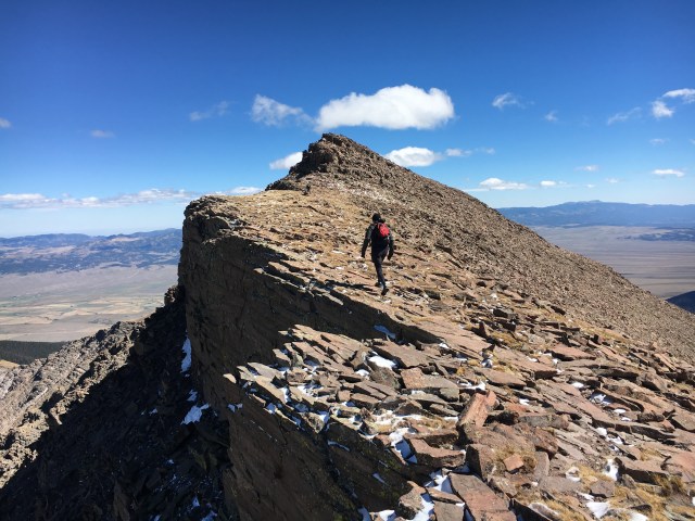
Dave Zerkle approaching the summit of Humboldt Peak. The northside of the peak is a shear cliff. Dave is crossing blocks of Sangre de Cristo Formation. In the distance is Wet Mountain Valley, some 7,000 below the summit.
The summit is broad, and in fact it is a bit difficult to tell exactly where the high point is located. But the views in all directions are breathtaking. Looking to the north you can see as far as Cottonwood Peak. To the northeast Pike’s Peak is obvious, and to the south Spanish Peaks are more than 60 miles away. My thermometer says the temperature is 21 degrees – but the wind is at least 20 miles per hour, and may be significantly higher than that. Using a wind chill calculator like NOAAs (http://www.weather.gov/epz/wxcalc_windchill) indicates that we “felt” temperatures between 0 and 6 degrees F. In these conditions the time to frost bite is minutes – and I can attest to that short time because when I took off my gloves to snap photographs I experienced a rapid freezing sensation!
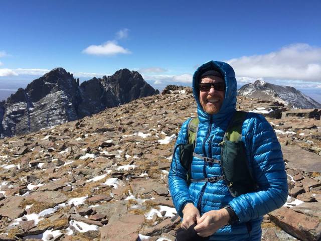
On the summit of Humboldt. Over my right shoulder is Crestone Needle and Creston Peak. Over my right shoulder is Kit Carson.
The total time we spent at the summit was only 10 minutes – a true touch and go. It was just too cold for a lingering embrace. The scramble down should be easy – except for the cold. However, my bad knee is stiff, and it takes me much longer than my climbing partner to return to the veritable tropics of South Colony Lakes.
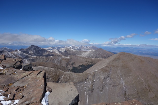
View to the north from Humboldt Peak. The tall peak in the left center is Mt. Adams which has an elevation of 13,940′. The peak in the right foreground is Colony Baldy which has an elevation of 13,711′
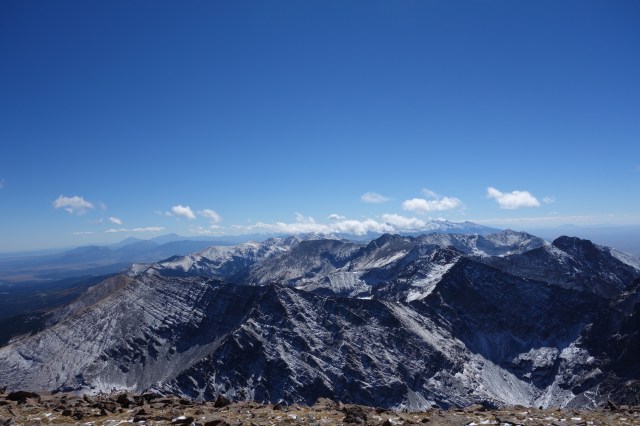
View to the south from Humboldt Peak. The peak in the foreground is Marble Mountain. In the far distance on the left side of the photo are the two humps of Spanish Peaks. The clouds partially obscure the 14ers in the Blanca group.
Despite the slow scramble descent, the rocks are really interesting. There are alternating layers of Crestone Conglomerate where the clasts are poorly sorted and of large size, and layers that almost look like sandstone. There are millions of years of erosion of the Uncompahgre Uplift locked away in the geologic section we traverse as we drop down 2000′ and return to the South Colony Lakes.
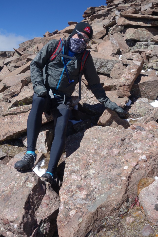
Dave Zerkle reluctantly points out a large boulder of Crestone Conglomerate at 13,500′ elevation. This boulder was part of a flood plain that had an estimated elevation of 6,000′ 250 million years ago. The flood plain eventually was buried, and the detritus was fused into the incredibly hard conglomerate. The opening of the Rio Grande Rift some 25 million years ago began a process that uplift this boulder to its present location.
Once we arrive back at the Lakes the temperature is in the upper 30s. Perfect weather for trail running, but too warm for the layered clothing that we had on for the ascent. We passed several hikers on the way back to the trail head; many were on their way to camp near the lakes and hoped to climb Crestone Needle the next day. The Needle was so impressive – it had a siren call to us also, but that will have to be another day.
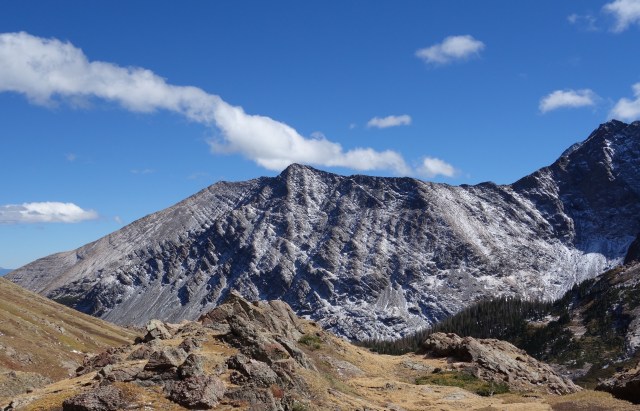
Heading down from upper South Colony Lake looking at Marble Mountain. The snow coverage accentuates the bedding of the Minim formation, sediments that are older than the Crestone conglomerate.
