Every block of stone has a statue inside it and it is the task of the sculptor to discover it — Michelangelo

One of my favorite places to visit is the Naturhistorisches Museum Wien (Natural History Museum of Vienna). As far as natural history museums go, it has to be the most important in the world. It has display space of 8,500 sq meters (about 94,000 sq ft), and it is filled with more than 30 million objects. The exhibits are decidedly old school: instead of modern interactive computer screens meant to entertain, there are taxidermy marvels documenting the discoveries of the great 18th and 19th century naturalists that explored the world as scientists. There are great fossil finds, meteorites, and stone-age works of art, and of course, there is a fantastic collection of minerals!

The museum was built to house the collections of the Habsburg Empire. The House of Habsburg ruled much of eastern Europe between the late 16th century and World War I. Emperor Franz Joseph I is credited with creating the museum in the mid-19th century, and the present building opened its doors in 1891. The core of the mineral collection is from the great mining regions that the Habsburgs controlled—Bohemia, Hungary, Austria, and what would become Romania. The oldest specimens were acquired by Archduke Ferdinand II, assembled in what is known as the “Ambrasian Collection”, and brought to Vienna in 1806.
To me, the minerals from the great Eastern European mining centers are masterpieces. Not only are they fine aesthetic specimens, but they are also artifacts that capture human history. Just as Michelangelo spoke of “releasing” the great artwork contained within a block of marble, the minerals that were collected out of the mines of Pribram, the Harz Mountains, Freiberg and Tyrol contain the stories of empires, miners, the birth of mineralogy, and the passion of collectors. Life was hard in the mines, backbreaking, dangerous work with a single goal—to produce bullion.
In Europe the rise of interest in natural sciences meant that unique specimens were preserved starting in the late 18th century. These specimens went to the collector cabinets of scientists and wealthy gentlemen. The specimens were studied and catalogued; eventually they made their way to museums or other collectors who added their labels and love, until today we have lumps of silver or gold ore that tell a human story. The tradition of collecting minerals from the mines was not passed to America until the latter part of the 19th century. The mines on the Comstock Lode on the eastern slope of the Sierra Nevada were some of the biggest silver producers ever; but they were discovered in 1859 and exhausted in about 20 years, so the number of documented specimens from the Lode is remarkably few. It is hard to imagine what mineral collections would look like today if the Comstock had been located in Bohemia.
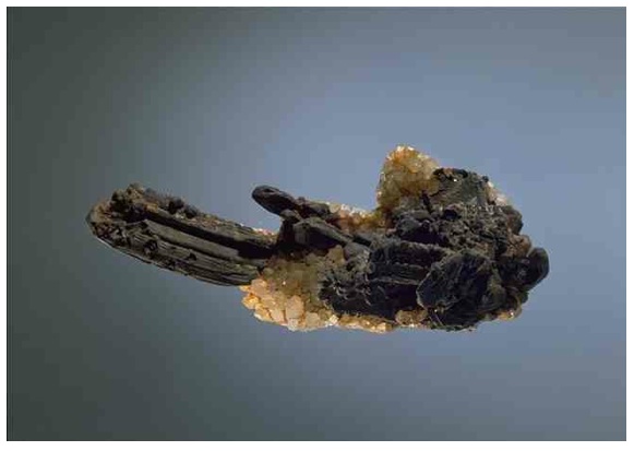
My favorite mineral in the museum is a spectacular cluster of hessite crystals, with associated quartz crystals. The specimen vaguely looks like a hand with the two fingers extended. The overall length is about 10 cm. Hessite is a silver telluride (Ag2Te) and usually is a dull gray. Hessite forms in medium or low temperature hydrothermal veins and is fairly widespread but almost never as crystals or even recognizable masses. What makes the Vienna piece so amazing is that the crystals dwarf most others in the world. The specimen is from Botes, Romania. There is a relatively small series of mines in the “Golden Quadrilateral” in Transylvania that for a few short decades produced a quantity of hessite that is unequalled in quality. In fact, Botes hessite is so outstanding compared to other localities that it is often considered a “single locality” mineral.

The northwestern quadrant of Romania is known as Transylvania, a high plateau surrounded by mountains. Upon hearing the name “Transylvania” the average person has visions of vampires and Dracula; however, to a serious mineral collector the name evokes visions of spectacular gold specimens, rare gold tellurides, and absolutely amazing hessites like the one in the Vienna Museum of Natural History. The “Golden Quadrilateral” is a region shown in the figure below that defines the largest gold resource in all of Europe. More than half of the gold ever mined in Europe came from within the 500 sq km of the Quadrilateral, and it remains the continent’s largest gold reserve. Along a north-northwest trend near the ancient town of Zlatna are a series of amazing deposits in the Apuseni Mountains. These deposits are calc-alkaline volcanic centers that are the response to the collision of Italy to Europe. The volcanoes were active between 15 and 2 million years ago. The map below shows these centers in orange, one of these is marked with a “B” which denotes a modest mountain known as Botes Hill.

Mining for gold in the Apuseni Mountains started at least 2,500 years ago. Analysis of gold artifacts found throughout the ancient world, including Troy and Egypt, indicate an origin from the Apuseni deposits. Before the Roman Empire, the region was known as Dacia; Emperor Trajan conquered the region in 106 AD. The Romans sacked the Dacian Royal Treasury and hauled off more than half a million pounds of gold and twice as much silver. Presumably, this wealth was originally mined from Apuseni. The mining center during Roman times was Ampulum, which became the modern town of Zlatna. The region bloomed again as a mining center in the 19th century when the area was under control of the Habsburgs.
The Golden Quadrilateral is rich in tellurium; in fact, the element was first described from samples of native tellurium from here in 1798. Many gold and silver tellurides were first described from here, including krennerite, nagyagite, petzite, stutzite, muthmannite and museumite. Hessite was actually first described in what is modern Kazakhstan (and named for a German chemist that described the mineral in 1829), but by far the best crystals are from Botes. There is very little written on the history of Botes. This is mainly due to the fact that it was a modest mine in terms of metal production, but in terms of hessite production it was truly remarkable!

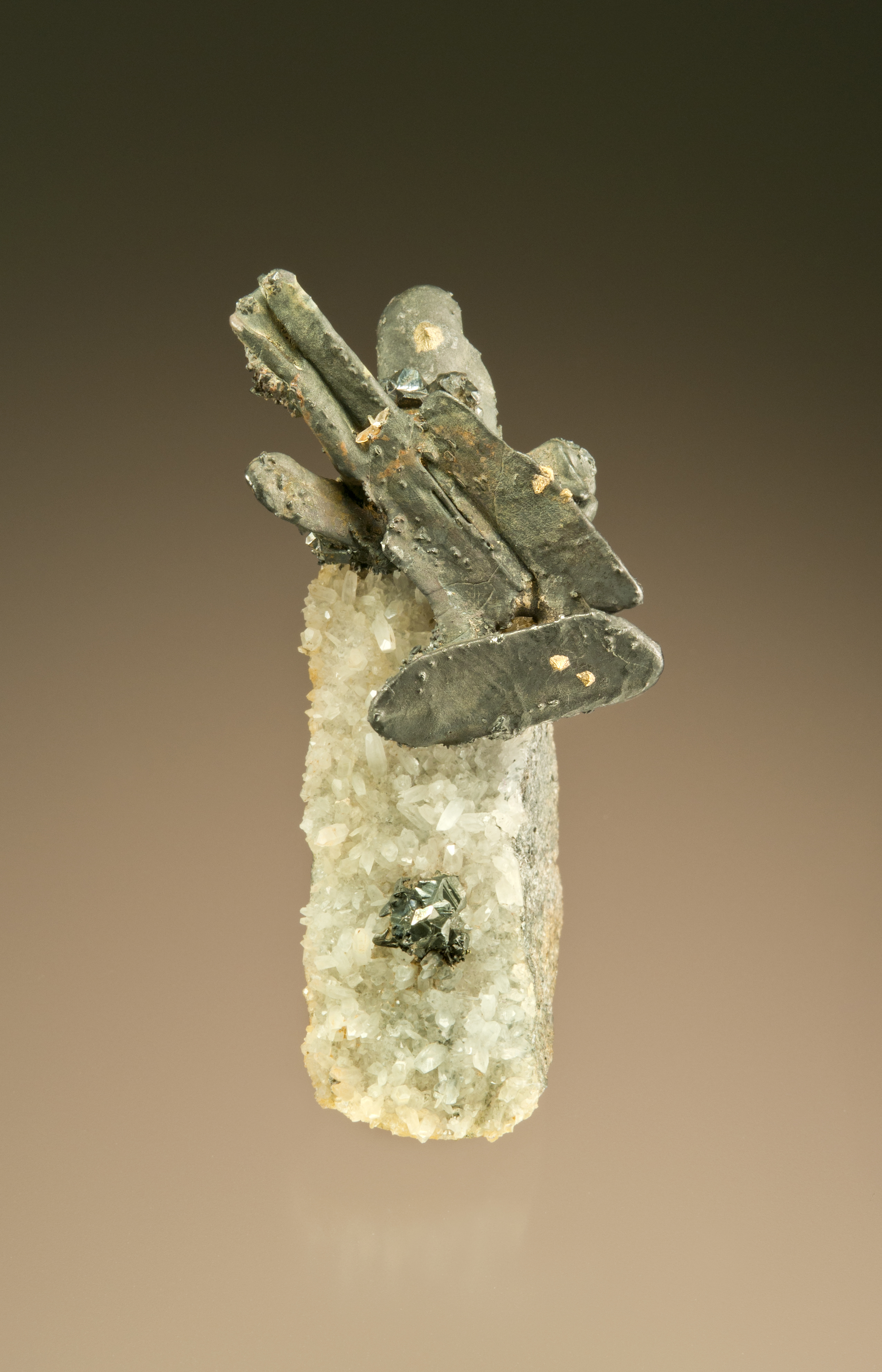
I have 5 hessites from Botes. Most are like the specimen above—a cluster of crudely cubic grey crystals on matrix with quartz (and usually a little sphalerite). To many modern collectors this specimen has limited aesthetic appeal; however, every one of these specimens has a series of old catalogue numbers and labels written by the hand of long deceased collectors. Botes only produced hessites for a relatively short period in the second half of the 19th century; all five specimens are “related”. My favorite hessite (pictured below) is a cluster of elongated crystals (the largest blade is 1.4 cm) on a sliver of matrix. The hessite crystals have blebs of gold on their surfaces. The original mineralogical explanation for this assemblage was that petzite (petzite has a formula of Ag3AuTe2, simplistically, a gold atom substituting for every fourth silver atom in hessite) was intergrown in the hessite. However, the most modern explanation is that the gold is actually intergrown directly in the hessite. Either way, the gold blebs are a unique signature.

A visit to the Vienna Museum of Natural History is a reminder to me of why I collect minerals. The minerals are magnificent recorders of past geologic events—ancient subduction zones and strata volcanoes, erosion and rearrangements of continents. At some point the veins that carried the minerals were discovered by a prospector, and eventually mined. Some nameless miner decided to collect a piece of unusual ore, which, in turn, made its way to a collector. Through the years that mineral resided in display cabinets or wooden drawers in storage racks, and may have changed hands many times. Scientists may have studied the sample and recorded the crystal structure or detailed the chemistry and postulated the theory of formation. Today that specimen—a story in stone—is in my collection, but only as a temporary resting place until to passes to the next collector.