The 10th Anniversary of the Jemez Mountain Trail Run: Surviving or thriving during a mountain ultra run

One thorn of experience is worth a whole wilderness of warning, James Russell Lowell, 19th Century American Poet

LosAlamos.morning

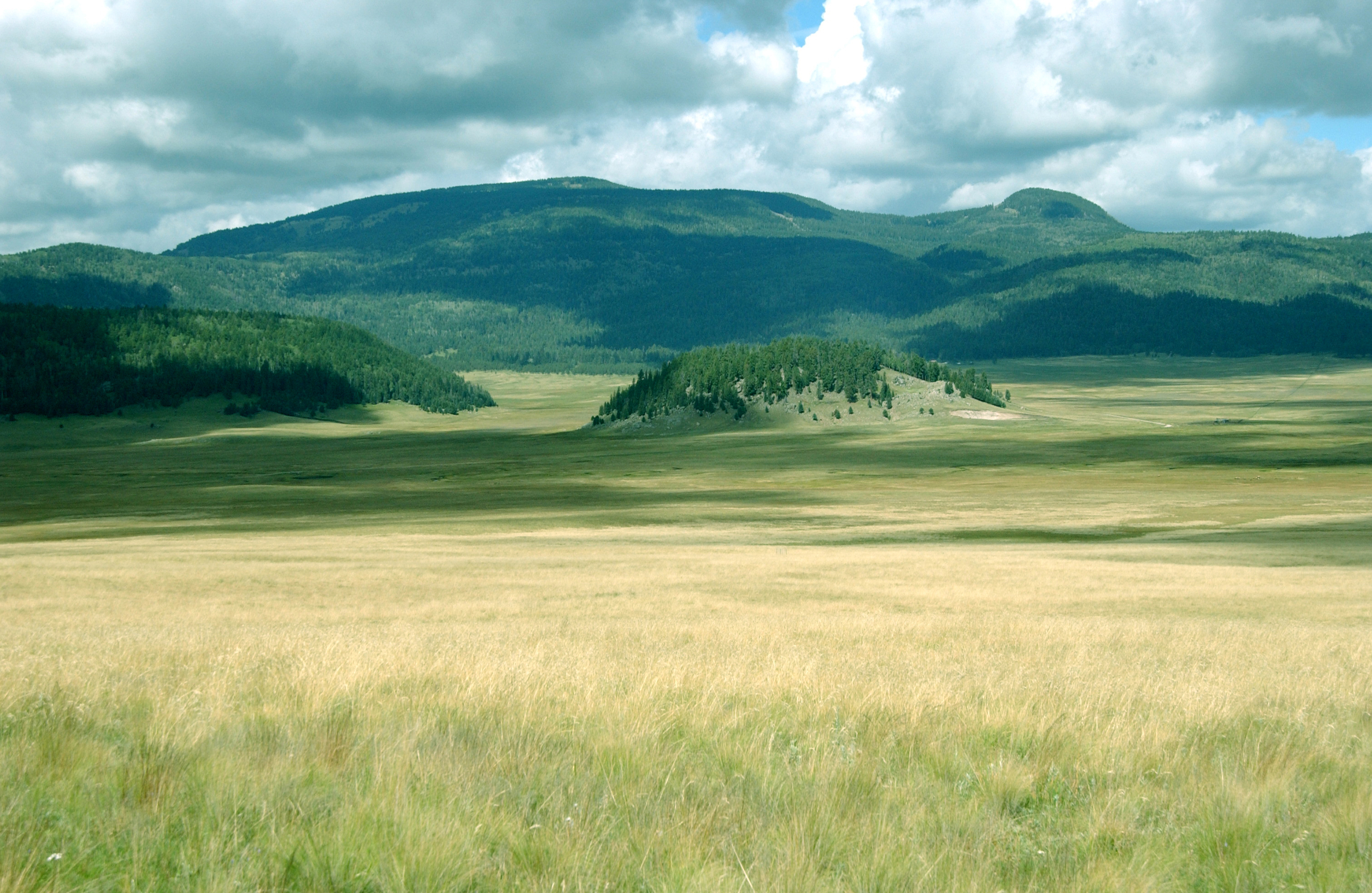
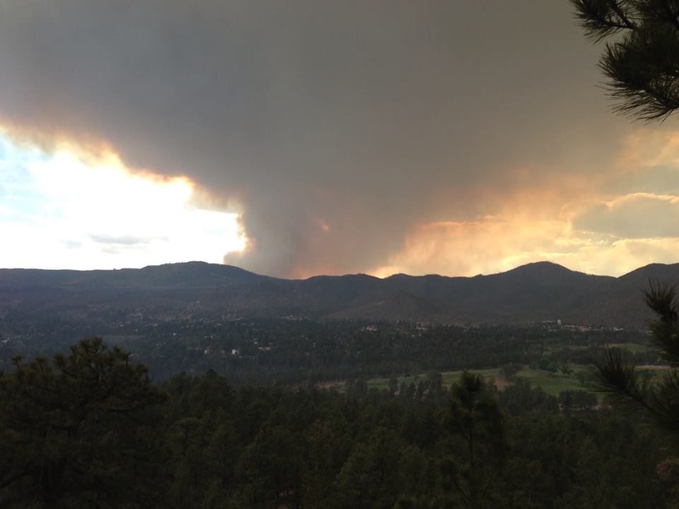
Sunrise in Los Alamos, New Mexico a few weeks before the running of the Jemez Mountain Trail Runs.

The May 23rd running of the Jemez Mountain Trail Runs marks the 10th anniversary of a wonderful group of trail runs hosted by the High Altitude Athletics Club and staffed by a most enthusiastic group of volunteers. 50 miles, 50 km, and a very “heavy” ½ marathon bring 600 runners to be challenged by steep climbs and descents traveling along the volcanic ruins of a magnificent caldera complex around Los Alamos, New Mexico. In the decade since the event was conceived as a modest local ultra event, much has changed in the world of long distance trail running; but the original goal of the JMTR – celebrating the joy of running in the mountains, is very much in evidence in Los Alamos in late May 2015.

Los Alamos has always been a unique community.  It is best known as the home of Los Alamos National Laboratory (and indeed the community would not exist without the Lab), and has a high concentration of world class scientists and engineers;  however, there are other national laboratories spread across the country, and it fair to say that in many ways the residents of Los Alamos are rather different. I grew up in Los Alamos, went away to be an academic for two decades, and had the privilege to return 13 years ago and work at the Lab.  There is a character to the town and it’s residents — lab employees or not — that embraces the rural mountain lifestyle.  People here love the outdoors and in general, they are likely to run, bike, hike, camp, hunt, swim, ski – most anything that celebrates nature.  The Jemez Mountain Trail Run is a good example of this romance.  The German website Deutsche Ultramarathon Verengung (DUV) tracks statistics for ultra trail runs, and although there is no doubt that some races are missed, it is a good measure of worldwide ultra (50 km races and beyond) participation.  In 2014, 34,954 Americans (unique names) ran in ultras.  There are 200 million adults in the US (between ages of 18 and 65);  assuming all adults could run an ultra, only .0175 percent of this population choses to do so.  The adult population of Los Alamos is approximately 12,000, which would imply that if the town was “like” the rest of the US, then about 2 of the residents would run an ultra.  In fact, in 2014, 49 Los Alamos residents ran at least one ultra — DUV and Ultrasign report that Los Alamos residents ran no less than 71 ultras, including 5 or 6 runners that entered and finished 100 mile races.  Applying bulk statistics is always fraught with danger, but it is clear that there is much Jemez love for being on the trail for long periods of time!

may21_27

Aaron Goldman, the force behind the original Jemez Mountain Trail Run in 2006. Photo from Sue Norwood, at the pre-race dinner in 2009.  Goldman passed away a short time before the 2010 JMTR.

In 2006 Aaron Goldman, a Los Alamos ultrarunner (and extraordinary humanitarian) called a friend Kristen Kern (coincidentally, the race director of the Valles Caldera Runs) and broached the idea of running a trail-based ultra.  There had always been a strong running community in the town, but access policies to land and roads adjacent to the 40 square miles of Los Alamos National Laboratory changed dramatically after 9/11.  This eventually spelled the end of long road races, and Goldman wanted to revive the racing scene on the spectacular trails in the adjacent Santa Fe National Forest.  Aaron and Kris thought about a 50 miler, a marathon and a long-distance relay race.  The marathon eventually morphed into a 50 km ultra, and the relay was dropped for logistic reasons (relay runners would actually have to travel further to their hand-off stations than they would actually run).  Goldman expected about 20 or 30 runners total – when he had an interview with the local newspaper to drum up support he stated “any weekend jogger can run our 50 mile course”.  The original race was successful beyond all hopes – about 100 runners started, although only 50 finished (apparently the non-finishers had not been jogging on weekends enough).  The next year there were two hundred runners, and the JMTR became a fixture.

Thecourse

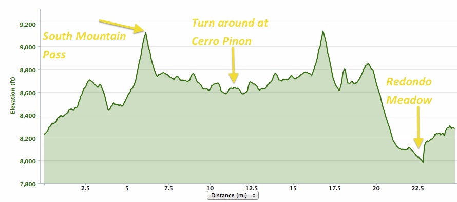
The JMTR 50k course (made in 2014, so there are minor variations in 2015). The course starts and ends at the Posse Shack, on North Mesa in Los Alamos. The low point is at mile 9 at the bottom of Los Alamos Canyon, and the high point is at mile 17 on the top of Pajarito Mountain. Click on figure to make full size.

The course for the various races has changed a number of times over the decade.  The 2011 Las Conchas fire devastated much of the high country in the eastern reaches of the Jemez Mountains, and later trail improvements by the Forest Service made for an improved pathway, but the theme has always been “a couple of long steep climbs, and spending time above 10,000 elevation”.  The run(s) are wonderful because of the courses, but the most amazing feature of the JMTR are the volunteers.  A core group of more than a dozen work year long on the event, but as the the third saturday in May approaches dozens more join in;  seems there are at least a hundred enthusiastic volunteers on race day manning the aid stations, coordinating the tracking of the runners and providing first aid, staging the best ultra party at the end, and making sure that JMTR is an ultra to remember. I am both both happy running, and proud of my community as I prepare to slog the 33 miles from the Pajarito Plateau to Pajarito Mountain, and race down Guaje Ridge.

Surviving the JMTR

I have run the JMTR 50 km several times, and I run the trails that comprise the course pretty much every week. I would not rank the course as overly difficult, although it is challenging. However, most of the people that come to run the JMTR are from outside New Mexico (Texas and Colorado are state most commonly represented), and many are from home bases that are at a much lower elevation. In addition, informal surveys of the runners indicate that 15 to 25 percent identify the JMTR as their first trail ultra. In fact, this year my wife (who is an outstanding marathoner) and two colleagues from the Washington DC area ran the JMTR as their first trail ultra.  Elites and runners that routinely race in the Rockies don’t need any advice on the JMTR.  However, there are some simple things to be aware of if you are coming from lower elevation, or are a novice distance trail runner.  The single biggest issue is attitude – the race starts at an elevation of 7280′ and has a short dip down to 7190′ in Los Alamos Canyon, and tops out at 10,440′ on Pajarito Mountain.  The average elevation during the 50k is about 9100 feet (the average is determined by time spent running the different sections of the courses – the steep, high elevation climbs take a couple of hours for most runners).

altitude550

Altitude zones, and the reduction of atmospheric pressure (and available oxygen) as a function of elevation.

The largest environmental factor limiting human performance is access to oxygen. Over the range of athletic performance (from sea level to the top of Mt. Everest) the percentage of the atmosphere that is oxygen is constant (about 20% of atmosphere is O2); however, the amount of the atmosphere decreases rapidly with elevation.  At sea level the pressure of the atmosphere by definition is 1 atm.  Climb to 8000 feet and the atmospheric pressure decreases to about 3/4 of that at sea level, and thus the available O2 decreases the same amount.  The effects of decreasing O2 pressures have been studied extensively – especially after the 1968 Mexico City Olympics. Although many world records were established in events like the high jump, NO records were recorded in “endurance” events at Mexico City.  Coincidentally, the elevation of Mexico City is nearly identical to the starting line of the JMTR.  The figure below shows a generalization of performance based on the duration of a particular event.  For all runners of the JMTR the expectation is that oxygen debt will translate to a race time that is somewhere between 15 and 25 percent slower than if the JMTR was run in Orlando, Florida.  That is a huge difference, and there is no way to “change” that value.  Arrival a day or two in Los Alamos before the JTMR will allow acclimatization so some high altitude effects (like dehydration), but it has nearly zero effect on athletic performance.  It typically takes 6 weeks to adjust endurance performance, and even then the high altitude performance will be significantly reduced from expected sea level performance.  I routinely visit Washington DC at least twice an month, and I have a standard running workout that allows me to compare this elevation effect.  I run a flat 6 miles with intervals; in Los Alamos my overall pace is about 10:20/mile, and in DC it is 9:00/mile.  No fooling mother nature!  This does not really make the JMTR “harder” than sea level ultras, just slower.  Expect slow, and accept the joy of running high.

performance

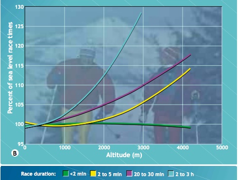
Generalized athletic performance as a function of elevation (from xxxx, 1998). Click on figure to see a larger version. Very short duration races – like the 100 m dash – benefit from the lower air pressures by reducing drag. However, long duration events – like an ultra run – see performance degradation due to lack of oxygen.

There are other effects of elevation in addition to lower oxygen pressures.  The lower atmospheric pressures mean lower water content also — relative humidity is not a great comparison between sea level and Los Alamos because it takes much less water content to saturate the high altitude atmosphere.  25% relative humidity in Los Alamos translates to the water content of a relative humidity of about 15% at sea level.  In addition, the higher elevation means lower temperatures, which additionally reduces the ability of the atmosphere to “hold” water.  It is a certainty that when you run the JMTR every expelled breath will contain much more water than the return inhaled breath.  The dry air has the advantage that sweat evaporates quickly, and it is easier to stay cool.  However, this also leads to dehydration – drink much more that you are use to!

Another effect of altitude is the intensity of UV radiation, the cause of sunburn.  The strength of UV radiation is directly proportional to the amount of atmosphere the photons pass through (UV is mostly absorbed by ozone).   The UV index is a standardized scale that relates UV intensity to “time to sunburn” for an fair-skinned person (the scale was invented in Canada, where fair skin = alabaster).  On a clear, sunny day the UV index at sea level might be a value of 8 — at 9000 feet a similar sunny day would have a UV value of 12.  The value of 12 translates to expected sunburn within 10 minutes for unprotected and exposed skin.  Sun screen is a must for the JMTR!

costofhill

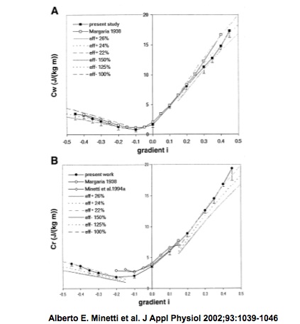
The energy cost of climbing a hill — both running and walking.

The final challenge of the JMTR is the steep climbs – and to some extent, the fast descents.  The figure above shows the energy cost for climbing a hill (the y axis is Joules per kg-minute, and x axis is the gradient, as measured in feet climbed divided by horizontal feet traveled).  The graph shows two sets of curves – one for walking (Cw) and one for running (Cr).  The biomechanics of running and walking are different, and the energy cost of running is higher – it takes twice as many calories to run a minute as it does to walk a minute.  A gradient of 20 percent (~climbing 1000 feet in a mile) takes twice as much energy as compared to running a flat course.  Between mile 13 and 17 on the JMTR the gradient is approximately 10 percent, and the energy penalty is 50%!  This will tire even seasoned runners.  Although relative penalty for walking is about the same (50%), the energy used while walking is much lower, and therefore, walking some or most of this this long ascent of Pajarito Mountain will significantly increase your energy reserve for running the last section of the JMTR.  By the way, there is a slight energy penalty associated with running downhill also due to the pounding motion on the legs.  However, this is small – the body is most efficient running down a 10% grade.

summitpajarito

I have much experience in walking the race course to the top of Pajarito Mountain – over a dozen races along this course has taught me that power walking a few miles improves my overall race time significantly. Picture from the 2014 Pajarito Trail Fest on a beautiful fall day.

All the best advice for running any ultra can only go so far.  On race day many factors – health, sleep, injuries, etc. will actually determine the outcome.  I was reminded of this lesson this year – flu like symptoms and dehydration forced me to drop the JMTR at the 18.2 mile point.  It was my first DNF in an ultra, but it was clear that my body was not in tune with my hopes!  All ultras are a struggle, and runners go through physical and mental cycles of feeling well.  Sometimes the troughs are deeper than the crests.

Trying to run the 2015 JMTR

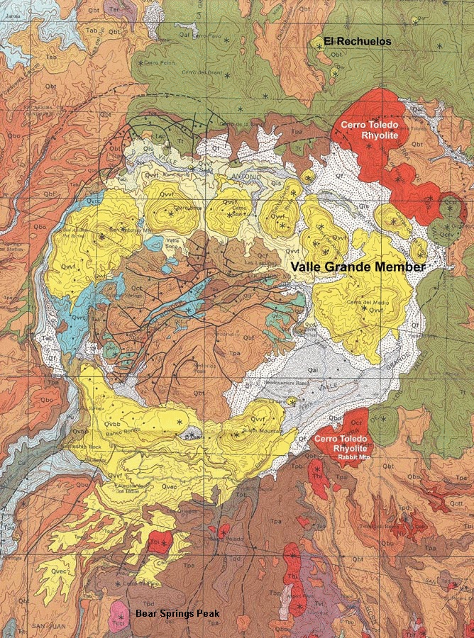
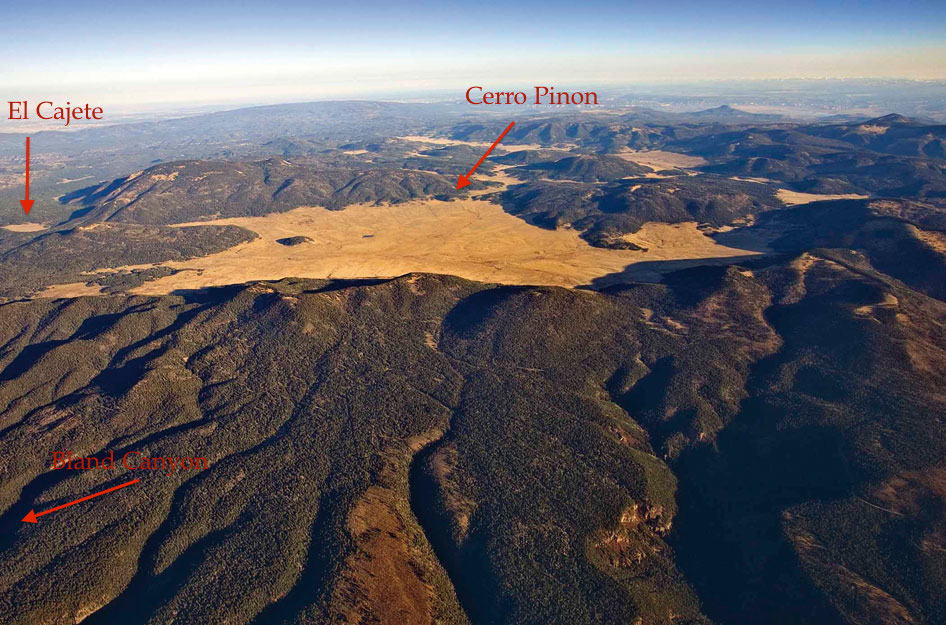
The starting and ending point for the JMTR is a historical log-cabin known as the “Posse Shack”.  The Los Alamos Sheriff’s Posse – a group of equestrian enthusiasts for the most part – built the shack as a meeting place and social center in 1958.  The Posse Shack is located on North Mesa (although many locals call it “Horse Mesa” because of the stables), one of a dozen mesas that make up the Pajarito Plateau.  The mesa is an erosional remanent and is composed of Bandelier Tuff – volcanic ash that was erupted in two mega eruptions about 1.4 million years before the present from volcanic vents that were above the Valles Caldera.  The tuff was laid down as a hot ash cloud, and “welded” by internal heat.  Despite the moniker of welded tuff, the rock is quite soft, and easily eroded.  The course takes off due east and then drops into Bayo Canyon, and runners, hikers and horse riders of the past have carved a narrow track in the tuff.

EarlyPosse

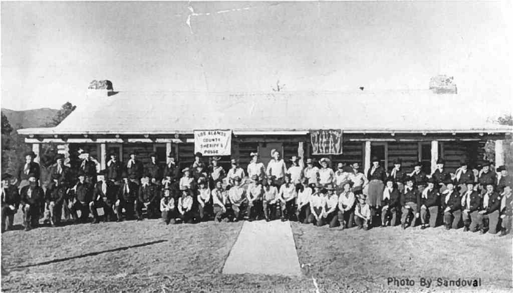
The Posse Shack, shortly after it open 57 years ago. The modest building still serves as a gathering point for events in Los Alamos.

It has been an unusual spring in Los Alamos, and for five weeks in a row before race there has been snow and rain on the town.  This moisture is most welcome even if it generated endless discussion about the consequences for the JMTR.  Last year (2014) a noon time snow squall ended up chasing a hundred runners off the course.  However, this year the weather is perfect at race time – the temperature was 47 degrees, and there was almost no chance of rain.  I awoke at 4:00 am, but had a heart rate of 41 beats per minute.  I would love to claim that this was due to extraordinary conditioning, but alas, this low heart rate means that the lack of a thyroid is “acting up”. I fixed the heart rate by downing several cups of strong coffee – got it up to 50 by race time, but knew running 50 k was going to be difficult.  2015 has been a tough year physically for me, and the latest challenge started as a toothache about 4 weeks before the JMTR.  10 days before the race it degenerated into a full blown abscess, and I awoke to a swollen face that caused one of my eyes to be shut.  The swelling was remedied by a regiment of penicillin, and after a week (3 days before the race) my face was normal, and the tooth(s) although dead did not bother me.  However, the penicillin also killed all the useful bacteria in my digestive track.  I knew that there was a chance of dehydration during the run because of digestive issues (that is a “delicate” euphemism), but prepared for the long run.

startline

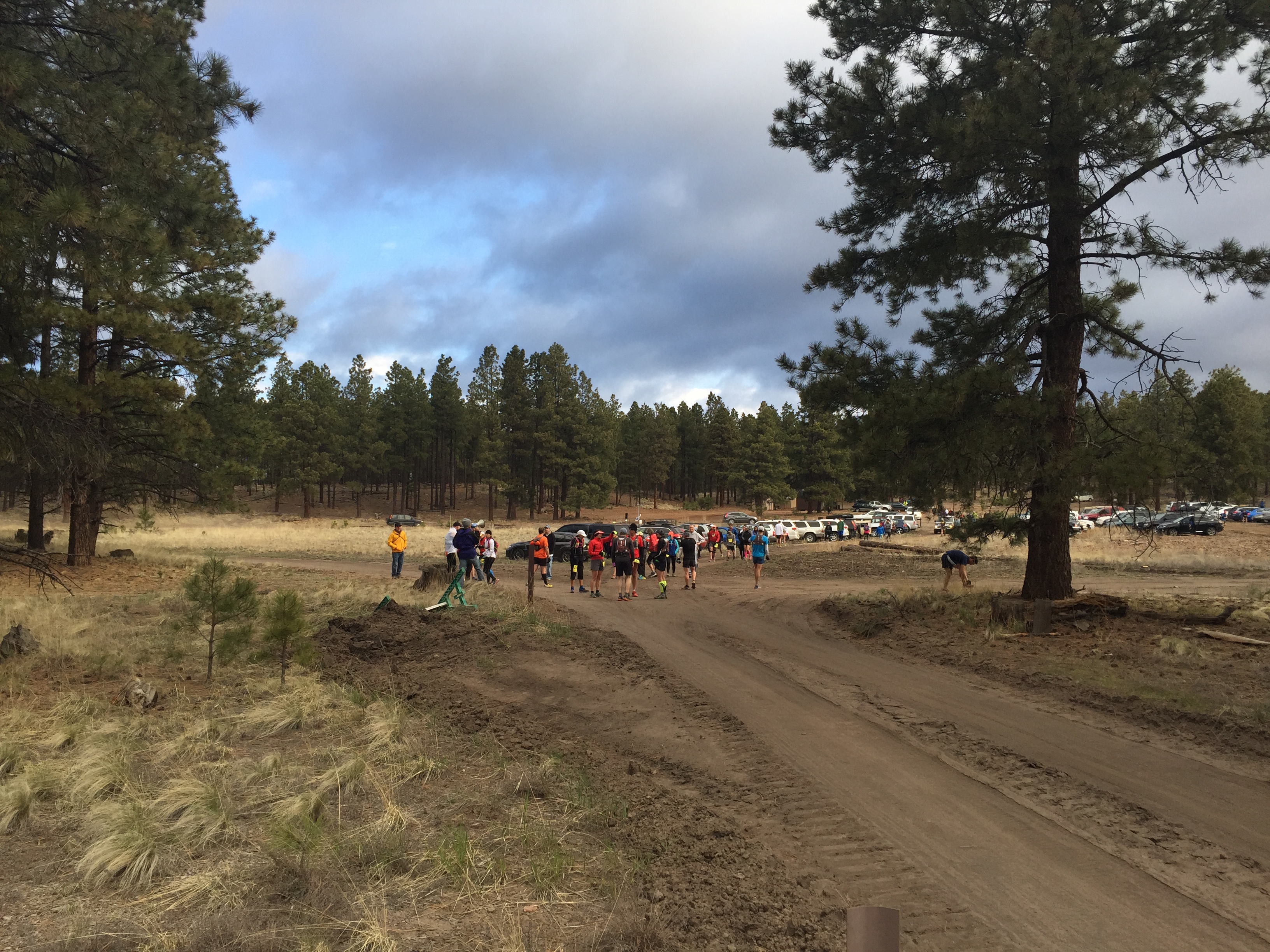
Starting line at 5:50 am, May 23, 2015. Note that the white chalk line is more like a gathering point than anything else.

The start of the 50 k is always strange.  The race director and staff are mellow, and the  “ready, set, go” is decidedly informal. However, once the start is announced the runners sprint away. Sprint!  There is 33+ miles to cover and thousands of feet to climb, but the emotion of the start catches up even the most jaded runner.  I always resist the urge to sprint – for about 10 seconds, and then I am stampeding with everyone else. As the course dips down into Bayo Canyon I always feel like a lemming that follows the pack to certain doom.

lemmings-at-the-cliff.2

The start of the 50 km race is always crazy. It very much reminds me of lemmings running as fast as they can off a cliff – no return!

The first five miles of the run is deceptively easy, and although the there is some steady climbing it is pretty easy to roll into the first aid station in under an hour.  Of course, the fastest runners have past the aid station in 45 minutes or less, so the field of runners is spread out. I arrive at the aid station at 55 minutes, but I am not feeling great.  Fortunately, for the next 10 miles or so I have great company and discuss everything from basketball to lab politics.  Mile 9 really defines the beginning of the JMTR – that is the low point elevation wise in Los Alamos Canyon.  Over the next 9 miles the climb is steady and unrelenting.  Conversation makes the miles seem pretty easy, and we arrive at Aid Station 2 (10.2 miles) about 2hrs and 15 minutes from the start.  That time is 10 minutes slower than I have ever covered on this course, but does not seem alarming yet.

Right before the aid station there is a very tough climb – short, but steep.  It is associated with the scarp of the Pajarito Fault.  The fault is related to the Rio Grande Rift and has been active (at least in a geologic sense) for at least 5 my.  The offset of the Bandelier Tuff approaching the aid station is 100m. This short climb sends alarm bells off in my head about my state of health.

dacite.geology

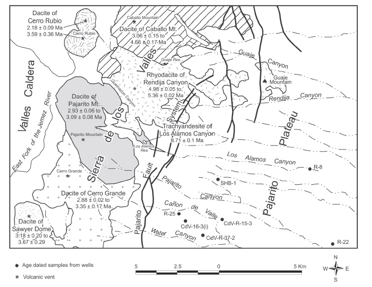
Once Aid Station 2 is passed, the trail is out of the Bandelier Tuff, and the rocks become much harder and angular.  For the next 8 miles the geology is dominated by grey dacite – there are little white flecks of plagioclase, and sometimes you can find tiny biotite crystals. Today the rocks just seemed grey. The dacite was not formed by a massive eruption, but by a series of lava flows and injections of dikes.  The map above shows the Pajarito Mountain Dacite, and the surprising location of a 3 million year old vent that extruded the dacite.  Yes, Pajarito Mountain is an ancient volcanic vent, and that vent is located just east of high point of the JMTR.

Although I am feeling punkish, we are making pretty good time on the trail.  By mile 14 we still only 10 minutes off my typical pace.  However, I have to get off the trail fast here – I urge my companions on, and by the time I am able to resume the run I am far behind.  Unfortunately, no amount of water drinking can cure the stomach maladies that now have me in their firm grip.  By the time I top out near Pajarito Mountain, I have no real control over my body.  I usually love the run from the mountain top down to the ski lodge – a drop of 1200 feet in 1.3 miles – today I am limited to a slow trot.  I make it to the ski lodge in 5 hours, but I make the very painful decision that I have to drop, and declare a “Did Not Finish”.

Only 18 miles covered on the 10th Anniversary JMTR.  Bummer.  However, the incredible volunteers at the ski lodge aid station have me pseudo hydrated soon after I drop, and arrange a ride for me back to the Posse Shack.

The JMTR was a great event despite my pitiful journey.  I was most fortunate to have a couple of guests in my home that traveled from Washington DC to race in the JMTR.  BethAnn Telford is an amazing and inspriational woman – she was diagnosed with brain cancer in the Winter of 2005 and has dedicated her life to raising awareness of the illness and constantly inspiring others that suffer from this killer.  BethAnn is an amazing runner and came out to experience the JMTR as training for a Rim-2-Rim run this October to highlight HOPE that no disease should stop the joy of life.  With BethAnn was a young woman, Sarah Domnarski, that is a running partner.  My wife ran with BethAnn and Sarah for their first ultra, and they were far more successful than I.

IMG_0368

The HOPE team at standing in front of the JMTR quilt honoring ten years of running in Los Alamos Mountains. From left, Michelle Hall, Sarah Domnarski, and BethAnn Telford.


Advertisement

Super Volcano in the Backyard: The Valles Caldera Marathon

Some things will never change. Some things will always be the same. Lean down your ear upon the earth and listen…..All things belonging to the earth will never change–the leaf, the blade, the flower, the wind that cries and sleeps and wakes again, the trees whose stiff arms clash and tremble in the dark, and the dust of lovers long since buried in the earth–all things proceeding from the earth to seasons, all things that lapse and change and come again upon the earth–these things will always be the same, for they come up from the earth that never changes, they go back into the earth that lasts forever. Only the earth endures, but it endures forever – Thomas Wolfe, in You Can’t Go Home Again (1940).

fromtheplane

Ariel view of the Valles Caldera and Jemez Mountains. This view is taken from a small plane at an elevation of 14,000′ looking south-southeast across the Valles Caldera. Photo by L. Crumple. (Click on pictures to get full sized view)

There are numerous influences in my childhood that propelled me to a career in the Earth sciences;  a father that loved to prospect and collect minerals, hundreds of family camping trips to the most interesting geologic province in the world (the Rocky Mountains!), and a progressive high school that offered a rich course in geology.  In hindsight, one of the most important influences was the fact that I grew up on the flank of a huge volcanic complex, the Jemez Mountain Volcanic Field.  The terrain of deep canyons, flat mesas, and a beautiful grass valley, the Valle Grande, surrounded by ponderosa pine covered peaks frame my childhood memories and help define home for me. The Jemez Mountains rise some 5000′ above the Rio Grande River and are remnants of a massive volcanic system that experienced two “super” eruptions about 1.4 million years ago.  The Jemez don’t really look like a volcano today if one’s idea of an active volcano is Mt. St. Helens or Kilauea – it is a large circular depression surrounded by the high peaks that once where the steep slopes of a series of craters that spewed forth hundreds of cubic km of hot ash. The figure at the top of this column is an aerial view of the Jemez, and the depression and surrounding peaks protect a series of valleys that once were filled with rain water after the great eruptions.  These valleys, or valles in spanish, are a unique feature of the Jemez. These mountains shaped me in many ways.  Out my back door was a riveting geologic panorama that provided an open invitation to explore nature.  Although most of the Valle Grande proper was off limits during my youth – it was a working cattle ranch that we just called “The Baca” in recognition that it was part of a old Land Grant called Baca Location Number 1 –  the surrounding mountains and forest lands were our play ground.

vallesgrande

View from within the Valle Grande to the west. The high peak is Redondo Peak, and the smaller rise on the righthand shoulder is Redondito Peak. The Valles Caldera marathon traverses around the base on Redondo on the edge of the Valles.

I learned about hiking, camping, wildlife, and calm call of nature.  I even learned some things about mineral collecting; in general, there is not much “mineral wise” in the Jemez, with the one exception. My first vehicle was a hand-me-down four wheel drive Toyota Land Cruiser.  Not many things worked on it (including the gas gauge which more than once left me stranded), but it did afforded me the freedom to explore the Jemez on my own.  My favorite trip was to the ghost town of Bland, a short-lived gold mining center located a few miles south of the Valles Caldera.  The mineral deposits were not formed by the volcanic processes that built the Jemez Mountains, but were from an earlier epoch of magmatic activity that injected quartz dikes into surrounding bedrock.  The Jemez volcanics covered these dikes, and later, through the randomness of erosion, were exposed in a narrow canyon (Bland Canyon).  In 1893 the first of a dozen claims was staked on these dikes for gold and silver.  A rush ensued, and soon a town was built and the population grew to more than a 1000 people.  The town was named Bland in honor of Richard Bland who had advocated for the governmental purchase of silver, and in turn, that bullion was minted into silver dollars.  The Bland act, and further requirements for the government to purchase silver (in particular, the Sherman Silver Purchase Act) were repealed in 1893 causing a collapse in silver prices — just as the mines in Bland were being discovered.

bland.1900

The boom town of Bland, circa 1900. Many of these same building were identifiable in the early 1970s when I searched for artifacts (with some success) and traces of gold or silver (without any success!). Unfortunately, all traces of Bland were destroyed in the 2011 Las Conchas fire – it is even impossible to find most of the old mine dumps.

I drove to the ghost town of Bland every chance I got in the early 1970s.  There was a “back way” in that required delicate 4WD navigation;  I was rewarded with a harrowing journey through the Jemez Mountains, and a chance to search through all the old building looking for artifacts and the mining dumps for some sign of gold or silver.  Mostly my searches were unsuccessful, but I had taste of the treasure hunter.

insulator

An insulator I collected near Bland in the early 1970s. The screw on glass has a patent date of 1893.

In the year 2000 the Federal Government purchased the “Baca” and it became the Valles Caldera Natural Preserve.  The charge of the Preserve was to remediate the effects of logging and cattle/sheep grazing, and eventually make the Valles Caldera a multi-use facility.  Although access is still carefully controlled to the Valles it has become the home to several special events.  In 2006 it became the site of a trail run – first a marathon, and later a half marathon and 10 km run were added.  The course has changed over the years, and a fire in late May of 2013 forced a change to a partial out-and-back route. The chance to run in a certified super volcano, only a few miles from my house is a huge draw – the Valles Grande Caldera Runs are a geologist’s dream.

IDL TIFF file

A recent NASA satellite image of the Valles and Jemez Mountains (click on the map to get a large, and clearer view). The circular depression of the caldera is obvious; left of the depression (east of the caldera) is Los Alamos. The brown-gray color is due to the denudation of the ponderosa pine and other vegetation after the 2000 Cerro Grande and 2011 Las Conches fires.

The volcano in my backyard

The Jemez Mountains and Valles Caldera are a spectacular sight from space. The satellite image above shows the circular depression that is about 13 miles across that formed after a series of very large eruptions of ash-flow tuffs emptied a large, shallow magma chamber.  Nearly 800 cubic km of ash were propelled from various volcanic vents, and the “hole” left by this erupting ash caused the volcanic edifice to collapsed back into itself producing a broad valley. Later, renewed magmatic activity pushed rhyolitic magmas up through the fractures formed during the collapse, producing a ring of domes breaking up the original valley into smaller, isolated valleys.  The largest of these magma extrusions, known as resurgent domes, is Redondo Peak, which has an elevation of 11,258′ and towers some 2500′ above the valley floor.  Redondo Peak is not a volcano – it was not “erupted” but extruded from the magma chamber beneath the Valles much like tooth paste would be extruded from a tube as it is slowly squeezed.

Vallea cauldera section 700

Geologic evolution of the Valles Caldera. The Valles volcanic center was active for 12 to 13 million years before a pair of major eruptions (1.5 and 1.2 million years before the present) caused the edifice of the volcanic system to collapse forming a large circular depression. Eventually this depression was dotted with a number of volcanic plugs or domes, forming the mottled landscape of Valles Caldera today (Image from the New Mexico Museum of Natural History).

The Valles Caldera remarkable symmetric, and incredibly well preserved — there were no major eruptions after the last collapse a million years ago to obscure the valley, resurgent domes and ring fractures that were formed during that collapse.  These qualities attracted geologists from around the world, and it has become the archetype volcanic caldera referenced in hundreds of studies and textbooks.  Although the Jemez Mountains were recognize being volcanic by the later part of the 19th century, it was not until the 1920s when C.S. Ross of the USGS visited, and later teamed with R.L. Smith in 1946 that the area was mapped in detail.  This mapping was done in part to understand the potential for supplying the new Los Alamos Scientific Laboratory with fresh water, and whether it was possible to bring a large natural gas line across the Valles to provide energy for my home town.  In 1970 Smith, Bailey and Ross published a beautiful geologic map of the Jemez Mountains and the Valles Caldera (figure below), and was the first map to grace the wall of my bedroom (I wish I could find that original wall hanging, but alas, it was packed away when I left for college and no doubt is today been composted and returned to the soil…).

jemez.htm_txt_smithmapjemez2

A section of the Smith, Bailey and Ross map (1970) showing the geology of the Valles Caldera. The yellow domes circling Redondo Peak (the brown color in the center of the figure) are the post collapse rhyolite resurgent domes.  The olive green color is the Bandelier Tuff – the base rock beneath Los Alamos.

The colors of the map hint at the extraordinary history of the Jemez Mountain Volcanic Field (JMVF).  The exact reason that the JMVF exists remains a bit of a mystery; it is located at the intersection of the western margin of the Rio Grande Rift and a trend of volcanic fields called the Jemez Lineament that has been postulated as a ancient “zone of weakness” that allows magma generated in the mantle to rise up into the crust.  I think that it is far more likely that the Jemez Lineament is the lucky connection of dots on a map, and that a more plausible explanation is that marks the boundary between a thick and stable crust (the Colorado Plateau) and thinner, more tectonically active crust.  Irregardless, it is clear that the opening of the Rio Grande rift caused volcanic activity to began about 13 million years ago in the vicinity of present day Los Alamos.  For about 10 million years the volcanism was dominated by basaltic lava flows.  Black Mesa, near Espanola, is one of the most famous landmarks representing this period of volcanism (Black Mesa is about 3.7 million years old).  About 3 million years ago eruption of more silica rich magmas commenced and the Jemez Mountain began to grow — there were probably 6 to 10 major volcanoes that tapped interconnected magma bodies.  These volcanoes conspired to create a major eruption about 1.5 million years ago that erupted what is known as the Otowi Member of the Bandelier Tuff.  Nearly 450 cubic kilometers of ash was erupted over a short period (probably a few years, but certainly less than a few decades).  This resulted in a collapse of the volcanic system, and the creation of the Valle Toledo Caldera.  This caldera is obscured by a similar sized eruption about 1.2 million years ago that ejected about 350 cubic kilometers of ash, the Tshirege Member of the Bandelier Tuff.  On the eastern margin of the Valle Toledo is the highest peak in the Jemez, Tschicoma Peak (elevation 11,561′), an remnant that survived both collapses.  The second eruption, and subsequent collapse created the now familiar Valles Caldera.

ashfall

Extent of ash fall from the second major Jemez Mountains Volcanic field eruption (1.2 million years ago). Ash has been identified in Kansas and Wyoming, and a large volume of the ash was transported down the Rio Grande (the blue streak in the map down the center of New Mexico).

The widely popular phrase “super volcano” has its roots in the 20th century, but mostly it is a phrase invented by the media around 2002 to dramatize the power of big volcanoes.  By 2003 the phrase appeared in more than 100 stories that covered everything from global warming and cooling to mass extinctions.  The USGS tied the phrase to the Volcano Explosivity Index (VEI), a measure of “explosiveness of eruptions”, and a VEI value of 8 became the definition of a super volcano, and implies a volume of material erupted that is at least 250 cubic km.  There have been 3 super volcanic eruptions in the US in the last 1.2 million years; the Jemez, Long Valley, California and Yellowstone in Montana/Wyoming.  All three of these eruptions resulted in the creation of a caldera.  Of course, our human centric view of geologic time — i.e, a million years is a long time — distorts the sense of “super” volcanic eruptions. Although Yellowstone was a large eruption, it was dwarfed by an eruption 28 million years ago that created the La Garita Caldera near Creede, Colorado.  Over the same time that it took the Jemez to erupt the Tshirege tuff, the La Garita erupted the Fish Canyon Tuff — all 5,000 cubic km of it (more than 15 times larger!).  Despite the size of La Garita,  Los Alamos is perched on the shoulder of a real super volcano.

VCC.copy

Comparisons of volumes of eruptions – Yellowstone and the Valles are “super volcanoes”, while more recent eruptions like Crater Lake and Krakatau have to settle for being “big” and Mt. St. Helens is just puny.

The relative tranquility of the Valles Caldera belies its violent history and magnificent history.  The most recent significant volcanic activity in the Jemez is the Banco Bonito rhyolite flow, which is located smack dab in the middle of the Jemez Caldera marathon.  The Banco Bonito is a very silica-rich rhyolite, and filled with large blocks of obsidian.  Although most everyone recognizes obsidian, and thinks arrowheads and black shiny pebbles, the geologist thinks about very rapid cooling of a volcanic rock.  Obsidian is silica glass – same material as a chunk of quartz, but it has no crystalline structure due to the rapid quenching of the hot lava. The Banco Bonito rhyolite was extruded (probably not erupted) 40,000 years ago.  Although the Jemez Mountain Volcanic Field will be active again in the future, it is mainly showing signs of exhaustion, and the likelihood of a future, large scale eruption is extremely small. Running through the Valles Caldera on a marathon is a unique experience.  Laid out along the course is every aspect of a few million years of violent tectonic history.  Ash fall, resurgent domes, ancient lake beds that filled with water in cooler and wetter times.

Vallesroute

A view from the southeast to the northwest across the Valle Grande, Redondo Peak, the the Colorado Plateau on the horizon. A little over 1/2 of the marathon course is an out-and-back from El Cajete to Cerro Pinon – right through the heart of the Valles Caldera. Also shown is the head of Bland Canyon, home of the ghost town. Picture from 2011 Nature article on Southwest drought.

The Valles Caldera Marathon

The Valles Caldera runs – there is a marathon, half marathon, and a 10 km – are not classic trail runs per se.  Most of the courses utilize dirt roads that once were used to move cattle or cut timber, and only some short segments are single track.  However, this does not diminish the spectacular setting of the race. It does mean that most people run the distances much faster than a typical trail run (I say “most” because single track versus tire rutted roads has nearly zero impact on my speed – sadly).  The races start at Banco Bonito Staging Area within Valles Caldera National Preserve.  The name “Banco Bonito” is applied to a modest plateau that is composed of the rhyolite-obsidian conglomerate that goes by the same name.  It is easy to find very attractive pieces of obsidian at the starting line — just look down.  There are more than 300 people signed up for the half marathon and 10k, but only about 45 of us toe the line for the full marathon at 7:30 in the morning.

start

Gathering of the runners for the start of the Valles Caldera marathon. Temperature at the start was 34 degrees, and throughout the day the weather alternated between sun, clouds and occasional grapple. Perfect.

The course for the marathon heads due east, climbing up the Banco Bonito lava flow along a logging road.  The lava flow is probably not obvious to most of the runners as it now is forested, and only along certain sections are there stratigraphic sections exposed.  But the topography of the lava flow is evident;  over the first three miles we climb about 450 feet (not much elevation gain, but enough to slow old runners down).  The pack of runners sorts out pretty rapidly, and good runners like Dave Coblentz disappear with a doppler shift over the horizon.  At the three mile mark the course comes to an aid station on the edge of a large bowl shaped depression — El Cajete.  This is a very significant geologic formation (but not such a significant aid station).  El Cajete is the crater that last had significant volcanic activity in the Valles Caldera.  It is responsible for the Banco Bonito lava flow 40,000 years ago, as well as a massive eruption of pumice sometime after the lava flow.  The pumice fell close to the El Cajete, and dammed the Jemez river creating a lake in the Valle Grande.

Cajete.elk

Aid station at mile 3 – looking out on El Cajete. If you click to enlarge the photo you can see a herd of elk scurrying across the crater on the right hand side — the crater is big, so the elk look small.

From El Cajete the course drops off the plateau and the run is downhill for 2 miles.  Fast and easy.  Unfortunately, the elevation lost is a penalty for the next part of the race.  At mile five there is a steep climb up a pass between Redondo Peak and another resurgent dome called South Mountain.  In a little bit more than a mile we climb 550 feet to the high point of the race, 9150′.  The top of the pass is a reward, but also a harbinger of things to come since we have to repeat this climb on the return from the Valle Grande.

profile

Course elevation profile. By my watch the course of 25.8 miles long.

From mile 6 to mile 12 the course is in the Valle Grande – well, strictly speaking, skirting around the edge of the Valle.  The grass “meadow” of the Valle Grande is due to the fact that it was a reoccurring lake bed in the last million years, and it is not particularly friendly nutrition wise to trees.  The last time the lake had a significant extent was after the El Cajete pumice eruption, and probably lasted for 4 to 7 thousand years (there have been smaller lakes during damp cool periods usually associated with glacial epochs).  The picture below is a view across the Valle towards Pajarito Mountain.  That summit, all 10,400 feet of it, is the high point of the Jemez Mountain Trail Runs — which will be run a month from now.

ValleGrande

A view across the Valle Grande to Pajarito Mountain. The weather alternated between sun and dark clouds through the entire run. The temperature was mostly in the high 40s, perfect for running a marathon.

Running through the Valle is always wonderful.  It is sensational scenery, and mostly flat topography.  At mile 9.4 I get passed by the leader of the pack returning towards the finish.  This means that the leader is about 4 miles ahead of me already.  Once the first runner passes by me it is a steady stream;  strangely, all the runners that are ahead of me look like they are strong and running very easily.  I, on the other hand, am beginning to lose focus and daydreaming of the geology.  Dave Coblentz passes me with a group of 5 or 6 runners at mile 9.7. The course “turns around” is at a point just beyond another resurgent dome — Cerro Pinon.  The milage here is just about 12 miles; there is a mental boost knowing that the “out and back” is done, but I also realize that there are 14 miles to go.  For the next 5 miles I pass by a few runners (a very few) that are slower than me, but mostly see no one.  I am alone – happy, but alone.  The climb back up the pass at South Mountain is brutal, but once that is done I am certain that I will finish the race largely unscathed.  The run down from South Mountain is fast, but as I expected, hard on my legs. The run between miles 18 and 22 is a descent of nearly 800 feet.  It should be fast, but my legs are tired.  There is a great aid station at mile 19, and I stop for way too long to eat oreo cookies.  The descent ends at a broad meadow called Redondo Meadow.  This meadow is an wildlife experiential station, and there are lots of people working in the area.  The course route is always confusing here because there is no real trail across the meadow, and there are meandering streams.  The course is marked, but that means you actually have to pay attention to the flagging (not my best skill – however, I have memorized the maps, so I don’t get detoured).  Once across the meadow the home stretch begins.  A steep climb up the Banco Bonito lava flow, and then a lonely run back to the finish.  I pass a couple of slowest runners of the 1/2 marathon, and try to encourage them (however, they are really tired).

finishline

Crossing the finish line – photo curtesy of Petra Pirc. I finish in a little over 5 1/2 hours. Long after the good runners, but happy for the experience.

I rambled into the finish line in a little over 5 1/2 hours.  It is a nice marathon – not exactly a trail run, but much harder than a street run.  The total elevation gain is about 3000 feet and the average elevation along the course is 8400′.  However, it is the geology that makes this run so great.  The Valles Caldera is truly a marvel….

The Mountains are on Fire

God has cared for these trees, saved them from drought, disease, avalanches, and a thousand tempests and floods. But he cannot save them from fools ― John Muir

Image

Smoke plume billowing above Pajarito Ski Hill (Tuesday evening, June 4; Steve Black photo)

On Friday (May 31) a downed power line started a wildfire in the west-central region of the Jemez Mountains near a deep drainage called Sulfur Creek on the western margin of Redondo Peak.  The fire burned uphill on the eastern side of the drainage rapidly, and was named the Thompson Ridge Fire (although not on Thompson Ridge).  The sight of smoke in the Jemez was visible in Los Alamos by 5 pm and the entire town held their breath, thinking “here we go again”.  By Saturday afternoon smoke from the plume began to collapse on Los Alamos, and the smell of burnt pine caused an even stronger visceral reaction triggering memories from June 2011 when the Las Conchas Fire swept around the town, led to a week-long evacuation, and charred more than 150,000 acres.  The question on many peoples’ minds is “why?”  It certainly seems that the entire Jemez is going to be soon burned, leaving a high elevation desert.  The 1996 Dome fire, the 2000 Cerro Grande and the 2011 Las Conchas Fires have changed the scenic vista of the eastern Jemez profoundly and probably for hundreds of years.  Each of these fire was bigger than the last:  The Dome fire was 16,500 acres, Cerro Grande was 48,000 acres, and Las Conchas was over 150,000 acres.  The obvious question is “are the fires getting bigger and more frequent?”

Image

The Jemez Mountains are a unique alpine island created by the Jemez Volcanic Complex (JVC) that was active for about 800,000 years beginning around 1.4 million years before the present.  The JVC lies along a line of volcanoes that arcs across New Mexico from the southwest to the northeast, known as the Jemez Lineament.  In the southwest the San Carlos Volcanic Field (in Arizona) anchors the Lineament, and it passes through Mt Taylor near Grants, the Jemez, and finally terminates in the Raton Volcanic Field.  There is no real good explanation for the Jemez Lineament, and geologists continue to debate both its cause and significance.  The JVC is the largest of the volcanic fields on the Lineament.  The geologic map above shows the Jemez Mountains.  The Jemez Mountains surround the Valles formed during the collapse of the JVC about 1.1 million years ago.  In the middle of the collapse crater a great “resurgent dome” was pushed up by the death throes of a great volcano.  This dome is Redondo Peak – which is not an eruptive volcanic cone, but an extruded dome.  Redondo Peak is the high point in the Jemez at 11,258 ft elevation.  The uniqueness of the Jemez was recognized by the first geologic expeditions of the west; John Wesley Powell himself visited the Jemez in the 1880s and described it as a giant volcanic field (anyone interested in the geology of the Jemez should read Fraser Goff’s book “Valles Caldera: A Geologic History”).

The volcanic field and Redondo rise above the surrounding New Mexico highlands to form a roughly circular mountain range.  This range has its own flora and fauna – or at least it did before the great fires of the last 25 years.  Elevations above about 7200 feet were dominated by ponderosa pine and various fir and spruce.  After a fire the pine is replaced by scrub oak and lower growing vegetation. Craig Allen has studied the fire history and vegetation of the Jemez, and has found dramatic change.

Image

This change is from both fire and mortality of the pine forest due to prolonged beetle attacks.  The figure above shows a color-coded map of the Pajarito Plateau, centered on Los Alamos, and where fire or beetles have affected our forests.  In twenty years 90% of the forest have been subject to stress.

The question of “why” is the Jemez burning can be partially answered by looking at the fire history of the mountains.  There are various ways to do this, including coring trees looking for scars from ancient fires, and looking at the peats in the meadows within the Valles and looking for preserved ash and charcoal layers.  When Allen and other researchers did this they reconstructed a fire record that stretches back nearly 10,000 years.  There are literally tens of thousands of fires over this period, and some strong trends are worth noting in the last couple of hundred years.

Image

The figure above shows the location of nearly 5000 fires in the 20th century, along with the Cerro Grande Fire.  The great bulk are small, local wildfires, probably almost always caused by lightning. There is evidence in the distant past of very large fires – probably as large as Las Conchas – all across the Jemez. There is a moderate correlation with those large fires and large-scale drought. However, before the mid-20th century wildfire was most commonly characterized by small, frequent fires.

Beginning in the late part of the 19th century man began to have a significant impact on the ecology of the Jemez.  Livestock grazing in the Jemez became “big business” and the removal of the understory grasses probably suppressed wildfire.  The cows and sheep ate the grasses that supported spreading the fires.

Image

In the 1930s the Jemez became a lumber supplier, and the region began to be heavily logged.  This is particularly true for Redondo Peak and the Valles Caldera which were in private hands, and were not subject to the regulation of the Forest Service.  The picture above shows a logging road from the mid-1930 on the northwestern side of Redondo.  Today, logging roads are still seen across the Jemez, especially as spirals up the various domes.  The lumber “boom” ended, and the forests began to fill in.  Livestock grazing dropped dramatically, and new Federal oversight of wildfire suppression caused the forest cover to densify.  By the 1960s the forests were much more dense then 200 years previous.  The pathways for fire were increasing.

Over the last 2000 years there have been periods of drought and high precipitation.  Around 1990 we entered a period of drought, and the window between 2000-2010 was likely the driest decade in a millennium.   This drought stressed the trees, and they became much more susceptible to disease.  In particular, the pine bark beetle attacked, and will eventually kill, more than 1.3 million acres of ponderosa pine in New Mexico and Northern Arizona in the period of 2002-04.  The beetle problem is complex – stressed trees are one issue, but also the density of the forest allows the beetles to spread much more rapidly than in the past.

Image

Nate McDowell and colleagues at Los Alamos produced the figure above that shows the loss of forest due to the beetles and fire.  It is fair to say we are in a long-term, profound, change of our forest.  The Jemez is not unique, but it does seem to be at the confluence of disease, drought, forest “management” and finally, the encroachment of man.  Before 1950 the vast majority of wildfire was caused by lightning.  However, since 1990 more than 85% of fires have a man-made fingerprint.  For the four major Jemez fires in the last 25 years it is all man-made;  The dome fire was caused by a camp fire, the Cerro Grande started as a controlled burn (what a total fiasco – and to this day an unpunished event), Las Conchas was started by a downed power line as was the present Thompson Ridge.

Image

Although it is dangerous to predict the fate of nature, it certainly seems that large fires are going to continue in the Jemez for years to come.  A break in the drought would help, but a short break would only promote the understory growth which would become the match stick once drought resumed.  We are standing on the cusp of a major change for our beloved Jemez, and can only hope that luck and nature conspire!