The Jemez Mountain Trail Run 2014: Dragon Weather

Blow, winds, and crack your cheeks. Rage, blow, You cataracts and hurricanoes, spout Till you have drenched our steeples, downed the cocks. William Shakespeare

Image

Near the pipeline aid station on the JMTR after the storm on May 24. Photo is from Ed Santiago who posted this on the JMTR Facebook page.

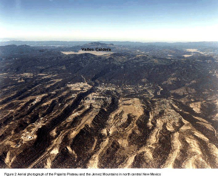
The 2014 edition of the Jemez Mountain Trail Run occurred on May 24 when the average high temperature in Los Alamos is 70 degrees and the low is 45 degrees. It rarely rains this late in May, and the expected weather for this date is “perfect”. The JMTR is a tough race in the most perfect conditions – lots of elevation gain, and the race organizers always want the runners to get their monies worth so they have “long” courses; the 50k this year was just a tiny bit less than 33 miles instead of 31.07 miles. However, a strong weather system driven by a deep southern excursion of the jet stream drove a series of rain/snow storms across Northern New Mexico on Friday and Saturday (May 23 and 24), causing “imperfect” weather for the JMTR.

Image

Jet Stream Dip, and the weather conditions for the southwest — perfect storm!

The first wave of the storm swept through Los Alamos Thursday night and continued into Friday afternoon and evening.  It dropped a about 2/3 of an inch of rain — much to the delight of the town residents that cringe at the thought of a hot, dry summer and the possibility of wildfires.  Early in the morning of race day the weather looked exceptional – mostly sunny, cool, and the rain had removed the choking dust from the trail!  There was a chance for rain in the afternoon, but that held the promise for a “cooling sprinkle” for the later stages of the 50 km and 50 mile rambles.

Image

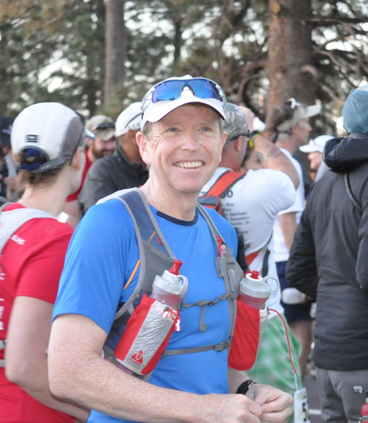
A few minutes before the start of the 50 km race at 6 am. It was cool at the Posse Shack, but the promise was for a great day! Colleagues Dave Zerkle and Eric Martens.

The 50 km race

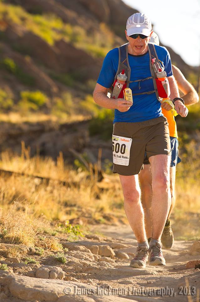
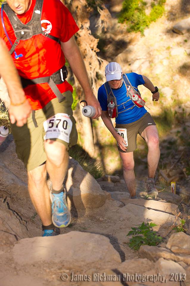
The JMTR in 2013 was hot — the temperatures in town got to a bit above 80 degrees by 2 pm, and the humidity was less than 10 percent.  Those are tough race conditions, and I lost 7 pound during the race (which is inexcusable!) due to dehydration.  So, needless to say, I was excited about the possibility of a super race with the cool temperatures this year.  I had not trained as much as I would have liked due to extensive travel for work, but I felt good.  The course for the 50 km was different this year.  The Pajarito Canyon trail was a casualty of the 2000 Cerro Grande Fire that roared across the east Jemez and Los Alamos in 2000. The fire ended up burning 48,000 acres (and 400 homes in Los Alamos), and changed the landscape of the Jemez.  Late in the fall of the 2013 the Pajarito Trail was rebuilt and provided a new pathway to climb Pajarito Mountain without trudging directly up the ski hill.

Image

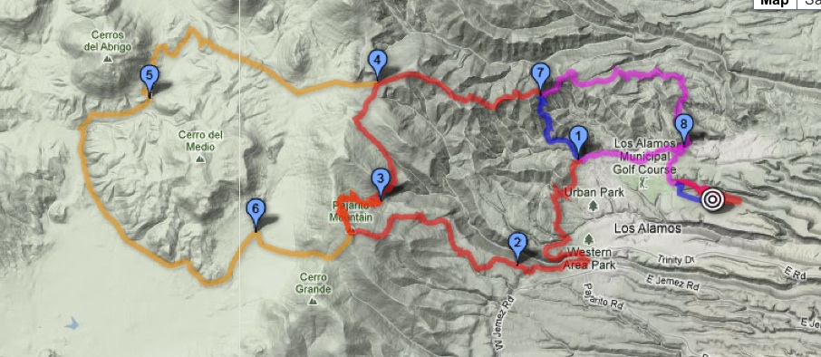
Route of the 2014 JMTR 50 km (from my Garmin, 32.97 miles, 6812 feet elevation gain). In the lower left hand side of the map is the new trail segment ascending the headwaters of Pajarito Canyon.

The race started uneventful, but delightful.  The race heads east out North Mesa before dipping in Bayo Canyon.  Typically this trail is thick with dust, but the previous days’ rains had congealed the dust into a runner’s carpet.  No clouds of dirt in the air, the first 10 miles were a runners dream.

Image

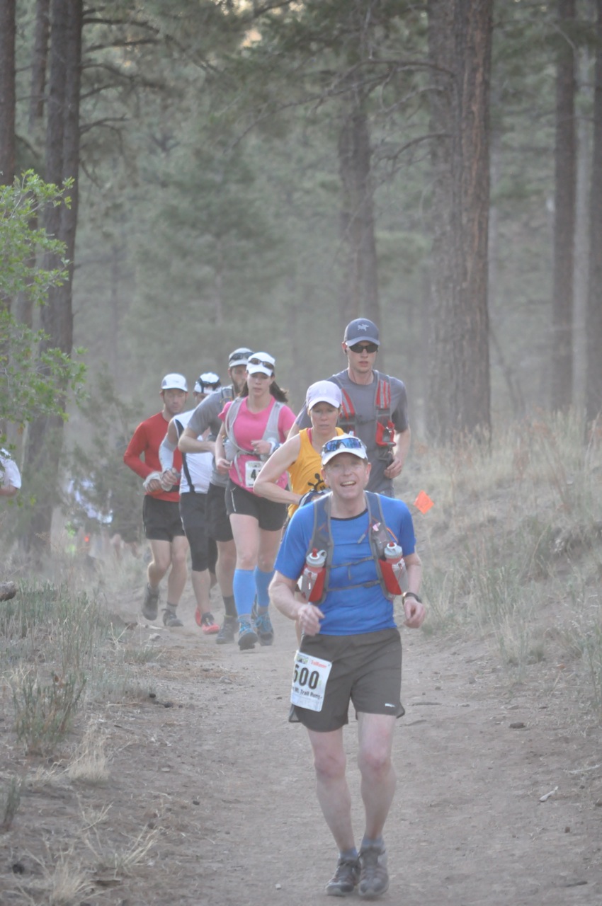
Mile 2 – wow this is fun!

Beyond the mile 10 mark and the second aid station is the climb up Pajarito Mountain.  This is 3000 feet of climbing over 7 miles.  The new segment up Pajarito Canyon is beautiful, and easier than the ski hill….but it is very long.  I chatted with many people on this section of the course, and they were wondering if the steady climb would ever end.  Once you top out at Pajarito Mountain (10,440 feet) there is a 1000 foot descent over one mile to the Pajarito Ski Hill complex and the third aid station.  I am also amazed with how slow the descent is for me – after the long climb my legs are not designed to run downhill.  I arrive about 11 am, and the sun is shining – and I feel great!

Image

Coming into the ski hill aid station. At 11 am it is a perfect day! 18.6 miles done, and mostly downhill to the end.

However, there are dark skies to west, and it is clear that some sort of storm is brewing.  The skies are far more ominous than I would have expected from the weather forecast.  I don’t really have any concerns for me finishing, but I fear for the 50 milers that will likely be caught in storm on their second ascent of Pajarito Mountain.  It looks like thunderstorms to me — and no one wants to be above tree line with lightning.  About 100 people die annually from lightning strikes (although most are golfers not runners…), and isolated high elevation ridges are much more likely to attract lightning than forested valleys.  I did not really imagine that it could snow, but in hindsight the conditions were perfect for that.  As I headed out towards aid station 4 at pipeline road the wind began to really pick up, and it was clear that some rain was on the way.

Image

The actual weather conditions for a station near my house in Los Alamos. You can see that the temperature began to plummet after noon, and the wind began to pick up. The top red line is the temperature, and it dropped from 62 degrees to 46 degrees over 3 hours. The yellow bars in the second panel show the wind speed, and the bottom panel is precipitation (aqua) and precipitation rate.

The temperature on Pajarito mountain is usually about 10 degrees cooler than in Los Alamos, due to the difference in elevation.  With a storm that has strong winds the temperature differential came be as high as 25 degrees.  As I pulled out of aid station 4 there was some rain in the air – not much, but enough to know that the storm was serious.  More importantly, the wind began to gust strongly.  At the Los Alamos weather station there were gusts that topped out just about 30 miles per hour.  It was much cooler descending the mountain down Guaje Ridge, although I attributed much of that to not working as hard as I was when I was climbing Pajarito Mountain. When you arrive at aid station 5 you are only 7 miles from the finish line.  The aid station is at an elevation of 8800 feet, and that 7 miles means a drop of 1600 feet – a runner’s delight.  However, it began to rain much harder on the descent, and I noticed that the front of my legs were bright red.  There were not many people on the trail that I could see, although I was passed by a couple runners doing the 50 miler – and they were moving!  The three people I did catch all were suffering from the weather.  I stopped and talked to one fellow that was beginning to shiver.  I was worried that he might not make it, but finally after a slow trot together I decided that he could probably get to the 6th aid station unassisted.

Around mile 30 (not yet quite at the last aid station – station 6, where they always have pie!) I was having a little trouble running, or more correctly, stumbling.  I attributed this to fatigue, but in hindsight it was the onset of mild hypothermia.  My hands were cold, but there was only a couple of miles to go.  The excitement (or, more accurately, the relief) of finishing carried me on.  Climbing up out of Bayo Canyon back to the finish line I was soaked to the core and cold – and I noticed that all the volunteers at the finish were bundled up in nice warm rain jackets.  I stumbled across the finish line, and thought I felt fine.

Image

The finish line. Cold, but I thought I was doing great!

Once inside the Posse Shack I changed out of my wet shirt into a dry shirt and coat that my wife had brought me.  I felt good, although I began to shiver.  Within 10 minutes I was shivering uncontrollably, and had some trouble controlling my hands.  At that point I realized that I had moderate hypothermia.  Hypothermia occurs when the core body temperature drops below 98.6 degrees and normal bodily functions are interrupted.  Mild hypothermia is basically shivering and what is called vasoconstriction – when blood flow is interrupted, so your finger tips turn blue and your exposed legs turn red. This interruption of blood flow causes a loss of muscle coordination, and slurred words and stumbling may happen. Recovery from mild hypothermia is not too difficult, as long as you are not exposed to the elements. Several warm cups of hot chocolate and a blanket from the EMT got me back into sorts. It seems strange that hypothermia is such a danger for runners – we are working hard, so we are producing heat.  However, it is the loss of that heat with wet conditions that lowers the CORE temperature and leads to the danger.

All in all, I enjoyed the JMTR 2014 — but I was lucky.  Many of my colleagues got stuck on the mountain as the rain began to change to snow, and the temperatures dropped to freezing.  The race director eventually stopped the race, and pulled runners off the mountain.  It had to be done.  It is a mystery of nature that weather is highly changeable, and that humans can only operate efficiently within a narrow range of conditions.  Trail running is more than distance – it is a battle with nature, the mountain, and the weather.

Advertisement

The Jemez Trail Run: A good run gone long

In every walk with Nature one receives far more than he seeks – John Muir

Image

Los Alamos is my home; I grew up in this town perched on flat mesas dissected with steep canyons cut in the volcanic tuff by a million years of rainstorms.  I loved the mountains of the Jemez and the thick forest of ponderosa pines, and I loved the town populated by special and odd people.  In the 1950s and 60s the town was “science USA”, and nearly everyone was an “outdoor buff”.  I moved when I graduated from high school in 1974, got my academic degrees, and went on to a 20 year career as a professor at the University of Arizona – but I always yearned for home. I was fortunate to have the opportunity to return a decade ago, and love my town more than ever.  It has changed – gotten lots older (people and homes), the lab is different, and the landscape has been ravaged by two horrendous fires (first in 2000, and then again in 2011 – both were the largest fires in New Mexico history at the time).  But the geology is the same – the high mountains are the rim of a super volcano that erupted and collapsed into a series of calderas during episodic activity 1.5 mya to about 600,000 years ago.  Los Alamos is built on the pale volcanic rocks that were erupted around the caldera;  these rhyolites were laid down like a snow fall building a large flat plain which we call the Pajarito Plateau today.  This Plateau has been eroded so there are a series of mesas and canyons giving the landscape a rugged feel.  It is through these canyons and mesas, and beyond to the rim of the caldera that the Jemez Trail Run is conducted every May.

I decided to participate in the 50 km version of the Trail run last December (2012). I have always loved to hike and bike but I was not a runner.  In 1998 I received an artificial hip on my left side, and in 2009 I received an artificial knee in my right leg.  Strong instructions from everyone – do not ever run!  But life caught up with me.  In 2011 both my parents, Los Alamos residents, died.  The 2011 Las Conchas fire roared across the Jemez mountains in late June and burned more than 150,000 acres of our beloved pine forest.  I gained weight and was not particularly happy.  So in 2012 I decided to reconnect, and running through the mountains was a big part of that.  By the time the Jemez Trail Run was open for registration I was on the path to adventure.  When May 25 rolled around I was ready for the 31 miles with nearly 7000 feet elevation gain! Until I read the weather report, and it was going to hot, very dry, and windy – I don’t like hot!

Image

Trail map – the course starts/ends at the bulls eye, and the red line is the 50 km course.


Running the Jemez Trail Run 

The Jemez Trail Run has three races – a 50 miler, and 50 km, and a half marathon.  All are in the Jemez, mostly single track, and all have at least one horrendous climb. All the races start on one of our mesas – in this case on North Mesa at an historic building called the Posse Shack.  The 50 milers start in the dark at 5 am;  the 50 km folks start at 6 am, but most are checked in and ready for action by 5:30.  I was quite excited and ready to go – I was geared up with water bottles, gels, energy bars, my trusty garmin watch, and most importantly, my lucky hat.

The race is put on by locals that devote a tremendous amount of time and effort.  The race support is absolutely first class, and the aid stations are certainly better than most school cafeterias!  Everyone  was supportive, and certainly everyone had advice for me.  “Don’t go out too fast”, “triple the amount of electolytes you think you need”, “walk every hill!”, “EAT”, and so on.  I appreciated the advice, but I had a plan – I had covered the course numerous times in the last 5 months and had figured the pace for every single mile I needed to make a time of 8 hr 30 minutes.  That is not a great time, but it was something I though I could do.  My back ground is theoretical science, so it is fair so say I had analyzed everything I could, but lacked practical experience…..

Image

Tom Stockton (the Race Director!) started the race – all the runners were ready, but sort of chaotic.  Tom wandered to the front and asked “Is everyone ready to go?” That was met with a nervous “sure” from the nearly 200 runners. So Tom said “Okay, go”.  That was it – suddenly everyone was running and I was picked up in the laminar flow, not really sure how to execute my plan.  Mile 1 drops down off North Mesa into Bayo Canyon.  It was fast – I was running a 9:30 minutes/mile pace which was not to plan.  The dust from the faster runners hung in the air like a fog.

Image

I felt comfortable, and tried to ease back into a 12:30 pace that I had planned.  The first aid station was a mile 5, and I felt great – ran right past the station, sucked down a mocha power gel, and started thinking about how easy this was actually going to be!

Image

At mile 7 the course is running the Perimeter Trail only a few hundred yards from my house.  I had a quick flash that maybe I should just go home, but I was feeling way too good.  The first difficult part of the course is a very steep and slippery descent into Pueblo Canyon, and steep ascent, and then a steady climb for a mile up a small mestia of rhyolite called Quemazon Mesa (appropriately named – translates as “big burn” and it did burn in 2000).  Finally this drops back down into Los Alamos Canyon at near our local ice skating rink.

Image

The elevation at the bottom of the canyon is 7200 feet and change.  Now the run, at mile 8 or so, really begins.  The next 7 miles is a climb of about 3200 feet. After climbing the 250 feet out of Los Alamos Canyon the trail heads toward Pajarito Mountain and our local ski hill.  The climb starts steady, but at mile 9 it runs into a cliff a couple of hundred feet high.  This is the scarp of the Pajarito Fault, and dominates the lower Los Alamos landscape.  I was definitely walking the Fault!  Finally, at the top of the scarp is the second aid station – 10.6 miles into the race.  The food there was a godsend, and I drank like a camel at the oasis in the desert.  I was still feeling pretty good, and thinking I was right on course with a time of about 2 hrs and 10 minutes for 10.6 miles.  I knew the next portion was a grind, but I was thinking perhaps I was actually a runner!

Image

A couple of miles beyond the aid station the trail breaks out into a flatish region known as “Geist Gap” (after one of the many great Los Alamos runners). This section was burned both in 2000 and again in 2011, and the land scape is barren.  There is still soot on the trail, and the sun beats down on you in full glory.  I began to wilt, and wondered if some how I had eaten something bad at the last aid station (no way was that true, but my energy was draining fast).

Image

Geist Gap intersects the Pajarito Ski Hill at about mile 13 at an elevation of 8,800 feet.  Here the trail becomes both spectacular and sinister.  The trail is wonderful single track that is not rocky, and soft with matted vegetation.  However, over only 2.5 miles the climb is 1,600 feet.  I had practiced this climb many times, and was sure that I was prepared – but I was wrong!  The climb took me over an hour, and when I peaked out on top of Pajarito Mountain I was exhausted.  The view from the top is spectacular, but I don’t really remember it at all.  The descent to the ski lodge and aid station 3 is steep, and should be swift.  It was just steep.  I stumbled into the 17 mile aid station at 5 hrs and very tired.  My wife was there waiting and giving me support, and the aid station was enormous – filled with all sorts of food and drinks.  I refilled my water bottles, ate what I could (my stomach wanted nothing to do with the food), and drank cold water.  Finally, my wife dosed me with ice water, which is probably the single best thing that has happened to me in a year.  My core began to cool, and I decided that I could make the last 14 miles easy.  I grabbed some food, and decided to walk a couple of miles to regain my composure.

Image

It is a lovely walk from the Ski Hill through a large meadow that is called Canada Bonita.  This is where we locals snow shoe in the winter – no sign of snow now though.  I began to feel much better and actually began to pass people even though I was walking.  About 3 miles from the Ski Hill is the fourth aid station – known as the pipeline station after the road that was built to bring a natural gas line into the Lab back in the 40s.  This aid station was manned by the Los Alamos High School cross country team, and I was feeling good enough to eat and chat about the end of the school year.  I knew it was almost all down hill from here, and only about 12 miles.  Anyone can go 12 miles I thought.  When I say “almost” all down hill, the almost is because there is one ugly climb, locally known as “kick-ass hill” that is about 300 ft high in less than a third of a mile.  Today though, kick-ass was no problem.  Climbed that devil and was flying down hill towards home!  Now, by flying, I mean I was holding a 13 minute per mile pace.  But I felt great.  This section of the course descends the Guaje Ridge trail.  It is a beautiful trail, but the ridge was ravaged by both fires.  After about mile 23 there is no vegetation except scrub.  Charred stumps of formerly mighty pine litter the mountain side.

Aid station 5 is at the intersection of Mitchell Trail and Guaje Ridge Trail.  The folks that run the ½ marathon run up Mitchell Trail, and then back again along Guaje ridge.  It is a heck of a challenging 13.1 miles, and I am shocked when I see the winners can do it in a little over an hour and a half plus change.  Most of the runners take more than 2 and a half hours.  I fill up at this aid station only 7 miles from the finish.  I am confident, but I can’t seem to cool off.  I drink lots of water, refill my bottles, and dose my head.  I take off at a good pace – down to 12 minutes a mile, certain that I will make a time of 8 hrs and 18 minutes (I have done this before so I know that answer!  I was wrong).  The sun is beating down on me, and I realize that the humidity is probably in the single digits.  I drink every 5 minutes.  Even though the course is down hill my pace begins to fad.  About 3 miles from the finish, and 1 mile to the last aid station, I stumble and as I catch myself both of my legs cramp in the upper thighs.  The pain is intense.  I stop and massage my thighs – everything is slowly relaxing, so I can begin a waddle down the trail.  Carefully, I ramble into aid station 6, and eat some of the best tasting watermelon I have ever had.  Only 2 miles to go – and I have run this part of the trail dozens of times.  I start in a walk, and slowly ease into a shuffle.  I am cooking now – cruising at a 15 minute per mile pace.  I am almost there!  The last 1/3 of a mile is a climb back up North Mesa along a trail carved in the soft rhyolite.  The trail is really a deep rut – in some places the rut is 3 feet deep and only 15 inches across.  In the middle of this climb my legs cramp – crap, I am stuck in the rut and can’t move!  This is terrible – what if I have to be rescued from the rut!  Mustering all the Zen I can imagine, I relax my legs and slowly finish the climb.  I cross the finish line a little under 8 hrs 36 minutes.  My wife this there, as are many of my friends that are actually runners or athletes.  All offer congratulations, but I just grunt and head for the ice water coolers.  9 cups of water later I am starting to realize that I did survive.

Image

I am joyful for the experience, and loved every minute of the run.  Los Alamos is blessed with people to make this even happen – the town is filled with trails for running, and the community takes care of all this.  Although it was not particularly easy, I am happy.  Now I have to get on my bike and ride the Tour de Los Alamos in two weeks (I wish I had ridden my bike in the last three years….but that is a new adventure).