Trail Running Time Travel: Three hours in the Cretaceous

Try to imagine yourself in the Cretaceous Period. You get your first look at this “six foot turkey” as you enter a clearing. He moves like a bird, lightly, bobbing his head….Because Velociraptor’s a pack hunter, you see, he uses coordinated attack patterns and he is out in force today. And he slashes at you with this- a six-inch retractable claw, like a razor, on the middle toe…He doesn’t bother to bite your jugular like a lion, oh no… He slashes…you are alive when they start to eat you. So you know… try to show a little respect.  Dr. Alan Grant, Jurassic Park Image

A view of the Hogback Monocline west of the town of Durango — the Hogback provides the terrain for the Durango Double TR. The race starts at the point marked with the “A” and climbs up and down the ribbons of rock to the east.

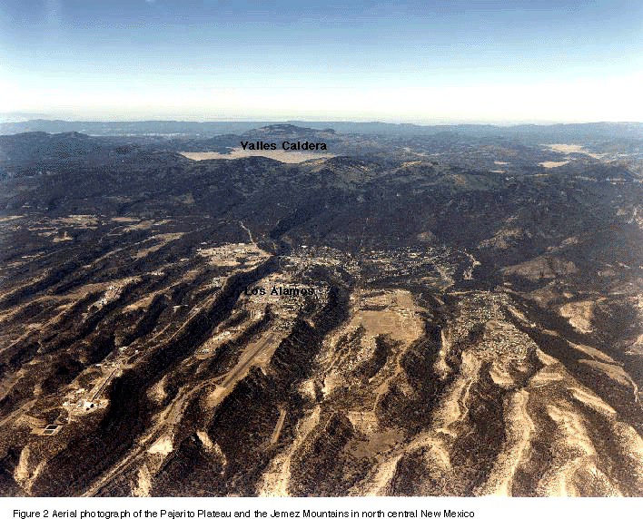
I have been coming to Durango, Colorado for at least 50 years.  Durango is the gateway to the towering peaks and deep valleys of the San Juan Mountains in southwestern Colorado.  The town is only a few hours from Los Alamos, and on many Fridays during my youth my father would pack my brothers and I up for a weekend trip to collect minerals in the La Plata Mountains (just west of Durango), or the San Juan Triangle (Silverton-Ouray-Telluride).  Durango was the perfect place either to bed down before exploring on the weekend or to buy supplies for longer stays in the mountains.  These trips to the mountains were probably the single most influential activity in my youth – they made me an Earthscientist, a mineral collector, a connoisseur of mining history and infected me with a love for high mountain peaks.  This October I came back to run in “The Durango Double” – at least the trail run (TR) portion.  The Durango Double is a celebration of running, and on Saturday there are trail runs of 25 and 50 km length, and on Sunday there are road races – a marathon and a half marathon.  I came to run the 25 km TR mostly to keep in shape, and to visit one of a favorite place. My version of the “Double” will be to ride my bike on Sunday up to Molas Pass on the road to Silverton.  A nice ride with an elevation gain of about 4600 feet.

ImageGeology Map of the Area traversed by the Durango Double.  The colors denote geologic “units” or rocks of a particular age and character.  The dark brown, olive, ochre colors are upper Cretaceous and mostly the Fruitland Formation.

Durango really is a gateway; it sits between the San Juan Basin to the south and the San Juan Mountains to the north.  The San Juan Basin is a tremendous energy warehouse.   Sedimentary rocks that were deposited in an ancient Cretaceous ocean that ebbed and waned along a continental highland are rich in coal, natural gas and petroleum.  The San Juan Basin is centered on Farmington, New Mexico, and forms a broad oval with Durango sitting at the Northern terminus. One geologic unit within the rocks of the San Juan Basin, the Fruitland Formation, has been a major source of coalbed methane – in fact in 2007-2010 the Fruitland rocks annually produced more than 1.3 trillion cubic feet of natural gas, making it the richest source in the United States.  It also just so happens that most the Durango 25 km TR is on the dark shales and sandstones of the Fruitland formation and adjacent Kirkland formation. Image

A view across the Animas River (looking to the north) at the real start of the Durango Double TR.  The hills are part of a major structure called the Hogback Monocline, and formally horizontal rocks dip sharply (35 degrees!) to the south towards the center of the San Juan Basin.  The dark bands in the hill are black shales from the Kirkland and Fruitland formations.

The San Juan Basin covers about 4,500 square miles in Northwestern New Mexico and a sliver of southwestern Colorado.  The Basin is like a giant thumbprint pressed into a layered cake.  The edges around the thumbprint are bent up and away from the center.  These upturned edges are called monoclines;  the Hogback Monocline runs along the northwestern margin of the San Juan Basin, and dominates the eastern and southern skyline of the town of Durango.  The Durango Double TR travels along the axis of the Hogback Monocline – the ridges are formed by erosion resistant sandstone and the valleys are soft shales.  The geologic cross section below shows a notional north-south slice through the San Juan Basin, and the Hogback Monocline is the upturned rocks on the right side of the figure. sanjuanb

Geologic cross section through the San Juan Basin.  The Hogback Monocline is shown on the right hand side of the figure

The Fruitland Formation is a series of shales, and sandstones, and coal seams that were deposited in a marsh delta – not unlike the Mississippi Delta of Louisiana today.  The ago of the rocks in this formation are about 75 million years, and they were deposited over a period of a couple million years.  The coal is an indicator of the large amount of plant materials that decayed within the ancient marsh.  There are a large number of dinosaur fossils, egg shells and tracks within the Fruitland included hadrosaurs and teeth from carnivores (thought to be from the genus of dromaeosurid theropod, which includes the velociraptor that lived 75-71 million before the present). When I run among the rocks during the Durango Double TR I can’t help but imagine what this place looked like 75 million years ago.  Probably not nearly as habitable, probably more dangerous, and definitely more damp!

A storm blew through northern New Mexico and southern Colorado on Thursday and Friday, and my journey up to Durango saw quite a bit of snow on the ground near Pagosa Springs.  I like “weather” when I run, but I was unsure what the TR would bring.  It was 30 degrees when we lined up for the start – too cold for shorts, but the cloudless sky promised by the end of the race it would be in the 50s, which is too warm for tights.  The sky was powder blue and it was a perfect day for a run!

beforetherace

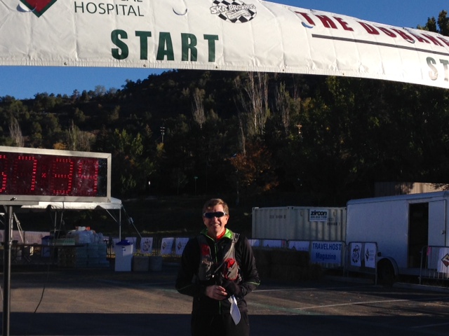
The starting/finishing line is on an alluvial terrance above the Animas River.  This photo also documents that I showed up a full hour before the race started, which is not a good idea when it is 30 degrees.

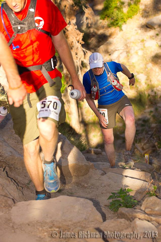
There were about 150 people in the 25 km TR, and mostly serious runners.  The race starts along the road for a mile and then begins a major climb up the Carbon Junction trail.  As is usually the case, I planned to go out at a steady pace and make sure I had plenty for the climbs and the end of the race.  Also as usual, my plans failed me;  the first mile was at an 8:55 min/mile pace, which is way too fast for me (I am a plodder not a runner).  There were people all around me running fast, and like a tide I got swept up.  However, once we were on the Carbon Junction trail all the pace stuff sorted out.  In the second mile the trail climbs 500 feet, and it is a grind.  The trail is on the Hogback now, but the material exposed is glacial outwash — a wonderful menagerie of granite boulders, schist cobbles, and even chunks of limestone.  The trail surface is wonderfully soft, and easy to run.

mile2

The vista to the north at about the end of the second mile.  The highest of the snow covered peaks in the distance is Engineer Mountain — the target of tomorrow’s bike ride.  Not a cloud in the sky.

After mile 2 the trail is within the Kirkland and Fruitland formations.  Yesterday’s snow has made the trail very muddy, and the clay content of the shales is high.  There were several times that the mud actually “sucked” off my shoes.  Still a nice trail, but  by the top of the pass I was carrying an extra 3 pounds of the Cretaceous!  At five miles the TR tops out on one of the Hogback ridge crests, and the total climb is a little over 1000 feet.  A very fast decent into a closed valley called Horse Gulch.  The valley is beautiful — and although most of the runners are heads down and really running, I am looking at all the remains of old coal mines.  They are everywhere – but you do have to know what you are looking for.  As noted, Durango is the bridge between the San Juan Basin and the San Juan Mountains.  It owes its very existence to both.  Durango became the smelting center for Silverton and the La Platas — trains ran down the Animas and from Hesperus bringing ore to Durango, and the abundant coal fueled smelters to process the gold and silver ores.

durangosmelter

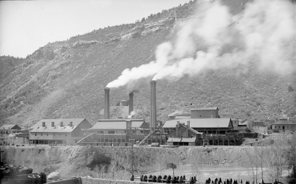
This is a picture of the American Smelting & Refining Company (ASARCO) Smelter in the early part of the 20th century. It was built on the southern side of the Animas River, and dominated the Durango skyline – it was incredibly toxic also!  By the time I visited as a child the smelter had been removed, but there were huge piles of black slag (rock that was processed and melted to extract the precious metals).  Today all that is gone, and unless you know Durango you see no sign of its glorious mining past.

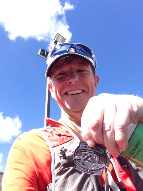
The TR does a loop through Horse Gulch, and then heads back over the ridge – so another 600 foot climb.  After reaching the ridge line I was pretty much running alone — not fast enough for the athletes, but too fast for the college kids that thought it would be cool to run a 25 km TR.  The mud on the way down had just as much suction as coming up, but it seemed easier because gravity was helping pull me along to the finish line.  I finished in 3 hr 9 minutes;  I had really hoped to break 3 hrs, but it just wasn’t to be.  At the finish line the organizers served a lunch of tacos (how can that ever be bad).  I enjoyed the run most because I knew its geology, and I knew of the history of Durango.  It was a visit to place in my life’s past.  I did not have time to find any Cretaceous fossils, but I did ponder the sucking mud and wondered if the swamps of 75 million years ago were as sticky.

finish

History Locked in Stone: Why Hessite is a Noble Mineral

Every block of stone has a statue inside it and it is the task of the sculptor to discover it — Michelangelo

Image

One of my favorite places to visit is the Naturhistorisches Museum Wien (Natural History Museum of Vienna).  As far as natural history museums go, it has to be the most important in the world.  It has display space of 8,500 sq meters (about 94,000 sq ft), and it is filled with more than 30 million objects.  The exhibits are decidedly old school: instead of modern interactive computer screens meant to entertain, there are taxidermy marvels documenting the discoveries of the great 18th and 19th century naturalists that explored the world as scientists. There are great fossil finds, meteorites, and stone-age works of art, and of course, there is a fantastic collection of minerals!

Image

The museum was built to house the collections of the Habsburg Empire.  The House of Habsburg ruled much of eastern Europe between the late 16th century and World War I. Emperor Franz Joseph I is credited with creating the museum in the mid-19th century, and the present building opened its doors in 1891.  The core of the mineral collection is from the great mining regions that the Habsburgs controlled—Bohemia, Hungary, Austria, and what would become Romania.  The oldest specimens were acquired by Archduke Ferdinand II, assembled in what is known as the “Ambrasian Collection”, and brought to Vienna in 1806.

To me, the minerals from the great Eastern European mining centers are masterpieces.  Not only are they fine aesthetic specimens, but they are also artifacts that capture human history.  Just as Michelangelo spoke of “releasing” the great artwork contained within a block of marble, the minerals that were collected out of the mines of Pribram, the Harz Mountains, Freiberg and Tyrol contain the stories of empires, miners, the birth of mineralogy, and the passion of collectors.  Life was hard in the mines, backbreaking, dangerous work with a single goal—to produce bullion.

In Europe the rise of interest in natural sciences meant that unique specimens were preserved starting in the late 18th century.  These specimens went to the collector cabinets of scientists and wealthy gentlemen.  The specimens were studied and catalogued; eventually they made their way to museums or other collectors who added their labels and love, until today we have lumps of silver or gold ore that tell a human story.  The tradition of collecting minerals from the mines was not passed to America until the latter part of the 19th century.  The mines on the Comstock Lode on the eastern slope of the Sierra Nevada were some of the biggest silver producers ever; but they were discovered in 1859 and exhausted in about 20 years, so the number of documented specimens from the Lode is remarkably few.  It is hard to imagine what mineral collections would look like today if the Comstock had been located in Bohemia.

Image

My favorite mineral in the museum is a spectacular cluster of hessite crystals, with associated quartz crystals.  The specimen vaguely looks like a hand with the two fingers extended.  The overall length is about 10 cm.  Hessite is a silver telluride (Ag2Te) and usually is a dull gray.  Hessite forms in medium or low temperature hydrothermal veins and is fairly widespread but almost never as crystals or even recognizable masses.  What makes the Vienna piece so amazing is that the crystals dwarf most others in the world.  The specimen is from Botes, Romania. There is a relatively small series of mines in the “Golden Quadrilateral” in Transylvania that for a few short decades produced a quantity of hessite that is unequalled in quality.  In fact, Botes hessite is so outstanding compared to other localities that it is often considered a “single locality” mineral.

Image

The northwestern quadrant of Romania is known as Transylvania, a high plateau surrounded by mountains.  Upon hearing the name “Transylvania” the average person has visions of vampires and Dracula; however, to a serious mineral collector the name evokes visions of spectacular gold specimens, rare gold tellurides, and absolutely amazing hessites like the one in the Vienna Museum of Natural History.  The “Golden Quadrilateral” is a region shown in the figure below that defines the largest gold resource in all of Europe.  More than half of the gold ever mined in Europe came from within the 500 sq km of the Quadrilateral, and it remains the continent’s largest gold reserve.  Along a north-northwest trend near the ancient town of Zlatna are a series of amazing deposits in the Apuseni Mountains.  These deposits are calc-alkaline volcanic centers that are the response to the collision of Italy to Europe.  The volcanoes were active between 15 and 2 million years ago.  The map below shows these centers in orange, one of these is marked with a “B” which denotes a modest mountain known as Botes Hill.

Image

Mining for gold in the Apuseni Mountains started at least 2,500 years ago.  Analysis of gold artifacts found throughout the ancient world, including Troy and Egypt, indicate an origin from the Apuseni deposits.  Before the Roman Empire, the region was known as Dacia; Emperor Trajan conquered the region in 106 AD.  The Romans sacked the Dacian Royal Treasury and hauled off more than half a million pounds of gold and twice as much silver.  Presumably, this wealth was originally mined from Apuseni.  The mining center during Roman times was Ampulum, which became the modern town of Zlatna.   The region bloomed again as a mining center in the 19th century when the area was under control of the Habsburgs.

The Golden Quadrilateral is rich in tellurium; in fact, the element was first described from samples of native tellurium from here in 1798.  Many gold and silver tellurides were first described from here, including krennerite, nagyagite, petzite, stutzite, muthmannite and museumite.  Hessite was actually first described in what is modern Kazakhstan (and named for a German chemist that described the mineral in 1829), but by far the best crystals are from Botes.  There is very little written on the history of Botes.  This is mainly due to the fact that it was a modest mine in terms of metal production, but in terms of hessite production it was truly remarkable!

Image

I have 5 hessites from Botes.  Most are like the specimen above—a cluster of crudely cubic grey crystals on matrix with quartz (and usually a little sphalerite). To many modern collectors this specimen has limited aesthetic appeal; however, every one of these specimens has a series of old catalogue numbers and labels written by the hand of long deceased collectors.  Botes only produced hessites for a relatively short period in the second half of the 19th century; all five specimens are “related”.  My favorite hessite (pictured below) is a cluster of elongated crystals (the largest blade is 1.4 cm) on a sliver of matrix.  The hessite crystals have blebs of gold on their surfaces.  The original mineralogical explanation for this assemblage was that petzite (petzite has a formula of Ag3AuTe2, simplistically, a gold atom substituting for every fourth silver atom in hessite) was intergrown in the hessite.  However, the most modern explanation is that the gold is actually intergrown directly in the hessite.  Either way, the gold blebs are a unique signature.

Image

Image

A visit to the Vienna Museum of Natural History is a reminder to me of why I collect minerals.  The minerals are magnificent recorders of past geologic events—ancient subduction zones and strata volcanoes, erosion and rearrangements of continents.  At some point the veins that carried the minerals were discovered by a prospector, and eventually mined.  Some nameless miner decided to collect a piece of unusual ore, which, in turn, made its way to a collector.  Through the years that mineral resided in display cabinets or wooden drawers in storage racks, and may have changed hands many times.  Scientists may have studied the sample and recorded the crystal structure or detailed the chemistry and postulated the theory of formation.  Today that specimen—a story in stone—is in my collection, but only as a temporary resting place until to passes to the next collector.

The Jemez Trail Run: A good run gone long

In every walk with Nature one receives far more than he seeks – John Muir

Image

Los Alamos is my home; I grew up in this town perched on flat mesas dissected with steep canyons cut in the volcanic tuff by a million years of rainstorms.  I loved the mountains of the Jemez and the thick forest of ponderosa pines, and I loved the town populated by special and odd people.  In the 1950s and 60s the town was “science USA”, and nearly everyone was an “outdoor buff”.  I moved when I graduated from high school in 1974, got my academic degrees, and went on to a 20 year career as a professor at the University of Arizona – but I always yearned for home. I was fortunate to have the opportunity to return a decade ago, and love my town more than ever.  It has changed – gotten lots older (people and homes), the lab is different, and the landscape has been ravaged by two horrendous fires (first in 2000, and then again in 2011 – both were the largest fires in New Mexico history at the time).  But the geology is the same – the high mountains are the rim of a super volcano that erupted and collapsed into a series of calderas during episodic activity 1.5 mya to about 600,000 years ago.  Los Alamos is built on the pale volcanic rocks that were erupted around the caldera;  these rhyolites were laid down like a snow fall building a large flat plain which we call the Pajarito Plateau today.  This Plateau has been eroded so there are a series of mesas and canyons giving the landscape a rugged feel.  It is through these canyons and mesas, and beyond to the rim of the caldera that the Jemez Trail Run is conducted every May.

I decided to participate in the 50 km version of the Trail run last December (2012). I have always loved to hike and bike but I was not a runner.  In 1998 I received an artificial hip on my left side, and in 2009 I received an artificial knee in my right leg.  Strong instructions from everyone – do not ever run!  But life caught up with me.  In 2011 both my parents, Los Alamos residents, died.  The 2011 Las Conchas fire roared across the Jemez mountains in late June and burned more than 150,000 acres of our beloved pine forest.  I gained weight and was not particularly happy.  So in 2012 I decided to reconnect, and running through the mountains was a big part of that.  By the time the Jemez Trail Run was open for registration I was on the path to adventure.  When May 25 rolled around I was ready for the 31 miles with nearly 7000 feet elevation gain! Until I read the weather report, and it was going to hot, very dry, and windy – I don’t like hot!

Image

Trail map – the course starts/ends at the bulls eye, and the red line is the 50 km course.


Running the Jemez Trail Run 

The Jemez Trail Run has three races – a 50 miler, and 50 km, and a half marathon.  All are in the Jemez, mostly single track, and all have at least one horrendous climb. All the races start on one of our mesas – in this case on North Mesa at an historic building called the Posse Shack.  The 50 milers start in the dark at 5 am;  the 50 km folks start at 6 am, but most are checked in and ready for action by 5:30.  I was quite excited and ready to go – I was geared up with water bottles, gels, energy bars, my trusty garmin watch, and most importantly, my lucky hat.

The race is put on by locals that devote a tremendous amount of time and effort.  The race support is absolutely first class, and the aid stations are certainly better than most school cafeterias!  Everyone  was supportive, and certainly everyone had advice for me.  “Don’t go out too fast”, “triple the amount of electolytes you think you need”, “walk every hill!”, “EAT”, and so on.  I appreciated the advice, but I had a plan – I had covered the course numerous times in the last 5 months and had figured the pace for every single mile I needed to make a time of 8 hr 30 minutes.  That is not a great time, but it was something I though I could do.  My back ground is theoretical science, so it is fair so say I had analyzed everything I could, but lacked practical experience…..

Image

Tom Stockton (the Race Director!) started the race – all the runners were ready, but sort of chaotic.  Tom wandered to the front and asked “Is everyone ready to go?” That was met with a nervous “sure” from the nearly 200 runners. So Tom said “Okay, go”.  That was it – suddenly everyone was running and I was picked up in the laminar flow, not really sure how to execute my plan.  Mile 1 drops down off North Mesa into Bayo Canyon.  It was fast – I was running a 9:30 minutes/mile pace which was not to plan.  The dust from the faster runners hung in the air like a fog.

Image

I felt comfortable, and tried to ease back into a 12:30 pace that I had planned.  The first aid station was a mile 5, and I felt great – ran right past the station, sucked down a mocha power gel, and started thinking about how easy this was actually going to be!

Image

At mile 7 the course is running the Perimeter Trail only a few hundred yards from my house.  I had a quick flash that maybe I should just go home, but I was feeling way too good.  The first difficult part of the course is a very steep and slippery descent into Pueblo Canyon, and steep ascent, and then a steady climb for a mile up a small mestia of rhyolite called Quemazon Mesa (appropriately named – translates as “big burn” and it did burn in 2000).  Finally this drops back down into Los Alamos Canyon at near our local ice skating rink.

Image

The elevation at the bottom of the canyon is 7200 feet and change.  Now the run, at mile 8 or so, really begins.  The next 7 miles is a climb of about 3200 feet. After climbing the 250 feet out of Los Alamos Canyon the trail heads toward Pajarito Mountain and our local ski hill.  The climb starts steady, but at mile 9 it runs into a cliff a couple of hundred feet high.  This is the scarp of the Pajarito Fault, and dominates the lower Los Alamos landscape.  I was definitely walking the Fault!  Finally, at the top of the scarp is the second aid station – 10.6 miles into the race.  The food there was a godsend, and I drank like a camel at the oasis in the desert.  I was still feeling pretty good, and thinking I was right on course with a time of about 2 hrs and 10 minutes for 10.6 miles.  I knew the next portion was a grind, but I was thinking perhaps I was actually a runner!

Image

A couple of miles beyond the aid station the trail breaks out into a flatish region known as “Geist Gap” (after one of the many great Los Alamos runners). This section was burned both in 2000 and again in 2011, and the land scape is barren.  There is still soot on the trail, and the sun beats down on you in full glory.  I began to wilt, and wondered if some how I had eaten something bad at the last aid station (no way was that true, but my energy was draining fast).

Image

Geist Gap intersects the Pajarito Ski Hill at about mile 13 at an elevation of 8,800 feet.  Here the trail becomes both spectacular and sinister.  The trail is wonderful single track that is not rocky, and soft with matted vegetation.  However, over only 2.5 miles the climb is 1,600 feet.  I had practiced this climb many times, and was sure that I was prepared – but I was wrong!  The climb took me over an hour, and when I peaked out on top of Pajarito Mountain I was exhausted.  The view from the top is spectacular, but I don’t really remember it at all.  The descent to the ski lodge and aid station 3 is steep, and should be swift.  It was just steep.  I stumbled into the 17 mile aid station at 5 hrs and very tired.  My wife was there waiting and giving me support, and the aid station was enormous – filled with all sorts of food and drinks.  I refilled my water bottles, ate what I could (my stomach wanted nothing to do with the food), and drank cold water.  Finally, my wife dosed me with ice water, which is probably the single best thing that has happened to me in a year.  My core began to cool, and I decided that I could make the last 14 miles easy.  I grabbed some food, and decided to walk a couple of miles to regain my composure.

Image

It is a lovely walk from the Ski Hill through a large meadow that is called Canada Bonita.  This is where we locals snow shoe in the winter – no sign of snow now though.  I began to feel much better and actually began to pass people even though I was walking.  About 3 miles from the Ski Hill is the fourth aid station – known as the pipeline station after the road that was built to bring a natural gas line into the Lab back in the 40s.  This aid station was manned by the Los Alamos High School cross country team, and I was feeling good enough to eat and chat about the end of the school year.  I knew it was almost all down hill from here, and only about 12 miles.  Anyone can go 12 miles I thought.  When I say “almost” all down hill, the almost is because there is one ugly climb, locally known as “kick-ass hill” that is about 300 ft high in less than a third of a mile.  Today though, kick-ass was no problem.  Climbed that devil and was flying down hill towards home!  Now, by flying, I mean I was holding a 13 minute per mile pace.  But I felt great.  This section of the course descends the Guaje Ridge trail.  It is a beautiful trail, but the ridge was ravaged by both fires.  After about mile 23 there is no vegetation except scrub.  Charred stumps of formerly mighty pine litter the mountain side.

Aid station 5 is at the intersection of Mitchell Trail and Guaje Ridge Trail.  The folks that run the ½ marathon run up Mitchell Trail, and then back again along Guaje ridge.  It is a heck of a challenging 13.1 miles, and I am shocked when I see the winners can do it in a little over an hour and a half plus change.  Most of the runners take more than 2 and a half hours.  I fill up at this aid station only 7 miles from the finish.  I am confident, but I can’t seem to cool off.  I drink lots of water, refill my bottles, and dose my head.  I take off at a good pace – down to 12 minutes a mile, certain that I will make a time of 8 hrs and 18 minutes (I have done this before so I know that answer!  I was wrong).  The sun is beating down on me, and I realize that the humidity is probably in the single digits.  I drink every 5 minutes.  Even though the course is down hill my pace begins to fad.  About 3 miles from the finish, and 1 mile to the last aid station, I stumble and as I catch myself both of my legs cramp in the upper thighs.  The pain is intense.  I stop and massage my thighs – everything is slowly relaxing, so I can begin a waddle down the trail.  Carefully, I ramble into aid station 6, and eat some of the best tasting watermelon I have ever had.  Only 2 miles to go – and I have run this part of the trail dozens of times.  I start in a walk, and slowly ease into a shuffle.  I am cooking now – cruising at a 15 minute per mile pace.  I am almost there!  The last 1/3 of a mile is a climb back up North Mesa along a trail carved in the soft rhyolite.  The trail is really a deep rut – in some places the rut is 3 feet deep and only 15 inches across.  In the middle of this climb my legs cramp – crap, I am stuck in the rut and can’t move!  This is terrible – what if I have to be rescued from the rut!  Mustering all the Zen I can imagine, I relax my legs and slowly finish the climb.  I cross the finish line a little under 8 hrs 36 minutes.  My wife this there, as are many of my friends that are actually runners or athletes.  All offer congratulations, but I just grunt and head for the ice water coolers.  9 cups of water later I am starting to realize that I did survive.

Image

I am joyful for the experience, and loved every minute of the run.  Los Alamos is blessed with people to make this even happen – the town is filled with trails for running, and the community takes care of all this.  Although it was not particularly easy, I am happy.  Now I have to get on my bike and ride the Tour de Los Alamos in two weeks (I wish I had ridden my bike in the last three years….but that is a new adventure).