Tales from the Tags: Mineral Labels and Specimen Value

I go down to Speaker’s Corner I’m thunderstruck They got free speech, tourists, police in trucks Two men say they’re Jesus one of them must be wrong – Dire Straits, 1982 song Industrial Disease

chacloacanthite

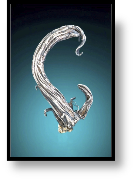
Chalcopyrite coating acanthite Joachimstal, Bohemia (now in the Czech Republic).  Originally in the A.F. Holden Collection, bequeathed to the Harvard Mineral Museum, traded out and sold to William Pinch, and eventually came to my collection from dealer Cal Graeber.

One of the questions I get asked most often when I visit a mineral show: “Is it real?”.  I mean this in a mineralogical sense, not a judgement of my personality.  The origin of the question is uncertainty about a mineral sample, and the particular inquiry is focused on whether the mineral is as advertised, or “fake”.  The nature of fakery in the mineral hobby can be subdivided into four broad categories:  (1) is the mineral actually identified correctly, (2)  has the mineral specimen been enhanced, repaired or constructed, (3) is the mineral actually natural, and (4) is the ancillary information with the specimen – locality information, previous ownership, etc. – correct?  To me, the last category is particularly vexing.  The ancillary information, usually provided in a label or series of labels associated with a specimen, documents the history and significance of the specimen. I collect minerals partially because of the their “science” (chemistry, geology, and crystal beauty), but also because they are artifacts of history.  Someone had to mine the specimen, decide it was worth keeping, pass it on to a collector or dealer that valued it, and finally making its way to my collection.  From underground mine to my collection the specimen develops a patina of human history.  I very much value this history —  the story in the label with the mineral is part of its “worth”. The specimen pictured above is an exemplar of a mineral as a historical artifact.  The specimen is a miniature sized matrix acanthite with an epitaxial coating of chalcopyrite. The locality is Joachimsthal, one of the most important historic silver mining regions in the world.  The specimen has a well documented pedigree:  it was in the A.F. Holden collection that was bequeathed to the Harvard Mineral Museum in 1913, and transformed Harvard’s collection from a typical university cabinet into one of the world’s greatest mineral holdings.

Chalco.acanthite

Labels for the chalcopyrite coating acanthite specimen pictured at the top of the article. The specimen was in the A.F. Holden collection, went to Harvard, traded to a dealer that sold it William Pinch. Eventually, Pinch sold the piece and it made its way to my collection in the 1990s.

In 1912 the Engineering and Mining Journal declared that the finest collection of minerals in the United States is “believed to be that in the American Musuem of Natural History in New York, the basis of which was the famous Bement collection. There are several important private collections. Among those, that of Col. W.A. Roebling, Trenton, N.J., is considered to be the best; anyway, the largest. Next in rank are probably the collections of A.F. Holden, Cleveland, Ohio and Fred Canfield, Dover, N.J.” Albert F. Holden graduated from Harvard in 1888 with a degree in Mining Engineering. After graduation, Holden entered the family mining business, and by 1906 he had built one of the largest mining and refining companies in the world. His holdings included what would become the Bingham Canyon copper mine in Utah, and dozens of mines spanning the mineral wealth of Alaska to Mexico.  In the 1912-13 Annual Report on Harvard University, the curator of the Mineral Museum, John Wolff, wrote “received this year a mineral collection which represents the greatest single gift of minerals made during its history of one hundred and twenty years…Mr. Holden had found time in the last eighteen years to accumulate one of the finest private collections in existence….As a result, the larger part of the six thousand specimens are of the highest quality, while many are unique.” In the detailed instructions to Harvard accompanying the collection, Holden wrote “There shall be no obligation on the Museum authorities to keep any of the specimens when they have lost their scientific interest”. Although the chalcopyrite coating acanthite in my collection is modest, its tie to a mining great, and subsequent membership in the Harvard Museum, and ultimately its pathway into one of the great modern collectors, Bill Pinch, is what makes it “more” than a pretty mineral.  Remove the labels, and the specimen is interesting, but it loses its significance.  The tale told of specimens from labels is their character — and it is also why labels can also be used to deceive or misrepresent.

Acanthite.Vaux

Acanthite mounted on a wood pedestal from Bryn Mawr.

The original mineral twitter:  Mineral Labels

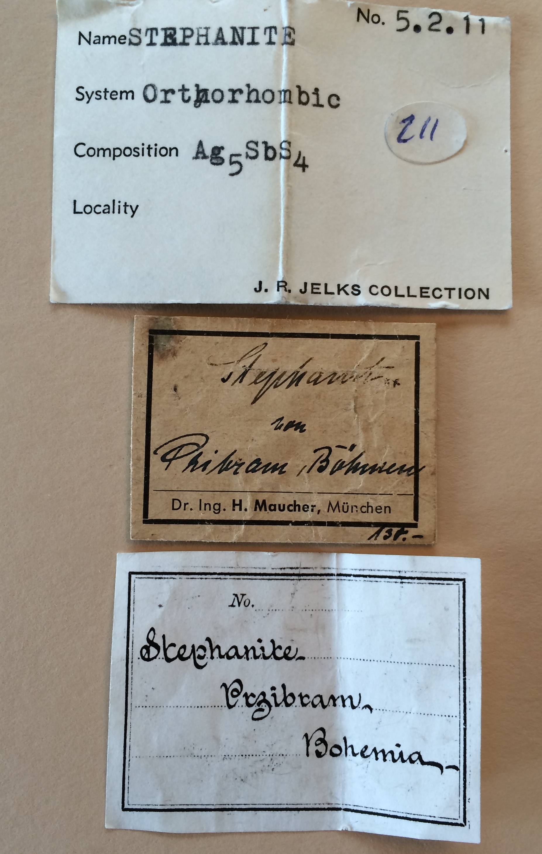
I am often surprised that many mineral collectors don’t spend much intellectual capital on the pedigree of the specimens that they pursue and collect.  That statement is, of course, a gross generalization because there are many collectors that intensely focus on the specimen history, but most collectors are first and foremost interested in the perfection of the specimen itself.  However, every specimen has a story to tell, and often that story is gleaned from a few lines written on an old mineral label.  Although labels may only contain the briefest inscriptions, these are often delightful clues to the thoughts and passions of the original collector. The picture above is a large thumbnail of acanthite from the Las Chispas Mine, Arizpe, Mexico.  For a very brief period, the first decade of the 20th century, the Las Chispas mine near Arizpe in Sonora produced some of Mexico’s largest and best specimens of polybasite crystals, large clusters of “poker chip” stephanite crystals, fine acanthite crystal clusters and a few very fine pyrargyrite specimens. Many of the specimens were saved through the enlightened efforts of mine manager Edward L. Dufourcq (1870-1919), and now populate museums and privates collections worldwide.  The pictured specimen is fairly unremarkable, even if distinctive of Las Chispas acanthites.  However, the label (and the wood stand that holds that displays the specimen) are what make this a historical artifact.  I purchased this specimen from a dealer in 1986 – but what I saw when it was displayed in his stock was the label — it is a very distinctive “Vaux” tag! George Vaux (1863-1927) was an attorney and member of one of the most important Pennsylvanian families – in fact, he was the 9th George Vaux (and passed the name on to his son too!). George Vaux was the nephew of William S. Vaux, who one of the earliest American mineral collectors. George followed his uncle’s lead and passionately collected minerals. When he died in 1927 he had amassed an amazing collection, particularly rich in South American and Mexican specimens (Vaux’s Chanarcillo proustites are still considered some of the finest examples of what I believe is the most beautiful mineral). Vaux lived in Bryn Mawr, located west of Philadelphia, and upon his death his family kept the collection intact and on display in their home. Bryn Mawr is home to the small college of the same name, founded by the Religious Society of Friends (Quakers) in 1885. In 1958 the family decided to donate his collection of more than 8,000 specimens to the college – and suddenly a small women’s liberal arts college had a major mineral holding! The transfer of the collection included Vaux’s labels – there are several types, but several thousand were the simple lined cards, with handwritten descriptions (like the one pictured above). In the early 1980s many of the Vaux specimens were traded out of the Bryn Mawr collection, including my acanthite.  The wood stand and black wax mount were Vaux’s work.  On the base of the stand Vaux wrote “Cahn, 11/20” which indicated that he had bought the specimen from Lazard Cahn, a Colorado Spring mineral dealer.  Eventually, it was acquired by Al McGinnis (a San Mateo dealer) for his private collection, which was dispersed upon his death. A few years after I acquired the Arizpe acanthite, I found another Vaux labeled acanthite specimen in the stock of mineral dealer Gene Schlepp.  In fact, the Vaux label was was tagged with the number 703, only a few digits different than the Arizpe piece!

agularite.calcite

Aguilarite, Guanajuato, Mexico.

The Vaux label stated that the specimen was Argentite (acanthite) from Guanajuato, but I suspected the specimen was actually Aguilarite (Ag4SeS), a far rarer mineral.  The skeletal dodecahedrons are distinctive of the species, and the specimen looked very much like the very best aguilarites I had seen in other collections.  I purchased the piece, and hurried off to the lab to do an x-ray.  My hopes were confirmed – a outstanding aguilarite with history to boot!

agularite.label

Vaux label

The front of the Vaux labels only tells part of the story.  Turn over a Vaux label and there is a few scribbles that connect Vaux to his mineral suppliers.  Below is a picture of the Arizpe and Guanajuato labels.  In Vaux’s hand writing you can see where and when he acquired the specimens.  The Aguilarite was obtained from Wards in 1895 — which is very consistent with the very best samples were mined.  Around 1890, Ponciano Aguilar, superintendent of the San Carlos mine at Guanajato collected an “unknown” that he thought might be Naumannite, and sent it to S.L Penfield for identification — and Penfield discovered it was a new mineral and named it in honor of Aguilar.

vaux.labels

Back of the Vaux labels; where the specimen was purchased, when it was purchased, and a three letter code. The code is likely the purchase price.

A mystery on the Vaux labels are the three letters scribbled after the date of purchase.  I have looked at about a dozen Vaux labels and they always have these initials, all different.  Wendell Wilson, editor of the Mineralogical Record, suggested that this might actually be an encrypted purchase price.  Several collectors from the first half of the 20th century used ciphers to record value.  Martin Ehrmann used “tourmaline” as his  cipher — 10, non-repeating letters, each corresponding to a numeral, 1-9 and 0 (e.g.  tne would translate to 190).  Carl Bosch, whose fabulous collection ended up in the Smithsonian Institution, used a similar code, with amblygonit thought to be the cipher used to record value in German Marks.  I don’t have access to nearly enough of the Vaux labels to “break the code”, but it is likely that the three letters are some important secret about the specimens. Not all minerals come with a rich history, and when there is a documented pedigree it is still hard to convert that history to a monetary value.  The Vaux labeled specimens in my collection are cherished by me, but in the future (hopefully distant future) when they are sold to other collectors the value will be mostly determined by comparison of the specimens with “their peers”.  The aguilarite will still be one of the best in the world, with or without the label.  But the real value will be the story behind the minerals – it may not be monetary value, but it will be fingerprints of humanity on stones recovered from the Earth.

wallace.bideauxite

Bideauxite, Tiger, Arizona

When Labels Go Bad

One of specimens I treasure the most in my collection is a Bideauxite, a very rare lead-silver chloride (Pb2AgCl3(F, OH)2) from Mammoth-St. Anthony Mine, Tiger, Arizona.  The photograph above is a closeup of my specimen, and displays two hexoctahedral crystals of Bideauxite associated with boleite on a quartz matrix — the crystals are tiny, only a few mm across.  The unusual chemistry of Bideauxite requires a very restrictive set of conditions for formation, and in fact, the mineral is only documented to come from two localities:  Tiger and a small prospect in  Tarapaca, Iquique Province, in northern Chile.  The species is named after the late Richard Bideaux, a good friend and a fountain of knowledge for all things mineralogy (he is co-author of the Handbook of Mineralogy), especially Arizona mineralogy (co-author of Mineralogy of Arizona).  Richard “discovered” the mineral when working on his thesis at Harvard;  he was going through material in the Harvard Mineral Museum from Tiger and found a tiny gray-pink fragments of a mineral he thought was chlorargyrite on boleite.  Richard sent the material to Sid Williams who determined that it was a new mineral, and named it Bideauxite. In 2005, Dave Bunk bought part of the mineral collection that contained many specimens from Erberto Tealdi (the late editor of Rivista Mineralogica Italiana) collection. Tealdi collected a large suite of minerals from Colorado — and in the  material Dave acquired was the most amazingly labeled sample:  Bideauxite, Sherman Tunnel, Leadville, Colorado.  Acquired, Rich Kosnar.  Looking at the sample I immediately knew that it likely Bideauxite, but what a bizarre reference to the Sherman Tunnel!  Never has there been a more ridiculous assertion for a locality — wrong geology, wrong mineralogy, and about as believable as the theory that Roman Christians established a colony on the outskirts of Tucson, Arizona around 700 AD (this theory is based on an archeology hoax, but will live forever on the internet – I love archeological hoaxes!). It is clear that the original label listing the Leadville locality was used to deceive, but really it was a rather flaccid attempt. I eventually obtained the Bideauxite from Dave Bunk, and have labeled it as from “Tiger.” This is an example of a very troubling phenomena in which the Label is Bad.  In the case of the Bideauxite, the bad label has little consequence because  it was so preposterous.  However, for the very reason that labels add to the value of specimens — both in terms of history and monetary value — the issue of bad labels is one of the worst diseases in the mineral collecting hobby.

gold_the_dragon

The Colorado Dragon

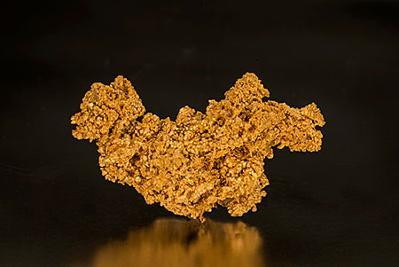
Recently, Pala Minerals published an article about the sale of arguably the most important Colorado mineral specimen — a gold sample from the early days of the Colorado’s rich mining history — in their internet newsletter (http://www.palaminerals.com/news_2014_v2.php). The specimen is fabulous – more than 5 ounces of crystallized gold that demands attention.  The specimen is reputed to be from the Gregory Lode, Gregory Gulch, Gilpin County, Colorado – the label is shown below.  The significance of the label is “Gregory” — as in John H. Gregory.  Gregory, a prospector from Georgia, is credited with discovering the first major Colorado gold deposit located near what would become Central City, in May, 1859.  Gregory sold his claims, and pretty much disappeared  (although there are many Gregory legends, mostly they are unsubstantiated canard).  The label changes the “Colorado Dragon” from a great mineral specimen and transforms it to a hugely signifiant historical artifact.  Further, the mineral label states that the gold actually belonged to John Gregory, and that he had personally donated the treasure.  There is absolutely no other evidence that Gregory collected or owned this outstanding gold, nor that he donated specimens, but the label titillates!

Kosnar.label1

Label included with the Colorado Dragon.  Note that it states Gregory donated this gold, even though he disappeared in the early 1860s.

The “original label” for the Colorado Dragon is stated to be from the State Historical Society. The State Historical Society received minerals originally acquired by the Colorado Bureau of Mines over a period of about 80 years, in 1956.  This mineral collection was filled with history – it had specimens from senators, miners, and millionaires.  The label above serves as exculpatory evidence for those that would cast doubt on the provenance of the gold.  The faded piece of paper with a few typed phrases links the nugget with the birth of the Centennial State.

Kosnar.label2

A label accompanying the Colorado Dragon, from the Colorado School of Mines

Eventually, the Historical Society gave the mineral specimens to the Colorado School of Mines, and it was placed into the Mineral Museum holdings.  The photo of the label above is stated to be the School of Mines tag associated with the specimen.  In 1990s the Colorado Dragon was obtained by Colorado Dealer Richard Kosnar (the same Kosnar associated with my bideauxite) from the School of Mines.  This year the specimen was obtained by George Hickox a noted Colorado gold collector. This would be a remarkable tale, but just as the labels add immeasurable value to the gold, they also cast a dark cloud over the authenticity of the specimen.  The problem is that there are at least two more specimens labeled “number 5600” – so three competitors to the throne!  Two of the specimens are labels EXACTLY the same (reference to donation by Gregory, which is certifiably false) including the  Colorado Dragon!  Just as the tag line at the top of the blog from the Dire Straits’ song says that when two people claim to be Jesus, one must be wrong! In the case of the Gregory Gulch gold there are three competitors for the label designated 5600.

CSM 5600 with CSHS label

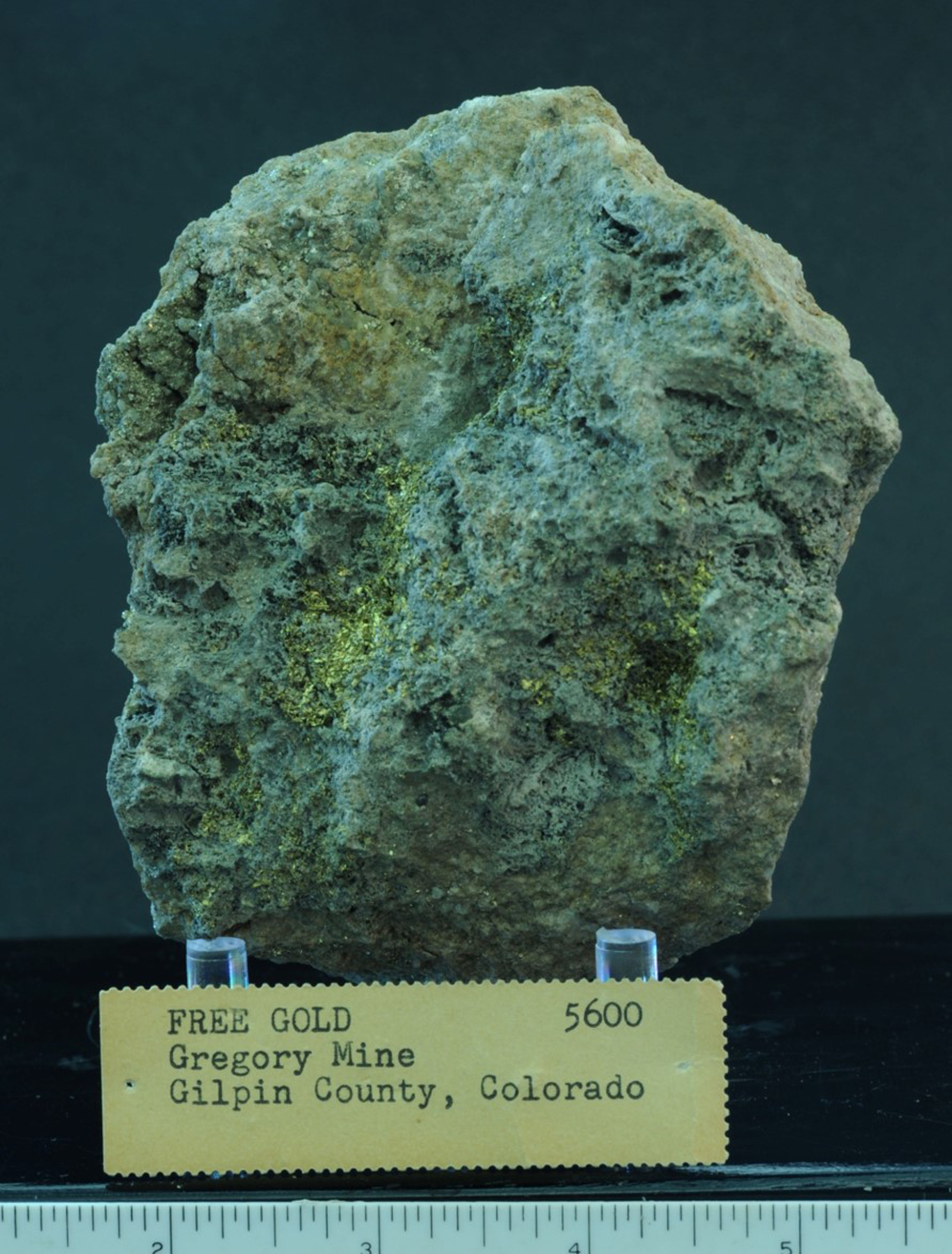
Number 5600 in the Colorado School of Mines display.  Note no mention of a donation by Gregory.

The photograph above shows a gold specimen on display at the Colorado School of Mines, and it carries the number 5600.  This specimen has all the documentation to suggest that it is the original 5600, although no where is there any indication that it was donated by the original prospector. This does not mean the specimen on display is authentic. There are many reasons that the Colorado School of Mines piece could be a misrepresentation — including an attempt by someone at the School of Mines to cover up trading away the original Colorado Dragon.  But that said, two specimens with the same number, and at least one of those with very questionable historical references? At the very least, one is left with a tremendous sense of uncertainty, and anger that such an important historical artifact is now tarnished. Ed Raines is the Collections Manager at the Colorado School of Mines Geology Museum, and one of the most knowledgeable professionals I know of in terms of Colorado minerals.  Ed is also a bulldog – he pursues information with tremendous tenacity, and is a stickler for facts. He understands the importance of Gregory gold, and has scoured the records to shed light on the mystery.  Along the way he found a third specimen labeled 5600, now in another private Colorado collection!  Two is bad, three is ridiculous.

Lau collection Old 5600

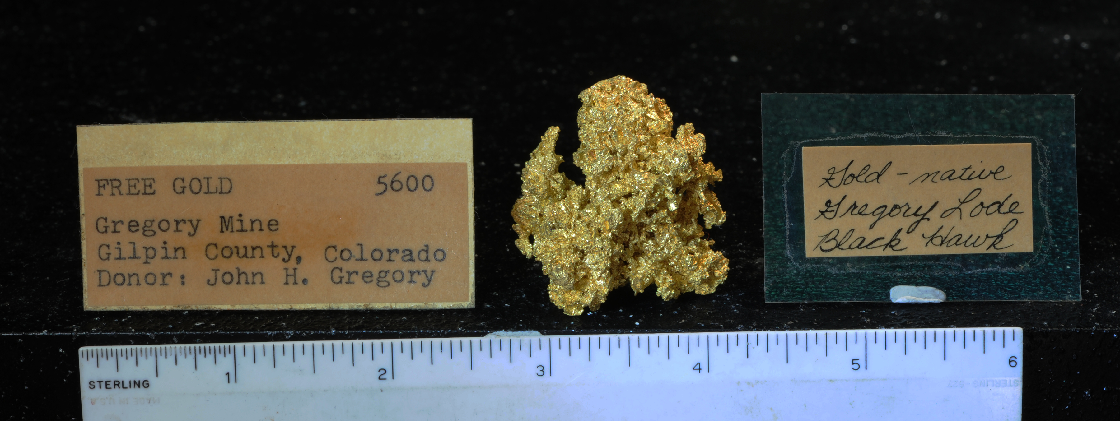
Another 5600! In a private collection

The picture above shows this third specimen, and its label — identical to the one with the Colorado Dragon.  This third specimen was also acquired from Richard Kosnar.  Without labels, all three golds would be interesting specimens;  with the labels they become locked in the evidence room of speculation and innuendo.  Just as labels add to the “value” of many specimens, these simple tags can cast doubt, and ultimately, disgust.  The principals in the original transactions may know the real facts, but today there is only conflicting labels and at best, duplicate specimens.  In my professional life I am asked to make judgments based on incomplete and conflicting data;  I can not conclude anything from this mess other that someone(s) behaved inappropriately.

Why do Collectors Believe?

There are untold numbers of minerals that are inappropriately mated with labels. There are obvious examples where this matching is done with malfeasance – simply mineral fraud. Every collector is also familiar with unintentional mislabeling. This usually occurs when old collections have fallen to a state of disrepair, and labels become disassociated with the physical specimens. There are many tales of collecting apocalypse where carefully nurtured and curated collections that are passed along to uninterested progeny only to end up in a garage sale (I did acquire an outstanding jalpaite thumbnail in estate sale once for the princely sum of 3 dollars!). There are also many labels that are applied to specimens based on “guesses” – some are educated guesses and sometimes they are little more than wishes and hopes (my bideauxite pictured above is now labeled Tiger, but that really is just an educated guess). Unfortunately, once a label is attached to a specimen, however indelicately, it develops some credibility. This credibility resides mostly in the hearts of collectors – it is easy to blame unscrupulous dealers, but in the end it is the collector that decides the value of a specimen. The vast majority of mineral labels are above reproach; if there is something incorrect it is usually based on good intentions (e.g., when I label bideauxite as being from Tiger — no good intention is had by labeling it from Leadville!). However, there are some startling examples where mineral pedigrees that are incredulous, yet are accepted and promoted by knowledgeable collectors. This speaks to the psychology of collectors, especially the most passionate members of the hobby. Their pursuit of minerals can cloud their judgment to point of accepting the flimsiest evidence if it means they acquire something unique.

barlow.jalpaite

Barlow Chalcocite: originally sold as Jalpaite

I experienced an example of this power of wishful thinking in the early 1990s when I was asked to write a chapter documenting the silver specimens in John Barlow’s collection. John had acquired an incredible jalpaite, purportedly from the Caribou Mine, located about 20 miles west of the modern city Boulder, from Richard Kosnar. John’s later recollection of the acquisition was that he was skeptical of identification, but when I first saw the specimen in his home in 1993 he presented it as the world’s finest jalpaite – it is pictured above. Peering at the fine miniature, I reacted with typical skepticism and sarcasm – I laughed. I had seen the specimen in the pictured in the Mineralogical Record years before (1976 to be exact), but in person the specimen was stunning….just not jalpaite.  Laughing was probably not the best way to start a serious mineral discussion; nevertheless, John eventually had the specimen “tested” at the Smithsonian, and it was confirmed to be a chalcocite. It was a very fine chalcocite, but clearly was not from the Caribou Mine. John eventually came to terms with Kosnar, and decided that it was a chalcocite from Levant Mine in Cornwall, and had come to Colorado as a collectable by William Turnby, a partner in the Caribou mine back in the 19th century.  Turnby had spent time in Cornwall, thus, this became “a plausible explanation”. This is how the specimen was labeled in John’s collection when he died. Is the Barlow label believable? Not to me.

The most disquieting aspect of this story is that John Barlow was a very knowledgeable collector – why would he accept this fanciful explanation? John was not duped into his belief by an unscrupulous dealer, but truly believed he had an amazing treasure. This tale is hardly unique – many collectors have labels that they want to believe against a preponderance of evidence.

When Specimens are Historical Artifacts, not Works of Art

Mineral collecting has as many different facets as there are collectors. For many, minerals are works of art; for others, they are expressions of science. For some collectors, including me, minerals collections are ultimately an expression of humanity. Labels tell that human story. When labels go awry – intentionally or accidently, the story of a collection is diminished. Sometimes this is inconsequential, but other times, the mislabeling is historical theft.

Tsoodzil: An ultra run on turquoise mountain

How glorious a greeting the sun gives the mountains! John Muir, the great Scottish-American naturalist.

coverphoto

The Summit of Mt Taylor on race day. The view is to the east down the amphitheater.

80 miles west of Albuquerque a lone mountain peak rises above the horizon; it seems distant but significant, an alpine oasis in the high desert of the Colorado Plateau. The peak is Mt. Taylor, an extinct stratavolcano that towers some 5000 feet above the uranium mining boom town of Grants.  The high point of Mt. Taylor is 11,305′, located along the lip of an eroded caldera, and offers unobstructed views for at least 90 miles in all directions of the compass.  The mountain is one of four sacred peaks that surround the Dinetah, the traditional homeland of the Navajo.  The name Mt. Taylor was assigned in 1849 to honor President Zachary Taylor, but the Navajo call the mountain Tsoodzil, and more informally, the turquoise mountain – a name that it deserves as it appears to be a deep blue  gem on the horizon.

Mt Taylor is home to one of the three crown jewels of northern New Mexico trail running (the others being the Jemez Mountain Trail Runs and the La Luz Trail Run).  It is a relatively new event (the inaugural race was in 2012, although early versions of the run existed), but its fame, or at least admiration, has grown rapidly. The start and finish of the Mt Taylor 50k is a couple of miles west of the caldera rim and is at 9400′ elevation.  The course has some steep climbs (and equally steep descents) – about 7000′ elevation gain – much on single track, and through unspoiled mountain top wilderness.  I have wanted to do this race for some time, and signed up for the run within minutes of when the registration was opened in early February of 2014.  The run is limited to 175 people, and indeed, the roster fills early creating a waiting list.

Although I grew up about 100 miles north of Mt. Taylor, I had only visited the peak once; that was back in the summer of 1975 when I was an undergraduate student working summers at Los Alamos National Lab.  We installed a temporary seismic station near La Mosca lookout – which is on the course of the 50k! – to record seismic waveforms from a number of underground nuclear tests conducted in Nevada.  The nuclear weapons tests were part of Project Anvil, a series of 21 tests.  In 1974 the US and Soviet Union agreed to the terms of a bilateral treaty that would limit the size of nuclear weapons tests to 150 kt or less;  this treaty is known as the Threshold Test Ban Treaty (TTBT).  Although the terms of the TTBT were negotiated in 1974, both nations wanted to conduct a series of tests before it would come into force — this resulted in a period of frenzied activity for nuclear testing.  The treaty was submitted to the US Senate (but not acted on) in July 1976, and 150 kt became the punch line in numerous conflicts with the Soviets in the subsequent 15 years.  Little did I know at the time, but the concept of monitoring nuclear tests, and more importantly, determining the nuclear yield from geophysical data would dominate my career.  However, the installation of the seismic station on Mt. Taylor nearly 40 years ago was mostly a just a chance to visit at really interesting mountain top. I was far more familiar with the flanks of the Mt. Taylor were my father and I had collected numerous radioactive mineral species in the early 1970s. The Mt. Taylor 50k provided a long overdue opportunity to visit a wonderful New Mexico mountain.

bannerimage2

From the north looking to Mt. Taylor on the horizon above Mesa Chivato, and a volcanic plug called Cabezon in the right center (the picture is high resolution, so click on it).  The picture was taken while touring the geology of the Naciemento Uplift along the western margin of the Jemez Mountains.

Mt Taylor – A beautiful stratavolcano and tombstone

Mt. Taylor is a magnificent landmark – it really is an isolated volcanic peak on the edge of the Colorado Plateau, a huge region (more than 130,000 square miles) of relatively flat mesas and valleys with an average elevation of about 7000′.  The Plateau is a geologic mystery; it represents a region of relative geologic stability that has existed for  nearly a half a billion years.  All around the plateau there are geologic provinces that suffered tremendous episodes of geologic deformation – the Rocky Mountains, the Basin and Range in Arizona and Nevada, and the Rio Grande rift in New Mexico.  Why did the Colorado Plateau escape these tectonic spasms?

backgroundmap

Location map from Kelley 2014; The Mt. Taylor volcanic field is part of a series of volcanic provinces that ring the southern half of the Colorado Plateau. Mt. Taylor sits atop Mesa Chivato, which is a group of basaltic volcanic vents that were most active as Mt. Taylor became extinct.

Mt. Taylor seems unique, but is actually part of a much larger geologic phenomena – a ring of volcanoes that surrounds the southern boundary of the Colorado Plateau.  The most famous of these mountains in this “ring of fire” is the San Francisco Peaks north of Flagstaff. The Plateau is defined by a thick sequence of sedimentary rocks – some of these rocks were deposited in marine environments, others in wide river valley flood plains, and still others represent long periods of time when the surface was covered with wind blown dunes. Taken together, this block of real estate was near sea level for nearly an eighth of the entire age of the Earth. Around 25 million years ago the Plateau began to rise uniformly to its present elevation of 7000’ feet. The cause of this rise is a subject of much speculation and research, but most geoscientists accept that the uplift was due to a hot mantle. This idea holds the key to why the edge of the plateau has so much volcanism, similar to that that that produced Mt. Taylor. The juxtaposition of the thick, and obviously stable, lithosphere of the plateau and the much thinner lithosphere of the Basin and Range created what is know as Edge Driven Convection (EDC). This EDC brought hot mantle materials up toward the surface along the edges of the plateau and it melted rocks both in the upper mantle and lower crust which then erupted in a series of volcanoes.  The same reason Los Alamos has the marvelous Jemez Mountains is the reason Grants celebrates the glorious vista of Mt. Taylor.

crosssectionfromnorth

A notional cross-section through Mt. Taylor – the conical shape of the stratavolcano is a layered stack of andesites and ashes from eruptions. At some point Mt. Taylor probably reached 14 or 15,000 feet elevation; however, the volcano eventually blew its top and created the geomorphology that is seen today.

Mt Taylor first erupted about 3.5 million years ago, and was active for 2 million years.  The volcano had many eruptions that were mainly ash; these eruptions built an edifice that probably reached a maximum elevation of between 14 and 15,000 feet (which would have made the Mt. Taylor 50k much more difficult!).  Today there is a pronounced depression at the top — it is called the amphitheater — that is the eroded remains of a caldera.  The amphitheater is open towards the southeast and is drained by Water Canyon.  The shape of the amphitheater looks eerily like Mt. St. Helens 30 years after that volcano blew its top. As the volcanism of Mt. Taylor was winding down, a whole series of small vents developed to the northwest.  These vents extruded basalt rather than ash, and built a broad and flat table land known as Mesa Chivato.

mttaylor

Aerial view of Mt Taylor and Mesa Chivato. The high crest of Mt Taylor is visible in the new snowfall (the snow line is about 7000′ in this photo). The right of the crest is the amphitheater which drains to the southeast. The broad basaltic table land that is Mesa Chivato is to the upper right of Mt. Taylor (photo from Kirt Kempter) .

As spectacular as Mt. Taylor is, the rocks of the Colorado Plateau that sit beneath the volcano are more unique. There is a 2 km thick sequence of sedimentary rocks hidden below Mt. Taylor and Mesa Chivato, and these rocks contain one of the largest known reserves of uranium ore in the world. This uranium fueled the American nuclear power and nuclear weapons enterprises for half a century; it also brought tremendous devastation to the miners, in particular the Navajo miners, that extracted the ore from underground workings.

The long history of stability of the Colorado Plateau played an important role in making it a “trap” for uranium.  As great mountains of granite and ancient volcanoes rose and were eroded over the last half a billion years the rocks from these massifs were ground to cobbles and grains.  In turn, these grains slowly released their constitute minerals which reacted with the environment;  a tiny fraction of these minerals contained uranium, which was eventually mobilized by the ground waters and flowed through the rocks of the Plateau.  Occasionally these ground waters would encounter conditions that caused the uranium to precipitate out of solution and be deposited as new minerals.  When these conditions lasted millions of years the precipitates would become extensive enough to become uranium ore.  After WWII the US government started a prospecting frenzy for uranium, and the sediments of the Colorado Plateau became site of a new “gold rush”.

uraniummines

Location map for uranium mines that have produced ore to be milled. 98% of the ore came from mines in New Mexico, Arizona, Colorado and Utah – all on the Colorado Plateau.

Uranium was first discovered in New Mexico part of the Colorado Plateau in 1950.  A Navajo shepherd, Paddy Martinez, had heard about the uranium rush, and seen some yellow colored ore.  Martinez recalled seeing rocks with similar yellows stains at Haystack Butte, just west of Grants (strictly speaking, Martinez “rediscovered” the uranium deposits that others had noted in passing in the early 1920s), and started a mad era of exploration and mine development in the Grants Mineral Belt, which encircles Mt. Taylor. Legend has it that Martinez brought several pieces of yellow ore to stake his claim, and that the yellow ore was carnotite. I personally doubt this is true because carnotite is extremely rare in the grants Mineral Belt (I have never seen a single specimen). Nevertheless, the population of Grants went from a few thousand to 45,000 in a decade.  Two major mines were developed; Ambrosia Lake, north and west of Grants (you can see the mine workings as you drive up to the start of the Mt Taylor 50k), and the Jackpile Mine, a few miles east of Grants.  The Jackpile mine was remarkable; it was discovered in 1951, and between 1956 and 1960 it was the largest producer of uranium in the world – during the same time it produced more uranium than all other mines in the US combined!

jackpilemine

Jackpile uranium mine in full production in the 1970s.  Mt Taylor is visible on the horizon of the picture.

The ore of the Jackpile mine is dispersed uranium — mostly in the form of the minerals uraninite (UO2) and coffinite (U(SiO4)1-x(OH)4x) — in a sandstone that was created by a systems of braided streams that flowed from somewhere west and south of present day Grants in Jurassic time (145 to 200 million years before the present).  The host sandstone at the Jackpile defines a sausage shaped body that is about 50 km long and 25 km wide, and the average grade of ore is less than one percent.  However, it is clear that one of the factors that contributed to the deposition of uranium out of the ground waters was the presence of carbonaceous materials — dead plants.  Throughout the Jackpile sandstone there are large petrified logs – trees that must have been swept away in floods and then stranded as log jams – and these petrified logs are where uranium concentrations can rise to 20 percent or more.  In 1972 my father got a call to visit the Jackpile because they had discovered a cluster of logs that appeared to be completely replaced by uraninite.  I accompanied my father, and we collected about 20 pieces of petrified wood.  From our geiger counters it was clear that the material was radioactively “hot”, but the uniform dark color made identifying the minerals by sight impossible.  One of these logs became the source materials for my education in power diffraction. Back in Los Alamos we prepared about 15 different powder samples and my father performed the x-ray diffraction at work; he then brought home the films and it was my job to identify the diffraction peaks.  The material ended up being almost all coffinite.  I have long since gotten rid of all the material (safely and securely), but I learned how to identify minerals with x-rays on uranium grunge….sort of poetic justice I suppose.

u238chain

The decay chain of uranium 238 to radon and progeny. Although U238 is barely radioactive, its daughter radon 222 and subsequent decay to polonium 210 are cause of many miner’s lung cancer.

The Jackpile mine was an open pit mine, but many of the other mines had underground tunnels.  In general, the ventilation in these underground facilities was poor, and the presence of the uranium means that there was radon, which is a radioactive decay product. U238 is marginally radioactive (it has a half life roughly equal to the age of the Earth!), but when it does decay it will eventually produce radon gas as a daughter.  This gas is quite radioactive and decays by emitting an alpha particle.  The progeny of radon, in particular polonium, also emits an alpha particle.  Inhalation of radon allows the alpha particle emissions to interact with the very sensitive tissues of the lungs;  this irritation of the lung tissue dramatically increases the chances of developing lung cancer.  The cancer rates among Navajo uranium miners is extraordinary, and a very sad legacy of the mad rush to find the heavy metal.  A mineralogical sidebar to this tale is that in the year 1530, Paracelsus described a wasting disease that afflicted miners in Joachimsthal which he called male metallorum – we now know that is lung cancer from the exposure to radon.

The Navajo also associate Mt. Taylor with the home of the chief of the monsters – and by monsters, the Navajo means those things that get in the way of a successful like.  The monster the Navajo deal with now is leetso, the yellow dirt.  It is strange to write about running an ultra race and spend so many words on things nuclear.  But to me, there is always a celebration of the place of the race, and for Mt. Taylor there is a fabric that is very much woven by things nuclear;  a high peak overlooking a legacy, a cenotaph.

startofrace

Start of the race at 6:30 am. Cool and dark.

The race

I signed up for the Mt. Taylor 50k in February, and had every intention that it would be the my crowning achievement for ultra runs this year.  However, my approach to the race was quixotic at best.  I have run 4 ultras, many shorter trail run races, climbed Rainier, and done several cycling events this year, and by the end of September, my dedication to training for a long tail run had wained.  As September 27 approached I oscillated between unrealistic optimism and trepidation.  My base fitness was good – I run 30 to 35 miles per week and cycle 60 to 65.  However, I had not put in the long miles on individual runs that I needed for a tough ultra.  Further, much of the summer I had chosen to train for climbing Rainier (carrying a back pack, hiking 14ers in Colorado). In fact, I was still experiencing the effects of Rainier — I still had some blisters on my feet, and I had only partially recovered from an infection I got from stabbing myself in the leg with a crampon.  Finally, I had been called unexpectedly to DC the week before the 50k run for a very tough set of meetings and only flew back to Albuquerque late in the afternoon before the race.  But, then again, what could go wrong in 50 kilometers?

coloroffall

The race ascends the ridge below MLookout as the sun is rising. The color of fall is glorious. View to the west.

The race starts at 6:30 am – in the dark at Rock Tank Shelter.  The runners head due east and climb about 1500′ over 3.5 miles to the ridge just below the Mosca Lookout.  The goal is to reach the ridge as the sun rises above the horizon and welcomes Mt. Taylor to a new day.  I am quite certain that many of the runners made the ridge as the sun rose — I settled for a little more leisurely ascent, but nevertheless basked in glow of autumn colors and fantastic views.

thecourse

My gps track through the Mt. Taylor 50k.

The course for the Mt. Taylor race has three major climbs;  the Mosca Lookout ridge, the top of Mt. Taylor, and then a tough final climb up out of Water Canyon in the Amphitheater. After the first big climb the trail is descends down a forest road to about mile 10.5  This descent is fast and should be pretty easy.  Lots of people pass me running fast.  However, I realize that something is amiss on the descent.  My toes are really hurting because of the blisters, and the downhill pounding irritates the wounds.  I am a little unsure if my feet will betray me, or this will pass like the many aches and pains that appear during a 50k race.  Around the 11 mile mark the course turns on to the Continental Divide Trail (CDT).  This trail is soft single track, and rolling through conifer forest.  It is just a pleasure to be running along the trail and thinking about the fact that you could actually follow this trail from Canada to Mexico, some 3100 miles , and straddle the drainage divide between the Pacific and Atlantic.  No one is passing me on this section of the trail, but it hindsight that is because there is no one behind me.

The CTD loops around to return to the Rock Tank Shelter at about mile 16.  My feet are really bothering me as I approach the aid station, and I seriously consider dropping out here.  However, the race organizers have hung a banner that basically paraphrases the famous Lance Armstrong quote: “Pain is temporary. It may last a minute, or an hour, or a day, or a year, but eventually it will subside and something else will take its place. If I quit, however, it lasts forever.”  What, seriously?  Like the Sword of Damocles, the quote on quitting hangs over me.  I stumble into the aid station, get my drop bag, take off my shoes, change the bandages, and continue the journey.

thelongclimb

The long trail up to the summit of Mt. Taylor

The run between Rock Shelter and Gooseberry aid station is pretty flat and easy.  I am slow, but I am also determined to finish now.  Of course, I am beginning to fret about actually making the cut off times at the various aid stations!  The Gooseberry aid station is at about mile 20, and the many volunteers admonish the runners to be prepared for the long climb to the top of Mt. Taylor.  Indeed the climb is unrelenting for 2000 feet over the next 3.25 miles.  I did not find the climb to be physically punishing, but it was a mental challenge.  After about 2 miles the trail emerges from tree cover and you can see the top of the mountain;  but as one gazes towards the goal you can see switch backs and tiny dots representing runners ahead of you that appear to be barely moving.

profile

The elevation profile — three climbs, but the climb from Gooseberry aid station to the top of Mt. Taylor is epic.

I actually began to pass people on the ascent to Mt. Taylor.  Most of the runners (I use the words “runner” here out of respect.  None of us are running up this climb) look pretty bad to me.  Sweating, cursing, and asking the rhetorical question of “are we there yet?”.  I suppose I looked the same, but in my mind I had to look better than that.  The geology of the whole run is pretty uniform.  The rocks are andesite – gray and sharp.  However, on the ascent you begin to get views into the amphitheater, and magnitude of the stratavolcano comes into focus.  On the far horizons you can see the pastels of the rocks of the Colorado Plateau, and even some of the volcanic plugs dotting Mesa Chivato.

andesiteridge

Andesite ridge in the amphitheater — monument to eruptions past.

The last few switchbacks brings you to the summit ridge.  I can see the Jemez Mountains to the north and my home.  I can see the Ladron Mountains to the south (just north of Socorro), and I can image that this very vista has invoked the same sense of wonder I have right now for 5 thousand years.  Many others have come here before me, and I hope my son and grand children will follow.

Mt Taylor 50k - September 27, 2014

Finally at the top – it is cloudy, and threatening rain. However, it just brings relief from a warm September sun.

At the summit I am surprised to see my wife Michelle who has been waiting patiently for me for 90 minutes.  She has hiked up to take pictures, and seeing her provided a jolt of energy I needed to finish the race. The official photographer is also at the summit, and he deflates me as fast as seeing Michelle lifted me — he asks “is there anyone behind you?”.  I want to say, “oh yeah, there are lots of slower people than me, and I will not experience the pain of quitting!”.  But alas, I mumble that there are several people yet to come.  From the summit there is a tricky descent into the aid station at mile 24.  At this aid station the diabolical streak of the race organizers surfaces.  The course descends nearly 1000 feet into the amphitheater over 2 miles only to reverse course, and climb back up those same contours fighting gravity for 1 1/2 miles back to the same aid station.

done

Running downhill towards the finish line.  Almost done!

I comtemplate the sadistic streak in the race organizers, but any homicidal thoughts are quickly tempered by the truly outstanding volunteers that work on the course.  They are among the best I have ever seen, and their kind words of encouragement and concern for the runners is amazing.  There are now only a few miles remaining, mostly down hill, to the course finish.  My feet feel pretty much like hamburger, but the end is in sight.  I begin the descent – but wait, all those people I passed coming up the big hill start to pass me!  They all say “great job” – I can’t believe I am actually being passed by those folks that looked terrible below the Mt. Taylor summit.  They don’t look terrible now.  I amble into the finish line a little dejected, but happy that I committed to doing the entire course.  I feel I have some unfinished business, and will have to return next year to run the race the “right way”.

feet

It is a pleasure to remove my shoes – my feet are not a pretty sight, but the Mt. Taylor medal is terrific.

The great volunteers at the finish line have food, and make you feel like you must be in first place.  That notion is quickly dispelled when you notice that your drop bag is quite lonely on the trap where there were 175 drop bags a few hours ago.  However, I am informed I won a door prize, and it is a Patagonia jacket!  I have never won any prize for running before, and even if the trophy is purely based on serendipity, I feel like a winner!  It took me 8 hrs and 50 minutes, by far my worst ultra.  But I am quite glad I did it.  When I take off my shoes a survey the damage, I decide that I will not be running for a couple of weeks.  I have to get these toes back into functional form.  Within a couple of hours of the race conclusion all the pain has faded, and only the joy of the journey lingers.  I loved the Mt. Taylor 50k.

Climbing the Great White Whale: Mt. Rainier and marveling plate tectonics

Each volcano is an independent machine—nay, each vent and monticule is for the time being engaged in its own peculiar business, cooking as it were its special dish, which in due time is to be separately served – Clarence Dutton, American Pioneering Geologist, 1880.

rainiersept9

Mt. Rainier, the great white mountain (for me, the great white whale!). This photo was taken on Sept. 9, as I flew into Seattle to begin my journey to the summit. The photo is from the east/north, and you can see the summit crater on the top left flank of the mountain. The clouds are at about 6500 feet elevation.

Mt. Rainier is the most iconic mountain in the contiguous United States. Its nearly perfect conic shape rising 14,410 feet above sea level, and located only 35 miles from Tacoma and Puget Sound make it the most prominent geologic structure in the country; the white cap of the summit plays a game of hide-and-seek with the major metropolitan sprawl of Seattle-Tacoma and when the clouds rise even the most jaded Emerald City resident is jarred by its majesty. I have long wanted to climb Rainier, but never found the opportunity in my youth or the time in my middle age. However, my wife surprised me with a gift on our 25th anniversary in 2013 – the opportunity to climb the great white whale. Work commitments still made the scheduling of the climb non-trivial, but finally in September of 2014 I had the chance to join an organized expedition.

rainier

Mt Rainier from an airplane flight (SEA-DFW) I took in the summer of 2013. The clouds cover the summit, which has a topographic prominence of over 13,200 ft. There are 26 alpine glaciers on Rainier which gives it its perennial white appearance.

Rainier has a special place in the minds of geologists – it is a magnificant monument to the violence of plate tectonics. The Cascade Mountain Range stretches from Mt Garibaldi located just north of the Canadian-American border to the Lassen Peak in northern California. Along the 700 mile arc of the Cascade Mountains there are at least 20 young volcanic peaks – Rainier is the highest today, although the nature of stratovolcanoes is that Rainier will eventually follow the example of Mt. St. Helens and “blow its top”. In the 1960s it was recognized that the Cascades where the volcanic signature of a subduction zone – the collision between the Juan de Fuca oceanic plate to the west and the North American continental plate to the east. I was a graduate student at Caltech in the late 1970s, and understanding the nature of subduction was a subject of intense research. In addition to stratovolcanoes, subduction zones are the source of most of the largest earthquakes observed on the planet. Understanding why some subduction zones had mega earthquakes – events with magnitudes that exceed 9.0 – while others only had earthquakes with a maximum magnitude of 8 or 7 was a mystery. In the Seismolab at Caltech there was a daily coffee in which the faculty and other graduate students discussed the most recent seismicity and new areas of research. It was in these “coffees” that a generation of seismologists were created – everyone was expected to contribute to the discussion and debate, and very foundations of modern seismology were laid. Hiroo Kanamori, perhaps the greatest observational seismologist in history, was pondering the “why some subduction zones have mega earthquakes” question and working with  several of my peers developed the rationale for mega thrusts based on the concept of “coupling” between the subducting plates. This spawned the concept of “comparative subductology” which is rooted in Scottish geologist James Hutton’s concept of uniformatarism – if it is happening now, then it happened in the past, and will happen in the future. One of the surprises of the comparisons of subduction zones world-wide was that Cascadia looked a lot like the segments of the Chilean and Aleutian subduction zones that generated mega earthquakes in 1960 and 1964. However, Cascadian was pretty quiet seismically, so there was a general skepticism in the geologic community that Seattle would some day have an earthquake that would dwarf anything that could happen in California. Today the discussion is not about size of a future earthquake in Cascadia, but rather when and how often.

faulttrip

Caltech 1980 — I am one of the leaders of a field trip to Owens Valley (I am the guy at the far left with the clip board and the really strange ball cap) after the Mammoth Lakes earthquake sequence. The earthquakes occurred within a week of the eruption of Mt. St. Helens, leading many to suggest a link. The Seismolab was home to an amazing cadre of faculty and graduate students in the 70s and 80s that help define the paradigm of modern plate tectonics — including the understanding of the Cascadia subduction zone.

My own research at Caltech was more focused on computational methods for seismology and understanding the seismograms from nuclear explosions – however,  I was captivated by the discussions of mega-thrusts. In May 1980 Mt St. Helens erupted – and the reality of the restlessness of Cascadia hit home. I very much wanted to climb Mt. Rainier right then. However, it took nearly 35 years before the opportunity would arise. Of course, this is a geologic blink (or wink!) of an eye, and the decades had not diminished my enthusiasm to walk on the volcano.

overhead.rainier

Google Earth image of the Cascades. The white dot in the middle is Mt. Rainier. To the south (to the left in the image) are Mt. Adams and Mt. Hood. This line of high peaks are stratovolcanoes above the subducting Juan de Fuca oceanic plate. The high mountains of the Cascades blocks the oceanic moisture and makes the Pacific Northwest coastal region a rain forest — and a relatively dry desert in eastern Washington and Oregon.

A brief history of Mt. Rainier (apologies to Stephan Hawking)

Most discussions that start with the topic of “history of Mt. Rainier” focus on it relatively modest relationship between the mountain and man. The earliest evidence of human occupation of the Pacific Northwest is about 13,000 years before the present, and it is certain that the mystic vision of the rugged, glacier -covered tower of andesite evoked the same since of wonder that it does today.

The first written records associated with Mt. Rainier are from the annals of Captain George Vancouver who was the commander of the English vessel Discovery that was sent to explore the Pacific Northwest. In May of 1792 the Discovery sailed into Puget Sound, and Vancouver saw the snow covered volcanoes of the Cascades, and noted three (Mt. Baker, Hood and Rainier) stood out “Like giants stand To sentinel enchanted land”. On May 8, Vancouver wrote “the round snowy mountain, now forming its southern extremity, and which, after my friend Rear Admiral Rainier, I distinguished by the name of Mount Rainier”.

Cascade_Eruption_2008v

The eruptive history of the Cascade volcanoes (figure from the Pacific Northwest Seismic Network) over the last 4000 years. Mt. Rainier is the largest of volcanoes, but it the last few thousand years it has been less active than Mt. St. Helens.

The eruption history of the Cascades – about 50 eruptions in the last millennium – doubtlessly meant that the indigenous peoples knew that the Cascade peaks were volcanoes. However, this first recorded suggestion that Rainier was volcanic was noted in the diary of William Fraser Tolmie in 1833. Tolmie was a remarkable naturalist from Scotland that was trained as a physician at Glasgow University, and joined the Hudson’s Bay Company in 1832. Upon arrive in Puget Sound one of the first tasks he undertook was to visit Rainier on a “botanizing excursion”. In is notes he wrote that the rocks of Rainier were “volcanic”. I don’t know what character of the rocks lead him to that conclusion, but Tolmie set the stage for USGS studies 40 years later that would confirm that Rainier was a composite volcano. As a side note, Dr. Tolmie as also the first person to write about an earthquake in Cascadia when a small tremor struck Puget Sound on June 29, 1833.

Mt. Rainier attracted many attempts to scale its heights, but the first documented successful ascent occurred by the son of the first governor of the Washington Territory and a pioneering mountaineer in 1870. General Hazard Stevens (a well-named military man, especially climbing Mt. Rainier) first came to the Puget Sound area with his father in 1854 and resolved to climb the “great white mountain”. After a military career and the end of the Civil War, Stevens returned to Washington Territory, and teamed with Philemon Beecher Van Trump in August 1870 to climb Rainier. Stevens wrote an account of their journey – which was quite harrowing – that was published in Atlantic Monthly in 1876. Stevens wrote “We had spent eleven hours of unremitted toil in making the ascent, and, thoroughly fatigued, and chilled by the cold, bitter gale, we saw ourselves obliged to pass the night on the summit without shelter or food, except our meagre lunch. It would have been impossible to descend the mountain before nightfall, and sure destruction to attempt it in darkness… Climbing over a rocky ridge which crowns the summit, we found ourselves within a circular crater two hundred yards in diameter, filled with a solid bed of snow, and inclosed with a rim of rocks projecting above the snow all around. As we were crossing the crater on the snow, Van Trump detected the odor of sulphur, and the next instant numerous jets of steam and smoke were observed issuing from the crevices of the rocks which formed the rim on the northern side. Never was a discovery more welcome!” Today we recognize that they had found fumarole activity, a reminder that silhouette of Rainier is only temporary.

muir.summit

The Muir party summiting Mt. Rainier in 1888.

P.B. Van Trump would visit the summit 5 more times including guiding John Muir in 1888.  Muir had to be convinced to undertake the climb, but once at the top he stated “I hardly know whether I had better try to describe the view but will say that for the first time I could see that the world was round, and I was up on a very high place. The air was very light…I stood there all alone, everything below and all so grand. I had never before had such a feeling of littleness as when I stood there and I would have stood there drinking in that grand sight, but they wanted to go so we started down”.

By the 1930s geologists had begun to unravel the complex volcanic history of Mt. Rainier. The present conically shaped mountain is quite young – less than 600,000 years old. Beneath the high reaches of the mountain though are a complex series of mostly volcanic rocks that record ancient geologic environment and long extinct versions of Mt. Rainier.  The most prominent basement rock is the granodiorite of the Tatoosh Pluton (there are a range of ages for the pluton which probably reflects a complex history – it cooled between 25 and 12 million years before present) which was the crustal magma chamber of former stratovolcanoes.

cross-section

A geologic cross-section through Mt. Rainier from Crandall (1969). The modern andesite and mudflows that define Rainier today lie above a large granodiorite batholith that is approximately 25 million years old.

Mt. Rainier birth as a stratovolcano probably occurred about 850,000 years before the present, and the bulk of the present conical shape is about a half of a million years old. The present summit has two craters that reflect recent eruptions.  It is clear that in the past the summit of Rainier was somewhat higher — maybe reaching 16,000 feet elevation — but explosive eruptions have removed the older cap rock.

Although the nature of the Cascades and Mt Rainier were understood by the 1960s, it took the articulation of theory of plate tectonics to set the framework for why the stratovolcanoes exist. The North American plate, dominated by a large continental mass has interacted with an adjacent oceanic plate, known as the Farallon Plate, since Jurassic time (more than 150 million years before the present). Eventually most of the Farallon plate was subducted beneath North America, but a fragment remains off the coast of Washington, Oregon and northern most California. This fragment is known as the Juan de Fuca plate, and is being subducted at a rate of about 4 cm/yr.  In addition that subducted oceanic crust is young – about 10 million years old.  The USGS figure below shows a notional cross section beneath Washington.

subduction

The Cascade volcanoes are a direct product of the subduction of the oceanic crust of the Juan de Fuca Plate.  As the plate descends beneath North America the minerals within the plate release water due to increasing pressures and temperature in the mantle.  This water has the effect of promoting melting of mantle rocks in North American kneel above the sub ducting plate.  The melt rises, and eventually creates magma bodies in the lower crust, which in turn occasionally erupt in volcanoes at the surface.  Once a pathway for the magma to rise to the surface is established a stratovolcano grows. A science paper that was published this year (2014) provided an image of the mantle and crustal rocks beneath Mt. Rainier.

RainierElectricView

Electrical resistivity in the Earth for a cross section beneath Mt. Rainier (the location is shown with a triangle).

The electrical resistivity of rocks is highly dependent on a couple of things;  temperature, water content, and mineral content.  In the figure you can see the cold oceanic crust of the Juan de Fuca plate descending (the blue streak on the left side of the figure).  At about 50 km depth pressures are reached that cause a “de-watering” of the plate, which in turn, promotes the mantle melting.  This is the red and yellow colors beneath Mt. Rainier. The dark red blob to the left of Rainier is likely it’s magma chamber, located between 5 and 10 km below the surface.

Although the volcanoes of Cascadia are not at all unexpected, seismologists did not understand why earthquakes seemed so infrequent in Washington.  Most subduction zones would have a much higher rate of seismicity that was observed here  — and this was the topic of discussion at Caltech in the late 1970s.  Kanamori and graduate student Larry Ruff looked at subduction zones worldwide and plotted the size of the maximum observed earthquake as a function of the age of subducting plate and the rate at which the subduction was taking place.  The analysis showed that rapid subduction of young oceanic plates resulted in very large earthquakes — mega thrusts.

kanamori.ruff

Size of maximum observed earthquake as a function of rate of subduction and age of plate being subducted (from Ruff and Kanamori, 1980).

Tom Heaton and Kanamori used this “comparative subductology” and other geophysical constraints to postulate that the Cascadia subduction zone was capable of generating a mega-thrust earthquake — as large as magnitude 9.0 (paper appeared in 1984). The paper was meet with a great deal of skepticism because the seismicity along the Oregon-Washington coast was quite moderate.  However, in 1987 Brian Atwater, a USGS geologist, found evidence of a major tsunami inland from the coast.  Finally, Japanese seismologists had long been perplexed by a tsunami that hit the coast of Japan in 1700 but did not appear to be connected to any Japanese earthquake.  Connecting the dots, seismologists were able to show that the 1700 Japanese tsunami was most likely created by an earthquake with a magnitude between 8 3/4 and 9 1/4 in Cascadia.

fig38

A trench through a coastal deposit in Oregon shows the sands brought ashore by the 1700 tsunami (Atwater et al., 1999).

Today there remains debate about the repeat frequency and size  expected for the Cascadia earthquake, but it is now excepted that it is only a matter of time before it strikes.  Mt Rainier seems like an ancient and noble giant benignly guarding Puget Sound. In fact, it is a very ephemeral geologic feature that will disappear in a few hundred thousand years, and most certainly will do violence to the equally temporary residents of the Pacific Northwest.  Surely this makes climbing Rainier most interesting for a geoscientist!

rainierfrombottom

Mt. Rainier from Paradise Ranger Station. This is the start of the IMG hike up the mountain – elevation of Paradise is at an elevation of 5200 ft, snow line is 7000 ft, and the top is 14,411 feet.

The expedition

The National Park Service keeps track of the number of people that attempt to climb Mt. Rainier and those that actually make the summit.  The numbers are a little surprising;  a little more than 10,000 attempt the ascent annually, and about half actually make it tothe top.  This statistic is pretty robust for the last 25 years, and clearly establishes Mt. Rainier as a signifiant challenge.  It is difficult to obtain quality data on the reasons that the success rate is so low, but the two most common anecdotes are weather and altitude maladies.  The weather is easy to understand – the strong oceanic flow from the Pacific brings significant moisture inland to the mountain. When the flow encounters the mountain it is forced to flow over the elevation – which cools the air, which in turn forcing out the moisture, building clouds, and raining/snowing. The jump off for my expedition is the Paradise Ranger Station (elevation 5,200 feet), which has an annual rainfall of 126 inches. That is twice as much precipitation that is received at Ashford (elevation 1,760 feet) the home to International Mountain Guides, my chosen expedition team. Ashford is only a few miles west of Paradise, but the difference in rainfall illustrates the rapid change in weather and how the steep topography of Rainier controls its environment.

The challenge of the weather, and the fact that a significant stretch of the ascent is on ice are the reason that I chose to join an expedition rather that trying to cajole a few friends (whom are all as old as I am) to take a week off work and avoid ice crevices.  I was not particularly worried about the physical part of the climb – running ultra trail races is more demanding – but I last climbed alpine glaciers more than 25 years ago, and as Shakespeare said “The better part of Valour, is Discretion”.  There are three well regarded companies that provide a suite of guided expeditions up Mt. Rainier.  I choose International Mountain Guides (IMG) for my adventure based on the rave review of a friend.  I was a little nervous about joining a group expedition – in general, I am not a group kind of guy – but my friend assumed me that this was a great experience, and in fact, he was correct!

On Wednesday afternoon (Sept. 10) the 8 climbers in my expedition checked in with IMG in the small town of Ashford which is situated on the Nisqually River.  The Nisqually is the main drainage of the southern half of Mt. Rainier, and I spent a couple of hours before checking in at IMG facility hiking along the river, and there are some spectacular exposures of the Paradise Lahar cut by the river channel.  The age of the Paradise Lahar is probably about 7,500 years before the present, and the thickness exposed near Ashford is at least 100 feet — it must have been a significant and destructive event.  The purpose of checkin is to assure that all the hikers are ready (so there is a very long equipment check), make introductions, and set expectations.  The climbers in my group come from all walks of life; the director of strategy for a unit from a major company, a nurse, commodity trader, dentist, venture capitalist, lawyer and a financial analysts for an aerospace company.  All have experience in mountains, although highly varied.  Most importantly, all seem like fine people to send the next three days with tied to ropes, sleeping in crowed tents, and cursing crampons.

journeybegings

IMG delivers the expedition to Paradise. The wind is very strong, and the posted wind chill is 38 degrees.

The expedition started on Thursday morning — loaded up out packs at IMG headquarters and traveled east up the Nisqually River to the Paradise Visitor Center.  I had weighed my pack early in the morning – full water bottles and mountaineering boots attached, and it was a marginally agreeable 46 pounds.  But, alas, I forgot I had to take a group food package that would eventually become my dinner and breakfast the next two days.  I don’t know how much my package weighed, but probably on the order of 5 pounds.  So, loaded pack was about 50 pounds, about 45 pounds more than I ever run with on the trail.  This was the only thing that I was truly dreading;  pre hip and knee replacement 50 pounds would be no problem, but not positive what the next 3 days would hold.

Although the morning felt cool at Ashford, it was down right cold at Paradise.  The wind was blowing strongly, and the posted wind chill was 38 F.  IMG assigns 1 guide for every 2 climbers, so our team was 12 strong.  Our lead guide was Cedric Gamble, and had the job of both assessing risk and assuring the team that were are super strong climbers; thus, we heard both the comment that the wind was amazing and not at all usual, and surely this weather will pass and all is good.  I had my Garmin GPS watch and tracked the multi day climb.  By my watch, the starting elevation was about 5100 feet. The path wanders out of Paradise and climbs up to Pebble Creek (this was about 3 miles by the route we were on, and a gain in elevation of 1900 feet).  Hiking is easy even with the full pack, although the wind gust literally blew me over a couple of times.

muirsnowfieldup2

Climbing the Muir Snow Field – putting on our mountaineering boots.  The views to the south are spectacular with Mount Adams, St. Helens and Hood dominating the horizon.

Crossing Pebble Creek, the trail runs into the Muir Snowfield.  The snowfield is not a glacier but a perennial mass of snow that is both slick and wet.  The path for our expedition is to follow the snowfield up to Camp Muir, some 2.2 miles and 3000 feet elevation gain away.  We changed out of our trail shoes into mountaineering boots for the trek up to Muir — this meant that my pack was lighter, but it also meant that I had to wear the plastic mountaineering boots, which are  composed of an outer hard plastic waterproof shell and an insulating inner boot. These are heavy and warm, and I absolutely hate them.  Too heavy and hot, it was like running in dress shoes.  Over the next couple of days I would realize that these boots, when outfitted with crampons, where by far the most difficult aspect of the entire expedition.

campmuirIMG

IMG tent at camp Muir – a great restaurant.

About half way up the Muir snowfield we ran into another IMG team descending the mountain.  A rather sobering and somber conversation took place between the two teams — the descending team had not been able to summit because of the high winds and had turned around at 13,000 ft elevation.  It was very difficult to imagine that one could not summit on a clear day and that there were many factors that determine a successful climb.  The rest  of the first day’s climb is easy into Camp Muir.  Muir is an assortment of small buildings situated on a ridge that separates the snowfield from the Cowlitz Glacier.  The buildings serve as a way station for climbers, and IMG has a small room there where the team can bunk down for the night.  The room is about 20 x 20 feet, and is a couple of plywood shelves to role out your sleeping bags.  Pretty small quarters, but shelter from the wind (it also turns out the expedition members don’t really snore nor have nocturnal gaseous emissions).  The IMG guides have a tent that serves both as the communal restaurant and their sleeping quarters.  Dinner at the IMG tent was a very pleasant surprise, and suddenly I felt very guilt for my mental grousing about carrying that five pounds of community food.  Dinner serves as a chance for all the team members to learn about each other — and I learned far more than I ever thought possible about pediatric dentistry, the incredible attributes associated with living in Coeur d’Arlene and climbing Aconcagua (I am jealous).

mapofrainier

A sketch of the east side of Rainier (from Crandell, 1969). The path for our ascent crosses the head of Cowlitz Glacier, then follows the rock spur below Gibraltar Rock up to cirque of Ingraham Glacier over looking Little Tahoma Peak. The original summit of Rainier went from Point Success to Liberty Cap – before a major eruption 5500 years ago, Rainier was 16,000 feet high.

Friday morning the trek really begins — we practice ice axe skills, crampons on ice, and roping up groups of climbers.  We cross over Cowlitz Glacier and then have a short hike up what is called Cathedral Gap;  the Gap section is bare rock and our passage is in our crampons, a first distasteful snippet of walking on rock and dirt while wearing sharp spikes of metal.  After a relatively short hike we arrive at the high camp located on the upper reaches of Ingraham Glacier.  Ingraham Flats is a moderately sloping section of ice at an elevation of 11,500 ft.  The camp is four tents for the climbers, two more tents for the guides, and small kitchen carved in the ice and snow.  The views are breath taking; the sounds are unnerving.  The Flats are framed by Gibraltar Rock to the south and the Disappoint Cleaver to the north.  Gibraltar lords over the camp as vertical cliff of nearly 800 feet, composed of layers of eruptions and lahars past.  Every few hours rocks fall from the cliffs, a not so subtle reminder that Rainier is always changing.  I also peer up at the ice of the head of Ingraham Glacier and think about the disastrous ice fall in 1981 that took the lives of 11 climbers.  It is the worst climbing accident in American history, and to be in it’s shadow is a reminder that gravity is unforgiving.  I decide it is best not to ask about the accident with the other members of the team.

highcamp2

High Camp – Ingraham Flats, on Ingraham Glacier.  Over my left shoulder is the Cleaver, a nasty stretch of rock that is the heart of the climb to the summit (which is visible some 3000 feet above us in the center of the photo).

We have “dinner” at 3:45 on Friday so that we can be in the tents by 5:30 pm.  This is to facilitate a 1:00 am wake up call and a 2 am debarkation for the summit.  Sleep that night seems fine for me (better than most of my hotel visits to Washington DC every couple of weeks), but most of the team is beginning to feel the effects of altitude.  Living at 7400 feet elevation has its rewards!  Breakfast at 1:15 is instant oatmeal and coffee.  I opt for multiple cups of coffee and pass on the oatmeal.  At 11,500 the boiling point of water is about 185 degrees F instead of the sea level value of 212 degrees, so the coffee is tepid.  No matter, it is still nice fuel.  The morning is cool – my thermometer that I left just outside the tent reads 28 degrees F.  The wind is still though, so it is quite easy to dress comfortably.  Unfortunately, before we rope up to cross the glacier and head up the cleaver we remove layers to assure that we don’t over heat on the climb.  That means it is cold when we start our trek.  The climb is steep, and the half moon gives a nice glow, but mostly you look at the ground in front of you illuminated by your head lamp as travel.

highcamp

High Camp from Disappointment Cleaver. This picture was taken on the descent, mid-morning.  The tiny dots are our tents at the high camp.

The Cleaver is an 800′ elevation climb on rocks.  It is technically the most difficult part of the entire ascent.  Not particularly physically challenging, but the combination of large blocks of Andesite, crumbly scoria, and even some obsidian means that every step of the crampon encased boot is a challenge. Around 3:30 we finally finish with the Cleaver, and are back on the welcome crunch of ice.  The guides lead us back and forth up the south face of Rainier until we finally cross the lip of West Crater about 7 am.  The sun is just rising, and the winds are calm.  Unbelievably majestic.  Crossing the lip of the crater is considered a summit, but I know that we are across the crater from the true high point on Rainier.  Several of us drop our packs and hike the couple of hundred yards to the northwestern rim and climb up to the Columbia Crest, the “true” summit of Rainier.  We arrive there about 7:30, and revel in the success of the trek.

summitteam

Summit Team at Columbia Ridge. Just below me is the USGS marker for the elevation.  The marker was placed in 1956 – my birth year.

The views from the summit are both spectacular and disappointing. The skies are clear, and one can easily pick out every major volcano in the Cascades well into Oregon. However, the humidity in the air gives a sense of haze in the distance that one never sees from the summit of a 14er in Colorado. The crater itself is magnificent. A stone circle created by an eruption a few thousand years ago, it has dozens of fumaroles all along the rim. Wisps of steam give hint to the hot rock not far below the surface. I applied the sniff test to several of the fumaroles, and only caught the faintest notion of sulfur; mostly was just moist stream.

rainiercrater

West Crater

Around 8 am we began our long trip reversing our footsteps back to Paradise. By my Garmin we had hiked 12.2 miles and with the ups and downs (mostly ups!) we had gained 9600 feet elevation. The journey down was more difficult than I expected – not because it was a physical challenge, but because the sun was shining and the views were extraordinary! I wanted to stare and ponder the magic landscape, which meant I did not want to focus on traveling on a rope along an icy and steep trail. The descent back to the top of the Cleaver went by uneventfully, and I was able to get a picture of the moon setting over the top Mt. Rainier.

moonsetting

Rainier Descent – moon setting over the rim of the crater.

The traverse down the Cleaver was by far the most difficult part of trip down. We are all a little tired, and those damn boots and crampons! I did manage to stab myself in the left leg with the crampons from my right boot. I drew blood, and it is only appropriate as a sacrifice to a great mountain. We finally get back to high camp for a brief rest, and some lunch. The journey back to Camp Muir was pretty trivial, and we stop for some water at the IMG tent. All that stands before us and the end of the trek is the Muir snowfield – how hard can that be? However, we decide to keep on the crampons to cross the field since it is soft and slick. Drudgery! But unexpectedly, the slog was made tolerable by the fact that it was Saturday, and there was a menagerie of folks climbing the snowfield from Paradise. We saw people in shorts, skirts, tennis shoes, formal wear, and of course, flip flops! Consider that these snowfield adventurers had invested hiking more than 3 miles and 2000 feet elevation gain, you have to wonder how much thought went into their apparel. One of the most humorous moments of the entire journey was when one of our teammates engaged a woman in a long dress in conversation on the snow and said “you can do it!”. He was being positive, but also preposterous! Finally, at Pebble Creek we shed our boots and crampons, and all is right with the universe.

The trek up Rainier was a spectacular experience. I am fortunate to have combined the wonder of a high mountain climb with a favorable group of colleagues, and wonderful guides. I could not have been more delighted – but of course, I got something a little extra. On the flight home Sunday morning the American Airlines flight to Dallas took off to the south out of SEATAC and flew towards Rainier. Once we reached the Nisqually River the pilot took a hard left and flew right over Paradise, and suddenly out my window was the entire picture of my trek. Fabulous!

fortheblog

Passing over Rainier on the way home (9/14/14). The image is high resolution so click on it and expand. The various way stations are labeled.

Rainier will one day erupt, and will no longer be the high point of the Cascades. I am grateful that I got to experience the great mountain in its finest state – and mood.

The Zen of Stephanite: Collecting Minerals in the Era of Art

The most beautiful experience we can have is the mysterious – the fundamental emotion which stands at the cradle of true art and true science.  Albert Einstein

stephanite.3

A family gathering of Stephanite – Ag5SbS4 – a black and rather plain silver mineral. From the left, a single crystal from Pribram (crystal is 4.5 cm high, scale for other specimens), a cluster of bright crystals from the Husky Mine, Yukon, Canada, and dozens of prismatic crystals on matrix from Joachimstahl, Bohemia.

I have been collecting minerals for 54 years, and in that half century there has been a dramatic evolution of the “mineral hobby”. Perhaps this evolution is normal, but today the hobby is barely connected to the rock hound roots of my past. I was recently offered an incredible (a more descriptive adjective would be “obscene”) sum for one of my mineral specimens. The dollar amount was more than 3 times the annual salary I drew when I started as an assistant professor at the University of Arizona in 1983. Rather than being pleased with the offer and congratulating myself on the thoughtful investment strategy I must have concocted all those years ago, I was despondent. The collector persisted, and told me the “specimen was a masterpiece, a work of art”. Art!  Indeed I collect minerals because they are meaningful artifacts – the perfect combination of science, human history and perfection in nature, but the way the term “art” was being used reduced the specimen to the calculus of trophy hunting.

My depression was an expression of  the culmination of frustrations and fascinations with the changes in mineral market I have observed.  In the 1960s and early 70s most minerals were within the economic reach of a dedicated mineral collector. There was a “top end” to be sure, and certainly many minerals fetched prices that exceeded the cost of a new automobile.  However, there were many collectors that built incredible collections on a bargain budget.  These collectors were driven by a passion I can relate to – most were very knowledgeable about mineralogy and had a rudimentary understanding of the geology.  In the early 1970s there was a strong push by a group of mineral dealers and curators to describe some minerals as “natural works of art”. Paul Desautels was at the vanguard of this movement, and in 1968 he published The Mineral Kingdom, which is arguably the most influential mineral book in history.

mineralkingdom

The Mineral Kingdom – a remarkably influential book published by the curator at the Smithsonian in 1968. Although perfection and beauty in mineral specimens had long been sought, The Mineral Kingdom laid out why mineral specimens should be thought of as art.

I received a copy of The Mineral Kingdom for Christmas in 1970.  I loved the book (still do) – it has chapters on the science of minerals, the history of minerals, famous localities and countless historical drawings and photographs.  It also has chapters entitled “Mineral Masterpieces” and “The Connoisseur”.  The opening soliloquy of the chapter on Mineral Masterpieces: “Classic mineral specimens, like great works of art, achieve their status through experts’ judgments”.  This sentence is, of course, 100 percent factual – and I would be very hypocritical to suggest that I don’t covet, pursue, and cherish mineral masterpieces.  However, this tie to art has driven the mineral market in the last 40 years in ways that are not healthy.  In the art world the top end of the market seems to have little relationship to driving prices and value at the low end of the market.  That is not true in the mineral collecting world – prices for top pieces provide justification for pricing lesser specimens.  The conversation goes like this:  I saw a Kongsberg silver wire that was just sold for $300,000 dollars, therefore this lesser Kongsberg must be worth at least $40,000!  In the art world no one says that a 25 million dollar Rembrandt sketch of a smiling woman means that similar drawing by Elmer Fudd justifies a price of 1 million dollars.

In my opinion mineral collecting in this era of “minerals as art” has made minerals much less accessible to beginning collectors and those of modest means.  The market place is still adjusting, and Darwinian forces will most certainly win out.  Luckily, there are still some minerals that have resisted the art trends — mostly very common minerals, very rare minerals, or those that are considered “ugly”.  Being a silver collector I am fortunate that some of the silver species fall in later two categories.  One of these is stephanite – and as Einstein notes, it is mysterious mineral, at the intersection of science and art.

Minerals as Art

There is a vast body of literature devoted to the psychology and motivations of collectors of high priced art. In truth, art collectors are probably not a lot different that collectors of “any objects” – baseball cards, model trains, stamps, coins, etc. However, there is a special aura associated with art collecting. In November, 2013 Christie’s auctioned the Francis Bacon painting “Three Studies of Lucian Freud” for $142.4 million dollars (there are rumors of private art sales for even more – $250 million for a Cezanne in 2011, for example). To me, the Bacon painting is just flat; it does not move me in any way.

enhanced-buzz-1902-1384306037-25

Francis Bacon’s Three Studies of Lucian Freud, painted in 1969. Christie’s sold the painting in auction for more than 142 million dollars, which 7 bidders competing for the right to own….these three panels.

142 million dollars?  Those that analyze the art market claim that the value is driven by both passion and competition.  The passion is easy to understand, but it is the competition that propels the price sky high.  Competition in this case is not the same as demand for a rare resource, although that is a factor.  Rather, the competition is about denying others the trophy.  This lust for winning strikes a deep nerve.  The ultimate trophy is an important aspect in mineral collecting today.

In 2012 the Economist magazine profiled several studies on the art market, including a Barclays Bank report entitled “Profit or Pleasure? Exploring the Motivations Behind Treasure Trends”. The report interviewed 2000 art collectors and dealers (all very rich people) from 17 different countries, and found that this rich clique had a strong sense of community. The collectors, and dealers that cater to them, shared that buying art engendered feelings of victory, cultural superiority and established a badge of social distinction. The sense of community also leads to mechanism of validation – these collectors want what the other collectors want, and were actually quite conservative in branching out on their own, and rarely are trend setters.

Art Basel is an annual art fair in Switzerland that is sort of like the annual Tucson Gem and Mineral Show. Some 300 plus very high end galleries put on a show that is a “do not miss” event for collectors and museums. In the Barclay report there were a number of dealers that talked about their strategies for selling their wares. They often make a list of people they think would be a “good home” for a piece of art, and then show the piece only to those queued on the list. Collectors that have a piece reserved for them personally are nearly twice as likely to buy the art work than if it is openly displayed in a gallery. This last year Art Basel tried an experiment of opening the art show early to select “VIPs”; lesser VIPs had to wait a few hours before they could buy. Predictably, the lesser VIPs were angry – mostly about their demotion in status.

ikons

Ikons, a 2007 publication by mineral dealer Wayne Thompson, was a tribute to minerals as art. Thompson makes the argument that visual presence of certain specimens makes them “ikons” — as the art standard for the mineral community.

The description of Art Basel could easily be Tucson if the words “art works” and “mineral specimens” are interchanged. Today the highest end mineral specimens are sold at “pre-show” gatherings at resorts like Westward Look. The well healed arrive a week before the main show in downtown Tucson, and visit the pre-shows. They ask if dealers have anything set aside for them – and the successful dealer always has a stash hidden away, under the bed or in the bathroom, that is just to be viewed by the preferred customer. The “lesser collectors” (people like me – knowledgeable but never a VIP) then can browse the more modest minerals on the shelves of the display cases. I am told that the preferred customers account for 10 percent of the sales in volume and 75 percent of the monetary value.

In 2007 Wayne Thompson published a special volume in the Mineralogical Record. This volume was called  Ikons – Classic and Contemporary Masterpieces.  It is a homage to minerals as art, and makes the point that iconic specimens are as important at art masterpieces.  However, there is a huge disconnect between pricing for mineral masterpieces and lesser specimens.  It is always difficult to know what an “ikon” has sold for — rumors help drive up prices — but a simple example illustrates this dilemma.

legrandite

The Aztec Sun – legrandite — as displayed in the MIM museum in Beirut. This is one of the world’s most famous mineral specimens, and now is a standard for comparison for all legrandite.

One of the most famous mineral specimens in world is the Aztec Sun – a spectacular spray of lemon yellow legrandeite from Mapimi, Mexico. Today the Aztec Sun resides in a fabulous museum, MIM, located in Beirut, Lebanon. This specimen use to be in the Miguel Romero mineral collection, and I had the honor of curating the Romero collection for 5 years.  When it was decided to sell the Romero collection this piece was the subject of much angst on pricing.  How much was it worth?  I don’t know what the actual selling price was, but the rumor was 2 million dollars.  It is about 20 cm high, and really, a rather simple mineral; (Zn[AsO4] [OH].H2O).  The rumored sales price reverberated through the mineral community, and I know of at least 3 cases where a mineral dealer raised their prices on the legrandite specimens in their stock — in one case the repricing was an escalation by a factor of 3!  Why?  The specimen that suddenly carried a hefty price tag was hardly the Aztec Sun; in fact, it was a rather unremarkable 4 cm cluster of slightly damaged crystals on brown limonite matrix.  A decade later that specimen is still for sale, although now only twice its original price tag.

This dragging up in value of lesser specimens by the sale prices of the “ikons” is a perplexing problem in the mineral hobby.  It seems to suggest that a mineral species or its locality is the equivalent to a named artist – i.e., legrandite = Van Gogh.  It is difficult to know what the market trend will be for minerals – will they become mineral specimens again, or only works of art?

Stephanite

Stephanite is one of the four “common” silver sulfosalts – the others being polybasite, pyrargyrite, and proustite.  Stephanite is known from hundreds of localities, and in the past was a very important ore of silver (in fact, stephanite along with acanthite, was the primary ore at Comstock Lode in Nevada where 200 million ounces of silver were produced). Despite its relative abundance and chemical kinship to the other more highly coveted silver sulfosalts, stephanite is hardly ever considered a “classic”. A picture of stephanite has never graced the cover of Mineralogical Record, and it does not even get a tiny shout-out in Ikons. Stephanite is black, rarely lusterous, and mostly found in small crystals. However, it is a mineral with a rich history, and is an important artifact from every historic silver mining camp in the world. It well may be the antidote to minerals-as-art movement. Stephanite is where I find my Zen.

4.5 cm tall crystal from Pribram, Czech Republic.  Jeff Scovil photo.

4.5 cm tall crystal from Pribram, Czech Republic. Jeff Scovil photo.

If there was a “world class” stephanite it would probably be the crystal pictured above from Pribram, Czech.  The crystal is of extraordinary size for the species, and a bright luster.  The mines of Pribram are quite ancient – silver mining is known here from the 13th century.  During the 19th century the Pribram mines were some of the most technologically advanced in the world, and were the first to have shafts that descended 1000 meters below the surface.  The best silver species specimens were mostly mined before 1860, and are very well represented in the Narodni Museum in Prague. The pictured stephanite is the best I know of, although it is difficult to document its lineage.  Below are the mineral labels still with the specimen; it came to me through Gene Schlepp.

Labels for the Pribram stephanite.  Only the last label is recognizable to me - Rukin Jelks (who was a very highly regarded southern Arizona collector).

Labels for the Pribram stephanite. The H. Maucher label most be from the late 1930s.  Rukin Jelks (who was a very highly regarded southern Arizona collector) was the last owner before passing the specimen through Western Minerals in Tucson.

The common silver sulfosalts are part of a group of complex chalcogenides with a chemical formula AxBySn where A = Ag, B = As, Sb or Bi, and the S is sulfur. For stephanite the formula is Ag5SbS4. The fact that polybasite, proustite and pyrargyrite are part of the same group means that they all have similar properties structurally – and which of these mineral forms in a geologic environment mostly depends on temperatures and pressures. In almost all cases, the silver sulfosalts form in epithermal veins – hydrothermally driven fluids.  Stephanite is the last of these minerals to precipitate out of solution – in fact, stephanite  is not stable above 197 degrees C.  Above this temperature stephanite decomposes into pyrargyrite and acanthite.

Fres-Steph-Polyb-TCW

Stephanite on polybasite, Fresnillo, Zacatecas, Mexico.  The stephanite is the last silver mineral formed in most epithermal silver veins.

The specimen pictured above documents the paragenesis of stephanite from Fresnillo, Zacatecas, Mexico.  The core of the specimen (with is 3.5 cm high) is a polybasite crystal.  Sprinkled across the polybasite are stephanite crystals which grew on the polybasite as the vein fluids cooled.  Fresnillo is an amazing silver deposit, and source of some of the very best silver sulfosalt specimens in existence.   Mining at Fresnillo dates from Spanish Colonial time, although few specimens survived before the mid 1970’s.  Fresnillo is often mentioned as an important silver district in historical literature, but it really was quite unremarkable. The district was nearly abandoned in the 1970’s, but a desperation drilling program discovered a blind vein system a couple of kilometers southeast of the main workings.  These veins average 800 g/ton of silver, and occasionally grade to 2000 g/ton.  Seams of solid pyrargyrite 35 cm thick have been reported and individual crystals more than 10 cm in length have been collected.  The district has now produced more than a billion ounces of silver (Kongsberg only produced 43 million ounces of silver!), and exploration in the surrounding region has located huge reserves. Many of the best specimens came out in the period of time 1992-1999;  I was extremely fortunate to have seen most of the best material, and acquired the core of my collection from Dave Bunk during this time.

Stephanite was first mentioned in literature in 1546 by Georgius Agricola.  Agricola, born Georg Bauer, is the “father of mineralogy”;  he was the town physician at the Bohemian mining center of Joachimsthal, and wrote extensively on the geology of the region. In his 1546 text  De Natura Fossilium Agricola described the mineral as schwarzerz in reference to its black color.  It is later referred to with various names – both in latin and german – as black silver ore and brittle silver ore.  In 1845 Wilhelm Haidinger proposed the modern name of stephanite in honor of the Archduke of Austria, Stephan Franz Victor.  Archduke Stephan was one of many nobelmen of the time that built “natural history cabinets” — however his was just extraordinary!  He acquired more than 20,000 specimens, mainly from the mines of Bohemia.  When he died the collection went to the House of Oldenburg. Much of it was sold, but some of the specimens remain in  the Natural History Museum in Berlin.  The Archduke’s labels are distinctive, and much coveted by mineral collectors today.

Freibergstephan

A complex cluster of stephanite crystals from Freiberg, Saxony. The specimen is a little over 5 cm tall. The specimen was originally in the Archduke Stephan collection, and has passed through at least 5 collections before coming to me.

Stephanite belongs to orthorhombic crystal class, although twining on the prism planes is extremely common giving rise to pseudo hexagonal crystals. There are three dominate habits for stephanite: (1) thin, hexagonal plates that can be as large as the size of a US quarter, (2) elgonated hexagonal prisms (like the Pribram stephanite pictured above), and (3) tubular clusters of crystals that form branching clusters.  Stephanite is iron-black in color and sometimes has a bright luster.  There are numerous mineralogical texts that claim the bright luster will dull with exposure to sun light, but I have no evidence of that, nor do I know what the physical mechanism would be.

fresnillo.prefect

Stephanite prism, Fresnillo, Zacatecas, Mexico. A classic pseudo hexagonal prism, 2.7 cm tall. Some of the very best stephanotis ever recovered came from Fresnillo in the late 1990s. Jesse La Plante photography.

The largest stephanite known are from a modest mine, the Las Chispas, located near Arizpe, Sonora, Mexico.  The production history of the Las Chispas is mixed; it was interrupted by revolution, strikes and seizure. The total silver produced probably did not exceed 20 million ounces of silver, but a very enlightened mine manger, Edward Dufourcq collected specimens and the mine owner, Pedrazzini, donated many to the Columbia School of Mines.  Dufourcq wrote the following in an article published in 1910; “The crystallized specimens of the silver minerals are especially noteworthy….What is probably the largest single specimen of stephanite in the world was presented by Mr. Peddrazzini to the Egleston collection at the Columbia School of mines, where there are also a number of other specimens of polybasite and stephanite, as well as a remarkable specimen representing the transition of an argentite crystal into cerargyrite and a fine embolite. The American Museum of National Hisotry in New York also has, from this mine (the Las Chispas), what is probably the largest mass of polybasite crystals ever taken out in one piece. This originally weighed over 65 lb., but was broken into two parts during the time it was in transit from Sonora to New York”.  When I was curator at the University of Arizona Mineral Museum we received one of the two pieces of the “65 pound” polybasite crystal group in trade – it only weighed 13 pounds!  The stephanite groups are smaller than the polybasites, but still giants for the species.  The largest I know of is a cluster of crystals 12 cm across.  The photo below is a very large crystal group in my collection.

arizpe.large

Stephanite, Arizpe, Sonora, Mexico. A large cluster of crystals from the Las Chispas mine; the specimen as displayed is 6.8 cm across. Jesse La Plante photograph.

Stephanite has always been a favorite of serious collectors, even if it is not in “art world”.  Below is the mineral advertisement from the Foote Mineral Company of Philadelphia. Albert Edward Foote, who arguably is the most famous mineral dealer in American history, sold minerals from 1875 until his death in 1895 (the company passed to his son, a good dealer in his own right, and then to others and still exists today). The ad below includes a reference to “Stephanite, fine crystals, 75 cts to $5″ from Germany.

foote.stephanite

Mineral advertisement from A.E. Foote Minerals published in 1894. The stephanite specimen pictured below was one that was sold with this ad, and costs $3 dollars 120 years ago.

I bought a stephanite in 1988 (pictured below) that came with a photocopy of this ad, and a note that the specimen was purchased from the ad for $3 dollars in 1894.  It is impossible to confirm that this is indeed true, but it does provide a fanciful barometer for price increases.  I bought the specimen for 450 dollars – which translates into an escalation of a factor of 150.  There are many “inflation calculators” that can help give a sense of the rising costs overall.  These calculators say that consumer goods have increased by a factor of 20 over in the last 100 years (averages 3% a year), thus stephanite has been a “good” investment. But the 3% annual inflation is highly misleading – some commodities have increased in value and others have dropped tremendously (for example, the cost of electricity).  Another way to compare the value of the price increase is to compare it to a specific commodity through time.  For a mineral collector the perfect barometer is the cost of a pint of beer (mineral collectors, in general, think in terms of specimens and beer).  Using the average price for a pint of beer in a bar in New York City in 1900, and again in 2000, the cost increase was a factor of 180 (data from the Economist). In other words, stephanite prices have not kept up with the price of beer.  This truly means that stephanite is not art!

friebergstephanite

Stephanite, Frieberg, Saxony, Germany. A large thumbnail, originally bought from the A.E. Foote mineral company in 1894. Jesse La Plante photograph.

Mineral Collecting in the Era of Art

There are a number of ways to evaluate the value of a mineral specimen. These include rarity, locality, pedigree, and aesthetic beauty. Beyond the specific character of an individual specimen, it can have value as part of a collection, documenting the nature of a particular mine or geological deposit. Unfortunately, the evaluation criteria are highly subjective and subject to changes in mineral availability and popular notions of aesthetic beauty. In the last 20-30 years the “masterpiece” or trophy mineral has dominated the pricing paradigm in the hobby, and dramatically skewed the sense of worth.  Wendell Wilson and John White (1977) conducted an experiment in specimen appraisal by asking a group of museum curators, collectors, and mineral dealers to estimate the cost of ten different mineral specimens.  The survey was conducted twice, four years apart.  Although the time separation was too short to gauge slowly varying trends (like specimen size), it did capture the strong trends in trophy hunting. During this four-year period the average mineral specimen increased in value by 190%! Although not immediately obvious, this dramatic increase caused a cosmic shift in mineral dealing.  Dealers began to view specimens as an investment and certain new collectors demanded a high rate of return.  Those dealers that understood the trend were able to adapt the business practices of the art market.  However, this adaptation had some very unexpected consequences – all mineral prices became pegged to the highest priced trophies.  This meant that “esthetic” but otherwise unremarkable mineral specimens rose in marketing value at an unprecedented rate.  By the early part of the 2000s large numbers of collectors had either stopped buying, or were now buying specimens with much less frequency. Today, the mineral collecting hobby is changed – and will continue to change — and is no longer the bastion of “rock hounds”.  The question I am most frequently asked today is “how much is that worth”.  Almost never am I asked about why a specimen is important, or why I enjoy it.

Fortunately, I can still enjoy my hobby through scholarship, and the pursuit of a few, largely unappreciated species.  The Zen of Stephanite.

fresnillojewel

2.8 cm prism of stephanite with white calcite crystals, from Fresnillo, Zacatecas, Mexico.

Climbing the Grand Staircase: An ultra trail run in the footsteps of Clarence Dutton

May your trails be crooked, winding, lonesome, dangerous, leading to the most amazing view.  Edward Abbey, in the Preface for Desert Solitaire

hoodoos1

Hoodoos of Bryce Canyon, just a few miles east of the trail route for the Bryce 100. The hoodoos are erosional columns in the Claron Formation, a 30-60 million year old lake limestone.

Los Alamos, New Mexico – my hometown – sits on the eastern edge of the Colorado Plateau, an expanse of high desert and pastel hued rocks that covers more than 125,000 sq miles.  The plateau is a geologic marvel; the entire geologic history of the Western United States is laid bare from the bottom of the Grand Canyon where 2 billion year old Vishnu Schist is exposed to the Pink Cliffs of Bryce Canyon in Utah which are 35 million year old sediments that were deposited in a great inland lake. The nearly 2 billion years of history is stacked like a layered cake gently tilted on its side, barely disturbed by faults and folds and other signs of geologic trauma.  There is a huge gap in time – more than a billion years – between the Vishnu Schist and Tapeats Sandstone overlying it, which represents a long epoch in which the region must have stood far above sea level.  Located above the 540 million year old Tapeats Sandstone there are younger rocks, which geologists can use as  a yardstick of ocean invasion and retreat.  Thousands of feet of sedimentary rock record the slow grinding of the ancient continents into gravel and dust.  Nowhere else on Earth is the last half of a billion years of history so beautifully preserved.  The western United States has suffered continental collisions, incredible crustal stretching, massive volcanic eruptions, and yet the Colorado Plateau escaped any significant deformation.  The layered cake geology of the Colorado Plateau is clear road map to our geologic past!

I was looking for a 50 km trail run in southern Utah when I found the Bryce 100 (which has 3 different distances to run, including 50 km) – and it looked like a wonderful tour through a high part of the Colorado Plateau.  I signed up with enthusiasm, and then realized that it was in the middle of June.  I looked at the historical meteorological data at a weather station in Bryce Canyon and realized it likely to be as warm as 85 degrees on the day of the trail run.  Trail runs in the heat are very much like the old saw of the frog in a pot that is brought to a slow boil (lethal, but one in which the frog is a willing participant).  However, the idea of running in the footsteps of John Wesley Powell and Clarence Dutton, giants in American Geology, was enough to blind me to the dangers of hyperthermia and hypohydration.

finalwave

Paria Canyon is just south of Hiway 89 traveling between Page, Arizona and Kanab, Utah. Around Paria Canyon are a number of incised channels cut through the red colored Navajo Sandstone. This sandstone was deposited on land – and the fabric in the rock was formed as crossbedding is wind blown dunes. This particular wash is one of the most famous “picture” sites that no one knows how to get to on the Colorado Plateau. The erosion across the fabric gives the appearance of waves, and this is called “The Wave”. I visited this wonderful place on my journey to the start line of the Bryce 100.

For me, a trail run is more about adventure than about being in a “race”.  Seeing new places from a vantage point I have not had before, challenges, and thinking about nature are the joy of the trail.  Although I live on the edge of the Colorado Plateau, I have spent far less time in the high desert than in the rougher mountains of Colorado and New Mexico. But I have an affinity for the Colorado Plateau also – the modern portrait of the geology of North America was laid out here by Powell and Dutton, who were inspired by the carved rock towers of Monument Valley and the vastness of the Grand Canyon.  The Bryce 100 was a trail run and a field trip!

Geologic Giants

The 19th Century was the most remarkable period of scientific discovery in history. In fact, the “profession” of science and the term scientist was first coined in 1833. This was a time of intellectual enlightenment, and the concept that laws governed every aspect of nature and life changed  human thought. Gauss, Laplace, Legrande, and Fourier invented modern mathematics; Dmitri Mendeleev invented the periodic table of elements; Lord Kelvin (Scotsman William Thomson) invented the temperature scale and formulated the second law of thermodynamics; Charles Lyell published Principles of Geology in 1830 and established the concept of uniformitarianism; Charles Darwin published The Origin of Species and established the theory of evolution.

Clarence Dutton

Clarence Dutton – geophysical poet, and namer of of the attractions and vistas in the Grand Canyon

Against the heady backdrop of new theories for life and forces governing nature, the empty “space” beyond the 100th meridian drew the interest of the nation.  As the civil war ended, there was pressure to civilize and cultivate the west, but little was actually known about the region.  The U.S. government decided to fund four major mapping expeditions to western half of the country — these were lead by Clarence King, George Montague Wheeler, Ferdinand Hayden, and John Wesley Powell. All these men left their signature on geology, but it was Powell that was truly a visionary.  Powell lead the first successful traverse down the length of the Colorado River through the Grand Canyon in 1869, and his follow-on visits to the region lead to the first modern understanding of great arid regions of the southwest.  Powell eventually convinced a  colleague to map the Colorado Plateau in detail – that colleague was Clarence Dutton.  Dutton’s accomplishments are extraordinary, but his prodigious legacy is often overlooked.

Image

Cover page of Dutton’s classic work on the geology of the “missing” portion of the geologic map of the USA

Clarence Dutton is a hero of mine. He had remarkable insight into “how the Earth works”, and published works on geology, volcanology, and the geology of earthquakes. In 1889 he coined the phrase “isostasy” and proposed why mountains are high and valleys have low elevation. Along with this keen scientific insight came the soul of a poet. Dutton’s words paint vivid images, and he is compared to John Muir in capturing the heartbeat of a landscape. Dutton wrote the classic paper in 1880, and it remains a masterpiece.

grandstaircase

The Grand Staircase – climbing out of the Grand Canyon. The 500 million years of geologic history in the rocks preserves the entire evolutionary record of life on Earth. Figure from the Utah Geologic Survey (click on figure to enlarge).

When Dutton was doing the fieldwork for the Geology of the High Plateaus of Utah, he noted that the layered cake geology of the region created a series of steep cliffs and flat terraces that looked like a “great stairway” climbing north from the Grand Canyon. This description eventually morphed into the “Grand Staircase”, the name the region is known as now. The geologic cross section above shows the series of cliffs – there are 6 prominent cliffs as you travel the 150 miles north from the bottom of the Grand Canyon. The final stair is the Pink Cliffs which is topped by the Paunsaugunt Plateau. The Bryce 100 is run on and around the Paunsaugunt Plateau – and the top of Dutton’s Grand Staircase!

Image

A small section fromDutton’s map “Geological map of the district of the high plateaus of Utah” centered on the area of the Bryce 100.

In Dutton’s 1880 work he published wonderful color maps to illustrate the geology.  The map above is a section from Dutton that is centered on Paunsaugunt Plateau and the trail for the Bryce 100.  The course travels along the western edge of the plateau, then climbs up and over the plateau to finally descends to the finish along the drainage of the East Fork Sevier River. The yellow color on the map represents the Claron Formation, which geologically is a series of lake and river deposits – sands, gravels, and cobbles along with a few limestones. The lake environment was rich in iron, and the pink color of many of the rocks is due to iron oxide staining. The rocks of the Claron are easily eroded, and the climate of the high plateau means that frost wedging plays a roll in breaking apart the strata. It is this frost wedging that produces the famous hoodoos (or rock towers) that populate the Bryce region.

Dutton wrote of the very region that the trail run traverses – the course is truly in the foot steps of a geologic giant.  One last comment on Dutton (and another reason he is one of my heroes). He was an early hire into the brand new US Geologic Survey in 1875. After his outstanding work on the Colorado Plateau he worked on earthquakes and volcanoes and was promoted to the chief of the volocanology unit at the USGS.  He eventually became disillusioned with the growing agency and wrote: “Our Survey is now at its zenith & I prophesy its decline. The ‘organization’ is rapidly ‘ per fecting’, i.e., more clerks, more rules, more red tape, less freedom of movement, less discretion on the part of the geologists & less outturn of scientific product. This is inevitable. It is the law of nature & can no more be stopped than the growth & decadence of the human body.” Not only do I get to share the Pink Cliffs with Dutton, but also his views on the crush of bureaucracy.

moonsetting

The full moon setting over the start of the race. The course heads for the moon, and then wanders around the Paunsaugunt Plateau

The Race

The Bryce 100 — which is actually a 100 and 50 miler along with a 50k — is staged out of Bryce Canyon City. “City” is a misnomer – the town sites at the edge of the national park entrance, and is a collection of hotels and various adventure companies.  I chose to stay at the main hotel, Ruby’s Inn, a sprawling complex of buildings typical of concessionaire hotels in western US parks.  My room is in a remote building, and everyone in the building seems to be here for the race.  As I make my way to my room I pass countless rooms with their doors open – and there are stacks of water bottles, jugs of protein powder, and all sorts of stuff that ultra runners accumulate.  There is a major benefit to having a hotel dedicated to the runners; lights are out at 9:30 pm, and there is nary a sound until 4:30 in the morning!

stuff

The secret to the ultra – stuff. My stuff includes Tailwind formula for my water bottles, stinger gels, Kind candy bars, lots of sun screen, and gloves for the first couple of miles

The runners are bused to the start of the race, about 7 miles from the hotel.  The starting temperature is a brisk 39 degrees, but perfect conditions for running. There are about 135 runners in the 50 km race, mostly 20s and 30s somethings, and most are in running groups.  I am the only person from New Mexico, but as with most trail runs, everyone is very friendly and chatty.  I find 3 different geologists running the race!  Clearly, the attraction to interesting geology is a big deal for this race.  The course takes off to the west and climbs from 7600 feet elevation to about 8300 feet elevation over the first 6 miles.  The first six miles is a roller coaster – run up 50-200 feet and then descend the same distance as the course crosses dozens of small drainages.

BryceCanyonRun

The Bryce Canyon Route for the 50 km — actually 32.6 km, and 5400 feet elevation gain. The course travels to west side of P Plateau, and climbs up and over into a drainage

The first two miles are on a forest service road – not too interesting for running.  However, after two miles the course follows a wonderful single track.  The track is very smooth, a consequence of the erosion of the base rock – the Claron Formation.  The Claron is about 200 m thick on the Paunsaugunt Plateau, and is composed of soft, red colored siltstones and white colored limestones that are rich in sands. These sedimentary rocks were deposited in an ancient lake that was formed due to the rise of the Rocky Mountains some 70 million years before the present. The rise resulted in a basin to the west of Rockies, and Lake Claron filled this basin – at is maximum size it was similar in area to Lake Michigan. The rocks are rich in iron and manganese oxides, which give the distinctive color. Around 30 million years before the present the Colorado Plateau began a period of uplift, and Claron Lake disappeared, and the former lake bottom rocks became exposed and formed the Pink Cliffs.

runninghoodoos

Running among the HooDoos in the Claron Formation

Between miles 6 and 7 the trail wanders among some wonderful hoodoos.  In fact, the rocks are so interesting I am having trouble not stopping a shaping photos every couple of hundred yards!  The hoodoos form because the Clarion is relatively soft, but has thin strata that are more resistant to erosion.  Frost wedging plays a fairly unique roll in the hoodoo formation – cracks are filled with moisture, and when it freezes it parts the harder, more resistant limestones leaving small “caps” that eventually sit atop columns and chimneys.

na_hoodooformation

Graphical explanation for the formation of Hoodoos along the Pink Cliffs. The rocks of the Claron Formation are quite soft and easily eroded – but what is unique here is the roll of frost wedging breaking apart the rock. The frequent freezing in the region causes soil moisture to freeze and expand which “pries” apart blocks of rock. Repeating this process isolates pillars, or the Hoodoos (Figure from National Park Travel)

The first 10 miles are pretty fast.  I roll into the first aid station at exactly 2 hours (the station is 10.4 miles from the start).  I feel fantastic, although it is getting warm – at least to me.  It is 8 miles to the next aid station, and I have a plan to be there a little before the 4 hour mark.  All my life I have loved maps.  I am an expert at reading maps – but I fail miserably on this next section of the course.  I used the course map posted on the website for the race, which shows the elevation at a very corse scale.  I estimated that there would be modest climbing and descending over the 8 miles, but in fact this section of the trail is quite difficult.  There is much more climbing and very slippery descending than I expect.  The first thing I did when I got back to the hotel room was to download the USGS quadrangle for the region – WHAT!  At the higher resolution it is obvious that this section is tough.  I am embarrassed that I let scale screw me…

After the second aid station the climbing really begins.  It is a lot more walking than running for me.  I actually pass lots of people on the ascent of the Paunsaugunt Plateau.  But the course becomes truly diabolical at mile 23.  The elevation has dropped to 7700 feet, and over the next 2 miles the dusty and sandy trail climbs 1400 feet.  Although most of the course up to this point has had liberal tree cover, the Pink Cliffs show no mercy or vegetation. I swear it is 100 degrees, but alas, when I check the weather record at the Bryce Canyon airport station, I find it was actually 65 degrees.

onthewayhome

Looking north on the long climb up the Paunsaugunt Plateau. The Pink Cliffs are beautiful, and steep.

The views are breath taking, but I am toast at the final aid station, mile 25.  I refill both my water bottles with Gator aid, but it is a bit too late.  The trail after the aid station joins a hard packed BLM road.  It is not particularly pleasant running, but the home stretch is afoot.  The first couple of miles of the road actually continue the climb, and finally at mile 26.5 top out at 9200 feet elevation (by my watch).  Then it is downhill!  However, I just kind of amble down the road, and all those folks that passed going up the hill scream past me.  I got road rash from several that passed me at a high rate of speed!  I do meet several interesting people on the descent, and have conversations;  I meet a young man from Monument Valley that has never run further than 13.1 miles before today.  He is celebrating 6 months of sobriety, and was recently baptized – a joy to talk to.  I meet a couple of people from Phoenix that have only been trail running for the last year.  They are very fast until mile 29, and then absolutely die.  The final part of the course is another uphill for a mile, and it is really tough.

It took me just under 8 and a half hours to finish the 32.6 miles (I love that trail runs are ALWAYS longer than the standard amount).  Waiting for the bus back the Bryce Canyon City I talk to the other runners – as always, at the end, everyone is happy.  The relief of finishing, and the any pain fades pretty fast.  My joy was getting to wander through some unique and interesting geology.  I think I will do this again.

towerbridge

Tower Bridge, Bryce Canyon.

The Jemez Mountain Trail Run 2014: Dragon Weather

Blow, winds, and crack your cheeks. Rage, blow, You cataracts and hurricanoes, spout Till you have drenched our steeples, downed the cocks. William Shakespeare

Image

Near the pipeline aid station on the JMTR after the storm on May 24. Photo is from Ed Santiago who posted this on the JMTR Facebook page.

The 2014 edition of the Jemez Mountain Trail Run occurred on May 24 when the average high temperature in Los Alamos is 70 degrees and the low is 45 degrees. It rarely rains this late in May, and the expected weather for this date is “perfect”. The JMTR is a tough race in the most perfect conditions – lots of elevation gain, and the race organizers always want the runners to get their monies worth so they have “long” courses; the 50k this year was just a tiny bit less than 33 miles instead of 31.07 miles. However, a strong weather system driven by a deep southern excursion of the jet stream drove a series of rain/snow storms across Northern New Mexico on Friday and Saturday (May 23 and 24), causing “imperfect” weather for the JMTR.

Image

Jet Stream Dip, and the weather conditions for the southwest — perfect storm!

The first wave of the storm swept through Los Alamos Thursday night and continued into Friday afternoon and evening.  It dropped a about 2/3 of an inch of rain — much to the delight of the town residents that cringe at the thought of a hot, dry summer and the possibility of wildfires.  Early in the morning of race day the weather looked exceptional – mostly sunny, cool, and the rain had removed the choking dust from the trail!  There was a chance for rain in the afternoon, but that held the promise for a “cooling sprinkle” for the later stages of the 50 km and 50 mile rambles.

Image

A few minutes before the start of the 50 km race at 6 am. It was cool at the Posse Shack, but the promise was for a great day! Colleagues Dave Zerkle and Eric Martens.

The 50 km race

The JMTR in 2013 was hot — the temperatures in town got to a bit above 80 degrees by 2 pm, and the humidity was less than 10 percent.  Those are tough race conditions, and I lost 7 pound during the race (which is inexcusable!) due to dehydration.  So, needless to say, I was excited about the possibility of a super race with the cool temperatures this year.  I had not trained as much as I would have liked due to extensive travel for work, but I felt good.  The course for the 50 km was different this year.  The Pajarito Canyon trail was a casualty of the 2000 Cerro Grande Fire that roared across the east Jemez and Los Alamos in 2000. The fire ended up burning 48,000 acres (and 400 homes in Los Alamos), and changed the landscape of the Jemez.  Late in the fall of the 2013 the Pajarito Trail was rebuilt and provided a new pathway to climb Pajarito Mountain without trudging directly up the ski hill.

Image

Route of the 2014 JMTR 50 km (from my Garmin, 32.97 miles, 6812 feet elevation gain). In the lower left hand side of the map is the new trail segment ascending the headwaters of Pajarito Canyon.

The race started uneventful, but delightful.  The race heads east out North Mesa before dipping in Bayo Canyon.  Typically this trail is thick with dust, but the previous days’ rains had congealed the dust into a runner’s carpet.  No clouds of dirt in the air, the first 10 miles were a runners dream.

Image

Mile 2 – wow this is fun!

Beyond the mile 10 mark and the second aid station is the climb up Pajarito Mountain.  This is 3000 feet of climbing over 7 miles.  The new segment up Pajarito Canyon is beautiful, and easier than the ski hill….but it is very long.  I chatted with many people on this section of the course, and they were wondering if the steady climb would ever end.  Once you top out at Pajarito Mountain (10,440 feet) there is a 1000 foot descent over one mile to the Pajarito Ski Hill complex and the third aid station.  I am also amazed with how slow the descent is for me – after the long climb my legs are not designed to run downhill.  I arrive about 11 am, and the sun is shining – and I feel great!

Image

Coming into the ski hill aid station. At 11 am it is a perfect day! 18.6 miles done, and mostly downhill to the end.

However, there are dark skies to west, and it is clear that some sort of storm is brewing.  The skies are far more ominous than I would have expected from the weather forecast.  I don’t really have any concerns for me finishing, but I fear for the 50 milers that will likely be caught in storm on their second ascent of Pajarito Mountain.  It looks like thunderstorms to me — and no one wants to be above tree line with lightning.  About 100 people die annually from lightning strikes (although most are golfers not runners…), and isolated high elevation ridges are much more likely to attract lightning than forested valleys.  I did not really imagine that it could snow, but in hindsight the conditions were perfect for that.  As I headed out towards aid station 4 at pipeline road the wind began to really pick up, and it was clear that some rain was on the way.

Image

The actual weather conditions for a station near my house in Los Alamos. You can see that the temperature began to plummet after noon, and the wind began to pick up. The top red line is the temperature, and it dropped from 62 degrees to 46 degrees over 3 hours. The yellow bars in the second panel show the wind speed, and the bottom panel is precipitation (aqua) and precipitation rate.

The temperature on Pajarito mountain is usually about 10 degrees cooler than in Los Alamos, due to the difference in elevation.  With a storm that has strong winds the temperature differential came be as high as 25 degrees.  As I pulled out of aid station 4 there was some rain in the air – not much, but enough to know that the storm was serious.  More importantly, the wind began to gust strongly.  At the Los Alamos weather station there were gusts that topped out just about 30 miles per hour.  It was much cooler descending the mountain down Guaje Ridge, although I attributed much of that to not working as hard as I was when I was climbing Pajarito Mountain. When you arrive at aid station 5 you are only 7 miles from the finish line.  The aid station is at an elevation of 8800 feet, and that 7 miles means a drop of 1600 feet – a runner’s delight.  However, it began to rain much harder on the descent, and I noticed that the front of my legs were bright red.  There were not many people on the trail that I could see, although I was passed by a couple runners doing the 50 miler – and they were moving!  The three people I did catch all were suffering from the weather.  I stopped and talked to one fellow that was beginning to shiver.  I was worried that he might not make it, but finally after a slow trot together I decided that he could probably get to the 6th aid station unassisted.

Around mile 30 (not yet quite at the last aid station – station 6, where they always have pie!) I was having a little trouble running, or more correctly, stumbling.  I attributed this to fatigue, but in hindsight it was the onset of mild hypothermia.  My hands were cold, but there was only a couple of miles to go.  The excitement (or, more accurately, the relief) of finishing carried me on.  Climbing up out of Bayo Canyon back to the finish line I was soaked to the core and cold – and I noticed that all the volunteers at the finish were bundled up in nice warm rain jackets.  I stumbled across the finish line, and thought I felt fine.

Image

The finish line. Cold, but I thought I was doing great!

Once inside the Posse Shack I changed out of my wet shirt into a dry shirt and coat that my wife had brought me.  I felt good, although I began to shiver.  Within 10 minutes I was shivering uncontrollably, and had some trouble controlling my hands.  At that point I realized that I had moderate hypothermia.  Hypothermia occurs when the core body temperature drops below 98.6 degrees and normal bodily functions are interrupted.  Mild hypothermia is basically shivering and what is called vasoconstriction – when blood flow is interrupted, so your finger tips turn blue and your exposed legs turn red. This interruption of blood flow causes a loss of muscle coordination, and slurred words and stumbling may happen. Recovery from mild hypothermia is not too difficult, as long as you are not exposed to the elements. Several warm cups of hot chocolate and a blanket from the EMT got me back into sorts. It seems strange that hypothermia is such a danger for runners – we are working hard, so we are producing heat.  However, it is the loss of that heat with wet conditions that lowers the CORE temperature and leads to the danger.

All in all, I enjoyed the JMTR 2014 — but I was lucky.  Many of my colleagues got stuck on the mountain as the rain began to change to snow, and the temperatures dropped to freezing.  The race director eventually stopped the race, and pulled runners off the mountain.  It had to be done.  It is a mystery of nature that weather is highly changeable, and that humans can only operate efficiently within a narrow range of conditions.  Trail running is more than distance – it is a battle with nature, the mountain, and the weather.

Conventional Wisdom and Scientific Fact: The dilemma for a trail runner

It will be convenient to have a name for the ideas which are esteemed at any time for their acceptability, and it should be a term that emphasizes this predictability. I shall refer to these ideas henceforth as the conventional wisdom. John Kenneth Galbraith, Economist, 1958.

Image

Stephen Lee ( Dark Glass Photography) photograph of a late April 2014 snow dusting of Pajarito Mountain. The 2014 Jemez Trail Run 50 km and 50 mile runs will climb Pajarito Mountain and top out at its 10,440 foot elevation. The Jemez Trail Run is one of the reasons I “got into” trail running.

Conventional wisdom is an ancient high idol – it has been used to guide and misguide people from the beginning of time.  Conventional wisdom is sometimes right, sometimes wrong, but nevertheless shapes core values and beliefs. The power of conventional wisdom is that it sounds right and thus quashes skepticism – even among scientists.  It is surprising how often conventional wisdom turns out to be wrong, or at least miss-applied.  In my case, conventional wisdom gospel collided with a passion to run on mountain trails.

Nowhere is conventional wisdom more often evoked than with all things to do with health.  This is mostly because the human system is so complex that there is a natural desire to deconstruct it into smaller, simpler, components. Often the conventional wisdom is based on some scientific evidence; however, medicine has a long history of poorly understood experiments.  Dr. John Ioannidis, one of the world’s leading medical statisticians states that up to 90% of medical studies that are published in leading research journals are flawed – mostly because variables are not controlled or hypothesis tested were biased to desired outcome. In other words, a prescription based on a “medial study” was actually likely to be wrong……  Although this is harsh, it is not really a criticism of your local physician who is only repeating the oft-cited medical journal results.  It is stunning how often medical journals publish papers which have totally opposite conclusions.  My personal favorite are studies on whether coffee is good or bad for you – a simple google scholar search yields results for hundreds of studies – and the score?  Coffee might be good or might be bad for you.  It is good for me, I can assure you..

Image

Coffee is a wonder drug as far as I can tell. It certainly has made my life better…..Graphic from the Wall Street Journal

I had my left hip replaced in 1998 at the tender age of 42.  It was a life-changing event for me.  It relieved me of great pain, but it also came with the stern instruction that I could not participate in any high impact sports again.  In 2009 I had my right knee replaced.  Again, the pain it relieved was a godsend, but I was told that my “bionic” state was subject to wear, and it was only a matter of time before I would have to have the metal joints redone.  The only way to delay the return to the surgeon’s table was to minimize impact – no running, jumping, skiing, parachuting, etc.  I totally bought into this physician direction – it certainly made sense!

However, life was not that simple for me.  I could ride a bike and I could swim; but that is not what I wanted in my life.  I loved being in the mountains, on a trail, climbing a peak.  I discovered trail running, and found a special joy.  I started slowly (well, I am still a very slow runner, and will always be), but besides the spiritual peace I found with trail running I began to feel physically better than I had in decades.  Back pain disappeared, my non-replaced knee stopped aching, and I felt like a “million bucks”. At some level this made no sense, but I began to wonder if the knee replacement and the fitness from running had corrected a long present biomechanical problem.  Trail running in New Mexico is far different than road running — the trails are rough so there is no rhythmic pounding.  There is lots of “stepping” in climbs and descents.  I was pressed by many who care about me to stop the nonsense of trail running or risk the wrath of prosthesis fatigue.  I decided to really investigate the facts behind the prohibition of running with artificial joints, and was extremely surprised to find that conventional wisdom was based on flimsy evidence.

Image

Running in the Jemez Mountains after an early fall snow. The peace and joy of nature is an immeasurable factor in quality of life.

The Path to Replacement

I have always enjoyed sports – almost every sport I tried.  I am not athletic, but I am dedicated.  I enjoyed running, cycling, football, etc., but after high school my passion was basketball.  I am short and slow, but if you play enough you will have seen everything and experience is a nice equalizer.  For 25 years I played basketball at least 4 times a week – and played hard.  Conventional wisdom says that if you play basketball regularly then you will be injured regularly….a stray elbow, a turned ankle, a jammed finger.  I believe that in this case conventional wisdom is a universal truth. Along the way I had several knee surgeries to remove torn cartilage, and my knees began to really get sore.  But not sore enough that I wanted to give up playing.  In 1989 I was given a prescription for indometacin (a non-steroid anti-inflammatory), and the daily doses meant that I could run up and down the court.  In 1996 I began to get numbness in my left foot, and finally went into a doctor to find out what was wrong.  After a number of diagnoses, mostly wrong, my hip was x-rayed.  In the words of radiographer “I had the hip of an 80 year old arthritic man – heavily scored and damaged”.  Only way to stop the pain was to get a total hip replacement.  My response was emotional, but the real issue for me was “why?”.  The answer always came back the same – sports damaged your joint.  I accepted this conventional wisdom, but today I believe it is far more complicated that just “sports”.

Image

My hip xray 11 years after replacement. The two common modes of failure are wear of the ball joint, and separation of the stem from the femur. Neither mode is present in the slightest after a decade.

Recovery from hip surgery was not actually that difficult.  I was riding a bike within 10 days, and I could not believe how much better I felt.  Mostly, I remember that I could finally sleep through the night!  My knees still hurt and I was limited in my hiking.  I never played basketball again (but had to avoid going any where near the Bear Down Gymnasium at the University of Arizona for fear that I would be sucked into a pick up game).  Over the next ten years my knees slowly got worse.  My kneecaps seemed to grow (they are/were huge), and finally in 2009 I followed the advice and had my worst knee (the right side) replaced.  Getting a knee replaced is much, much more difficult than a hip.  It took a long time to recover and be pain free.  Along the way, both my parents died, Los Alamos was evacuated due to the largest wild fire in New Mexico history, and my job seemed to consume me.  I gained weight, and physically began to feel old.  I decided to start climbing the hills around Los Alamos – slowly at first, but pretty soon I was trotting.  I lost the weight, but much more surprising, I the aches and pains I attributed to age began to ease.  By the winter of 2012 I was feeling physically strong, and able to do 20 to 25 mile trail runs with no ill effects except exhaustion.

Image

Xray of my right knee shortly after surgery. The “picket fence” on the right side of the image are the staples to close the incision. The replacement includes implants both on the femur and the tibia bones. The knee cap is also reshaped and spurs and growths were removed.

Biomechanics and Stress Loads on Hips and Knees

Artificial hips and knees are relatively common place in the United States; earlier this year the total number of prosthetics was estimated to top 7 million with a ratio of 2 knee replacements for every hip (in fairness, most of the knee replacements are “partials” vs total). The owners of these replacements are skewed towards those over age 60, although the demographics is shifting to younger ages rapidly.  It is very difficult to get good statistics on the failure rates of the prosthetics; there are different kinds, and all have peculiarities.  On average, about 2 percent of artificial hips fail or need to be replaced after 5 years, and about 6 percent after 15 years (so more failures early).  For knees, the 15-year failure rate is slightly lower, about 5%.  The statistics for these failures are robust.  However, there is a paucity of large scale, longitudinal studies examining the cause of failure.  Most reports are largely anecdotal, and the overwhelming correlation is with obesity and inactivity, which would seem to be counter to conventional wisdom.

There are two oft-cited studies that made an attempt to examine prosthetic failure to physical activity.  The first  is a 2010 study presented at the American Academy of Orthopaedic Surgeons that looked at knees.  The sample size was small – 218 patients – but it found that those that ran after surgery were 20 percent  less likely to have mechanical failure. The second study was done at the  Sainte-Marguerite Hospital in Marseille, France and had a similarly small sample size: 210 patients, with 70 “active” in high impact sports and 140 that were not and focused on hip replacements.  The metric was “survivability” of the hips 15 years after replacement.  80% of the active sports participants had high performing hips, while 94% of the low activity participants had high performing hips.  This would suggest that high impact sports had a negative impact on the prosthetic – the opposite of the 2010 study.  So, who is right?  Is there a difference between hips and knees?  Is there a difference between French and Americans?  I have read both studies, and a number of analysis of these studies, and am struck by the very poor quality in control of the complex variables.  Different types of artificial hips (metal-on-metal, coated metal, etc) were mixed, there was no quantification of level of activity other than self reporting, and there was no details of the type of failures.  At best, it would seem to indicate that there is NO EVIDENCE that running is worse than walking for the survivability of hips and knees!

Image

The simple gaits of running vs walking. When running force or stress increases and decreases throughout the gait and involves a transfer from the foot/ankle to the knee to the hip.

If the studies are ambiguous about whether running causes prosthetics to fail, where does the conventional wisdom come from?  The best explanation is in biomechanics – the human engineering of running.  The gold standard for biomechanics is a 1997 review paper by Tom Novacheck, The biomechanics of running (a pdf can be found here: http://www.elitetrack.com/article_files/biomechanicsofrunning.pdf). Stress is generated and transferred to the body in several ways. With the first strike (FS in the figure above) the full weight of the body comes into contact with the ground – impact stress – and is transferred up through the ankle to the knee and into the hip. The running gait then pushes the body off the ground (Toe Off, of TO in the figure), which generates a similar set of stresses.  The stresses on the joints are a combination of the weight of the runner and the contraction of the muscles.

typicalforce

Force on impact during a running gait. There are two keys: body weight and length of time in contact with the ground.

Experimental studies have quantified the forces on a runner as the foot strikes and then leaves the ground – the figure above is a classic “average runner”.  The first little peak is due to the shock of striking the ground and then some of shock is absorbed in the padding of the running shoe.  The y axis is the nominal force which is scaled to the body weight;  it pays to be a light weight when running!

There has been much work done to see how this force load is accommodated within the body, and the classic “average human” works the hip, knee and ankle — and does this differently for walking, running and sprinting.  This figure is shown below.  The difference between walking and running is dominated by the engagement of the knee – in the graphic the overall stress is indicated by the size of the pie chart. In simple terms, more stress when running, and that stress is really experienced in the knees.

The partition of energy (stress x time) between leg joints for walking, running and sprinting.

The partition of energy (stress x time) between leg joints for walking, running and sprinting.

It is this figure more than anything else that drives the conventional wisdom that running wears out prosthetics.  Running generates more stress than walking, and this leads to the conclusion that higher stress results in more wear. But why?  That is not true in bone – in fact, for bones increased stress promotes growth and stronger joints.  Although metal, ceramics and plastic can’t “grow”, aren’t they engineered to withstand the modest stresses of a 155 pound man running at the leisurely pace of 6 miles an hour?

The question of running and artificial joint wear is murky, and there is no strong evidence that modest running leads to more wear.  I am confident that my trail running is not accelerating my demise.  On the other hand, I am equally confident that eventually my knee and hip will eventually deteriorate – maybe when I am 65, maybe when I am 70, but it will happen.  However, the quality of life trumps the possibility of extending the prosthetics a few years.  I feel I can answer the question I get all the time — aren’t you concerned that you are ruining your artificial joints by running on the trail?  The answer is “not really”.  I believe that my original joint arthritis was not caused by “sports” but by a biomechanical misalignment within my body.  Surgery corrected that (probably unintentionally) — it is a gift.  I celebrate that gift every trail run.  The surgeries did effect me in other ways – cut nerves, changed muscles, and made me weaker.  I will never be a fast runner, but that is just fine.  Conventional wisdom says a “happy man is a healthy man”.

Mark Twain was one of the most keen observers of the human condition.  He said: “When even the brightest mind in our world has been trained up from childhood in a superstition of any kind, it will never be possible for that mind, in its maturity, to examine sincerely, dispassionately, and conscientiously any evidence or any circumstance which shall seem to cast a doubt upon the validity of that superstition. I doubt if I could do it myself.”

Running along the beach – A 300 million year old beach: the Cedro Peak 45 km trail run

Geology is the study of pressure and time. That’s all it takes really, pressure, and time. Comments by Red in The Shawshank Redemption (1994).

Image

A Google Earth view looking north along the crest of the Manzano and Sandia Mountains, just to the east of Albuquerque, New Mexico. The Sandia and Manzano mountains are a 75 km long north-south, and are the uplifted shoulder of the Rio Grande Rift. The Sandia and Manzano mountains are separated by the Tijeras Canyon which provides the passage for interstate 25. The Cedro Ultra is a race along the flank of the Manzanos and climbs to the top of a limestone hill, Cedro Peak.

One of the most iconic landscapes for New Mexico is the Sandia and Manzano Mountains towering to the east of the Rio Grande Valley in Albuquerque, our state’s largest city.  The elevation of the Rio Grande in Albuquerque is a little more than 4900 feet, and the high point of the Sandias is 10,678 feet.  This elevation prominence is expressed in dramatic fashion due to the steep westward facing scarp of the Sandia-Manzano mountains – which is actually the bounding fault that uplifted the mountains beginning some 10 million years ago.  The view looking from the city to the moutains in the east is one that looks like a layered cake.  The core of the range is Precambrian granite that is 1.5 billion years old, overlain by a light colored, flat lying limestones that are 300 million years old.

sandiamountains

The Sandia Mountains as dusk – the pale red color of the 1.5 billion year old granite is source of the mountains namesake, the spanish word for watermelon. The top hundred meters is the light colored, 300 million year old limestone. The gap in ages between the rocks, 1.2 billion years, is called the Great Unconformity

The backside of the Sandia-Manzano mountains have a relatively gently dipping topography with rolling hills.  When I was planning my training for the 2014 Jemez Trail Run I wanted a long “tune up race”, and the Cedro Peak 45 km run looked like a perfect opportunity.  Cedro Peak is just south of Tijeras Canyon, a narrow valley that separates the Sandia and Manzano mountains.  I did not know much about the Cedro Peak run except that it was in a place I liked, and reports are that it was “faster” than the Jemez Trail Runs.  I have long ago given up on the idea that I would ever be a fast trail runner.  I simply don’t have the athletic ability to run miles and miles of sub 9-minute miles on rocky and uneven trails, and age is beginning to really fossilize my body.  However, I really love being out on trails, and find great happiness climbing and descending hills and smelling the desert foliage.  The last time I had been to area around Cedro Peak was as an undergraduate student in the mid-1970s on a Historical Geology field trip.  We collected trilobites within a mile or two of the race course – in fact I suspected that I would be tripping over ancient marine life in the 45 km of running!

Image

The geography of what will become North America 300 million years ago. There is a large continental mass to the east of the ancient New Mexico, and a shallow sea along with a few islands covered New Mexico. The Sandia and Manzano mountains were part of this shallow sea, and this Pennsylvanian Ocean (Pennsylvanian refers to a geologic era) was teaming with primitive life.

The Geology of Cedro Peak

Perhaps because I run with my head down and move pretty slowly, I am always dissecting the geology of a trail run.  The Cedro Peak ultra is no different;  most of the rocks that are along the 45 km of trail are ancient limestones and tell the story of a shallow, warm sea that existed for a 100 million years surrounding a system of equatorial islands.  The figure above provides a guess at what the region that will becomes the western US looked like about 300 million years ago during the geologic epoch known as the Carboniferous  (360 to 300 mya).  On a little finer resolution, rocks that pave the Cedro run are from what geologist call the Pennsylvanian period.

In the figure you can see the light outlines of the New Mexico – very near Albuquerque was the western shore of a large island.  This island had been above sea level for more than 1.2 billion years, slowly eroding away.  Also on the map is a projection of the equator during this time, and Albuquerque was the equivalent to the modern day Galapagos Islands – spot on the 0o latitude.  Life, both plant and animal, was very different 300 million years ago.  Amphibians were the main land creatures, and they did not venture far from the ocean.

The ocean surrounding the island was not unlike the Florida Keys today. The waters were rich with life that utilized photosynthesis for growth, which, in turn, took carbon  out of the atmosphere and produced carbonate (CO3) for their skeletons and shells.  When these organisms died their remains accumulated in giant graveyards and slowly compressed and made limestone.  To paraphrase from the The Shawshank Redemption, time and pressure turned the graveyard into a distinctive rock that will last more than a quarter of a billion years.  The  limestones in the Manzano mountains are known by several names, but the most generic and common is the “Madera Limestone”.  Most of the rock beneath the racers feet in the Cedro Peak ultra is Madera limestone, and if one looks closely at any cobble it can be seen that it is filled with fossils, the skeletal remains of creatures that lived 300 million years ago.

blogbrac

Brachiopod from the Madera Limestone (collected in the Jemez Mountains, late 1960s). This is the hard shell on the “head” of a marine worm.

I collected many fossils from the Madera Limestone – although not the Sandia-Manzano Mountains, but instead a small outcrop in San Diego Canyon, north of Jemez Springs in the Jemez mountains.  The fossils in the Jemez are identical to those in the Manzanos with one notable exception – trilobites.  There are more than 90 taxa of fossils in the Madera;  most of these are brachiopods and gastropods.  The picture above is a Jemez brachiopod I collected in the late 1960s.  It looks like a modern mollusk, but it is not!  There are actually brachiopods alive today (very rare), and they are  marine worms.  In the Pennsylvanian times brachiopods dominated the shallow marine environment.

The first person to systematically collect and describe the fossils from the Madera Limestone was Jules Marcou, an extraordinary French geologist and paleotologist.  In 1853 Marcou published a map, Geological Map of the United States, and the British Provinces of North America, followed up by a book entitled Geology of North America.  These works were panned by the giants in American Geology at the time – including Dana, the father of American mineralogy, but Marcou did get much of the relative dating of geologic beds correct, including the Madera Limestone.

trilobites

Trilobites from Cedro Canyon, not far from the path of the Cedro Peak Ultra. Trilobites walked on the ocean bottom and swam short distances; they regularly molted their hard shells, which accounts for the clusters of fossils within small areas.

I first visited the region around Cedro Peak as an undergraduate student in the mid-1970s on a historical geology field trip. The reason for the trip was to visit Madera Limestone, and we ventured up Cedro Canyon, located just south and west of the peak. About 2 miles from the peak is one of the most famous New Mexico fossil localities – the Cedro Canyon Trilobite beds.  Trilobites are one of the most successful life forms ever, and even though they became extinct before the first dinosaur walked the Earth they had flourished for 270 million years!  Many evolutionary biologists consider them the foundation of all complex land based life forms today.  Trilobites are the earliest arthropods, and are a hard shelled creature with many body segments and a large number of jointed legs – they sort of look like a cross between cockroaches and centipedes.  Trilobites are relatively uncommon Pennsylvanian rocks, but this single locality in Cedro Canyon has produced hundreds of fossils.  The picture above is a well-fossilized group in the University of New Mexico collection. I was thinking of visited the locality after the race on April 12, but I was toast after the run – and I used the excuse that since my visit 38 years ago many fossil collectors have picked through the outcrop, and  I would have came up empty handed!

startline

Standing at the start line about 23 minutes before 7 am, April 12. The weather is near perfect, and the race was afoot!

The Run

One of the joys of running an ultra trail run is that each is different, the runners and race volunteers are mellow, and there is always something funky.  The Cedro Ultra is put on by the Albuquerque Road Runners, and has two options – a 45 km out-and-back, and a 45 miler.  It is a relatively small (or more correctly, intimate) race, with about 80 people in the 45 km, and 60 in the longer course.  Packet pickup is at an older hotel in Albuquerque near the intersection of I-25 and I-40 (which is known as the “Big-I”).  I arrived on Friday about 5 pm to pick up my packet, and was a little surprised (and probably a little intimidated) to find the parking lot filled with motorcycles and black leather.  The hotel was also hosting a get together for a veterans biker group.  At the entrance to the hotel lobby is a large stone tablet inscribed with the Ten Commandments — as I said, all trail runs have their version of funk.

prerace

Entrance to Hotel Elegante MCM — Lots of motorcycles and the Ten Commandments!

Check-in was uneventful – everyone is helpful, and the runners checking in are, as always, filled with optimism about the next day’s run.  I inquired if there was a special category for runner with at least two prosthetics, and as usual, my question was met with blank stares.  It is obvious that I will never actually place in a race based on age group, so I am looking for a way to win some hardware based on my artificial joints.  Alas, I am not going be in the running for any recognition at the Cedro Peak ultra.

The 45 km race is slated to start at the Oak Flat campground south of Tijeras at 7am.  It is about a 25 minute drive from downtown Albuquerque to the campground, so we (my wife drove me down) arrived about 6:30.  The weather is perfect – temperature was 46 degrees, there was light cloud cover, and a gentle breeze.  The starting line is situated at about 7700 feet elevation, and in a nice groove of Ponderosa Pines and Gamble’s Oaks.  Ponderosa Pine have a range of about 7000 to 8500 feet elevation in New Mexico, and the starting point reminds me much of my home in Los Alamos. The volunteers for the race are friendly and helpful, and I know a few of the runners gathering for the race.  The start at 7 o’clock is low key, and about 80 runners quickly funnel onto a nice single track trail.

firsthalf

GPS track from my garmin for the first (and last) 5 miles of the Cedro Peak course. The trail descends some 350 over the first 1.5 miles making for a fast start. The first aid station is at the intersection for Juan Tomas road.

Although this may have been a tropical beach 300 million years ago, today it resembles nothing “oceanic”.  The course follows a soft trail for about 2 miles with minimal rocks, and drops in elevation about 350 feet. This makes for a very fast start, and spreads out the pack.  I am able to easily keep my pace at 11 mins/mile for the first 4.5 miles, and am feeling great.  The drop in elevation takes us out of the Ponderosa into Pinyon-Juniper forest.  Pinyon-Juniper is the defining forest cover for the high New Mexico desert (elevations of 6000-7500 feet).  The problem with Pinyon-Juniper forest is that Juniper trees are prolific pollinators, and April is within the period of spewing out a strong allergen.  I am not alone among the runners with a dripping nose by the first aid station located about 4.5 miles from the start.  Junipers are a variety of cedar, and it is this tree name that gives Cedro Peak its name (cedro is spanish for cedar).

seondhalf

The second part of the out-and-back course, from the first aid station, summiting Cedro Peak, and going to a turn around to the west. The course follows a high ridge line before diving down into a canyon.

Beyond the first aid station the course follows a ridge line that ascends to 7800 feet elevation, the high point along the course.  The trail now has much more exposed geology – i.e., rocks and cobbles.  It is all gray limestone, which erodes as sharp and angular fragments that are unforgiving to ankles.  The entire region, from start to finish is criss crossed with many trails.  Fortunately, the race crew has done an outstanding job of flagging the course (and I am quite thankful that in places they over flagged because when I was coming back I was tired and alone, and easily confused at every intersection!). At mile 6 the trail drops off the ridge line for a rapid descent into a canyon.  I am not very good at steep descents, and fear for a bad stumble.  However, my phobia is not shared by many of the younger races who just fly past me hopping from rock to rock.  After the 1.75 mile descent, the course is rolling until aid station 2, located at the base of  Cedro Peak.  I am more or less running with a group of about 10 people into the aid station.  I pass most of the people on the uphill sections, and get passed on the downhill or flats.  The second aid station is located about 11.9 miles from the start, and just as I am coming into the aid station I get passed by the first runners on their way back to the start line (that means they are at mile 16 when I am at mile 12).  I have to admit that the fast runners look much fresher and better than I do even though I am way behind them.

elevation

Elevation Profile along the Cedro Peak Ultra. The course is an out and back, so the climbing is “symmetric”. The killer climb starts after 20 miles – between mile 21 and 21.7 you climb about 600 feet, so the grade is above 15%

At the Cedro Peak aid station I am feeling pretty strong, and fuel up on some of the best home made chocolate chip cookies that I have ever eaten.  The course elevation profile (from my garmin) is shown in the figure above.  The profile is symmetric reflecting the out-and-back course.  The sharp climb from miles 12 to 13 is ascent of Cedro Peak.  This is walking territory for me — not too difficult, but no sense in running up this hill.  The top of the hill is covered with telecommunication equipment, and too my surprise, it is yellow with spring flower blooms.

floweratcedro

Cedro Peak is a prominent point in the area, and is used for communications towers. The top was covered with spring flowers – a splash of yellow in the other wise drab Pinon-Juniper forest.

The climb up Cedro peak brings a relief from the monotony of gray limestone cobbles and blocks.  The top of the peak has an exposure of the Burson formation, which marks the retreat of the ocean from the surrounding island, and the limestone is replaced by rocks deposited on land.   The rocks becomes interbedded black shales and some red sandstones that are detrital (erosional) fragments cemented by authigenic quartz.  The sandstones are a beautiful pink-bed, and sparkle in the mid-morning sun.  The sandstones and shales are a signature of alternating swamps and dry alluvial dunes during a period of time lasting a few million years. Once at the top of Cedro Peak it is a quick descent to a service road and a plod of about a mile to the course turn-around.  I am still pretty much with the same 10 people, although I am definitely beginning to tire.  I reach the turn around (14 miles) at just under 3 hrs, right on the pace I had wanted.

The turn around is mentally challenging — it is nice to be heading towards the finish line, but I can remember the big climbs to come.  First, up Cedro Peak (another walk), down to the aid station (all the chocolate chip cookies are gone!  how can that be?), and then only 12 miles to go.  My group is beginning to stretch, and I am definitely taking up the rear.  The rolling hills are just drudgery but not too difficult.  Then, mile 21 – the “hill”.  I can see three runners in front of me on the start of the steep ascent, but within 5 minutes I see no one!  This is a steep section, and using my garmin I calculate that there are sections of the grade that are approaching 20 percent, and the entire mile (mile 21 to mile 22) averages just under 15%).  I feel okay, but I am going so slow.  It takes me 24 minutes to climb the mile up the hill!  By now I am totally alone, and I am wondering if I made a wrong turn (of course not, the race organizers have done a great job marking the course).

At the top of the ridge I try to speed up, but there seems to be a disconnect between my brain and my legs.  I feel okay, and I am not breathing hard; however, my legs are ignoring the command to start a more rapid turn over.  I begin to wonder if my artificial hip and knee have some kind of computer chip that has been hacked by Russia cyber criminals with a denial of service attack.  This thought is delusional of course, because my hip was replaced when Yeltsin was president, and surely the Russians did not have that capability then….. I simply can’t run any faster than about 16 mins/mile.  However, the slow pace has a benefit — I begin to see and identify fossils in the limestone rocks.  I see lots of crinoids, a couple of brachiopods, and lots of unknown shell fragments.  I don’t stop to pick them up because I fear that I will never be able to start running again, but I plan a future trip here with my grandkids to collect fossils.

At the last aid station I drink a half dozen cups of coke, and eat some potato chips.  There are 12 people manning the aid station, and I am the only runner there.  I think they are waiting for me to move on so they can go home.  The last 4.5 miles is painfully slow but the climb up 350 feet really is not difficult. I am alone until the last 500 yards when I am caught by another runner, but is polite enough not to race past me at the finish line.

finishline

The finish line – back at Oak Flat, some 7 hours later, and running is sloooow motion.

I finish in over 7 hours, meaning it took me more than 4 hours to run the return 14 miles.  I am quite disappointed with my time, but on the other hand I enjoyed the course.  I can’t really say why I transformed into a slug, but hopefully this will help prepare me for the Jemez Trail Run in a month.  There is a wonderful band playing at the finish line, and the hosts have a nice grill.  I can’t eat for at least an hour after running, so the food is not for me — but that is a mute point any way as the reward for an ultra run is going to Maria’s in Santa Fe and feasting on carne adovada.

The Cedro Peak ultra is a nice, well run race. As the Shawshank Redemption quote says — all it takes is pressure and time.  A New Mexico treasure less well known.

A rolling stone does gather moss; return of a silver specimen and the meaning of collecting

Truth is the property of no individual but is the treasure of all men.  Ralph Waldo Emerson

Image

A label from the collection of Archduke Stephan, dating in the mid 1800s

I often get asked why I collect minerals, and in general I ignore the inquiry because the answer is a thesis not a sentence.  Recently I had returned to me several silver specimens from my collection that “disappeared” for 2 years.  The conditions of the “disappearance” is a tale of poor decisions (mine), disorganization (a middle man) and opportunistic dishonesty (a mineral dealer of questionable ethics).  However, fate and friends dealt a favorable hand and the specimens were returned (although one was damaged), and my joy in return of the prodigal stones gave me a chance to explain my rationale for collecting.

Image

Frieberg silver wire, 6 cm high.  I acquired this specimen in 2010, and it was first cataloged in a collection in 1832.

The centerpiece of the missing specimens was a silver wire from the great German locality of Freiberg.  The specimen is a little over 6 cm high and has a patina of age giving it a glow of significance.  The specimen was first documented to be in a collection in 1832, and it passed through at least 9 different owners before it came to me.  The specimen has beauty to me, but more importantly, it is an artifact of history and humanity. This particular specimen has aesthetics, and its form is an interesting mineralogical tale. In addition it is from a mining locality that has a rich history, and once the silver wire was mined, it was a prized natural history specimen that was passed along to collectors that had the same passion as I.

Collectors:  Evolution or Illness

There are dedicated collectors in every society, and these collectors are not defined by economic or social class.  There is a large body of literature on the psychology of collecting (most of which I find pompous and over reaching!), and there are two basic schools of thought.  The first is the Freudian view that says collectors are afflicted with a compulsive disorder; collecting is emotional and a desire to control or connect.  The second view is the collecting is an evolutionary trait associated with amassing treasure as a survival instinct.  Neither of these synopses really describes the passion that most serious mineral collectors I knew feel.

The vast majority of mineral collectors I associate with feel joy in finding a natural object that has beauty and form.  There are mineral collectors that pursue specimens as investment or status.  However, they are usually of the “moneyed class”, and they represent something different that most of the collectors I know, although the first prominent mineral collectors were indeed from the rich and powerful.  Mineral collecting began in the 18th century by aristocrats – they assembled cabinets of rocks and minerals, and these cabinets were badges of social class.  Perhaps the most famous of these early aristocratic collectors was Archduke Stephan Franz Victor von Habsburg-Lothringen. Born into the Hapsburg Royal Court, Stephan was well educated, and destined to a life not sullied by common labors.  He built a mineral collection and cabinet that eventually contained more than 20,000 specimens.  The top figure in this posting is one of Stephan’s labels – there are many mineral collectors that value a Stephan label almost as much as a mineral.  The stephanite specimen below is also from Freiberg, and was once in the Archduke’s collection.  Stephanite is named for Stephan.

Image

Frieberg stephanite, 7 cm high, acquired in 2008.  This is an extraordinary stephanite crystal group, and has spent part of its “life” in two museums and three private collections before coming to my collection.

Collecting Silver

I first started collecting minerals at age 4 or 5, fostered by the passion of my father who loved collecting minerals in the field.  At least a couple of times a month we would journey to mines or mineral localities in New Mexico, Colorado or Arizona.  I can’t really say why my father was such a dedicated field collector – he was a chemist by profession, but the science of minerals did not seem to be what was important to him.  He was raised in the home of his grandfather who was a prospector in Arizona, and this man seemed certain that the next great lode was hidden in the deserts and rugged mountains of Arizona just waiting to be discovered.  This lust of treasure hunting more describes my father’s passion – he was not really looking for the mother lode, but he loved finding a great specimen in the ground.  Once we got the rocks home he was far less interested in them – the pursuit was his passion.  He built an extraordinary library for topographical mineralogy – boxes and filing cabinets filled with Xeroxed reports and papers from obscure journals.  He assembled this material to map out where to go and collect next.

My brothers and sisters often accompanied my father on our journeys through the southwest.  However, none of them became mineral collectors, nor even really dabbled in collecting.  Clearly, mineral collecting is not a simple matter of nurture.  My first mineral collections were mostly driven by form – I loved euhedral crystals with sharp faces.  By age 10 I had a catalog for my collection that numbered in the several hundred; within a few years after that I was actively trading many of my specimens with a dealer in Albuquerque in an attempt to acquire “better” material.  In high school I had my first serious cull of my collection after which I would only collect sulfide ore minerals.  I had a very fine collection of galena, pyrite, chalcopyrite and a few chalcocites!

 Image

Freiberg acanthite, 5.5 cm high.  This specimen was acquired in 2002, and has been pictured in numerous publications

I continued to refine my collecting until the early 1980s when I decided to only collected silver minerals.  Although I am interested in nearly all minerals, my focus is quite narrow.  There about 4600 different mineral species known, and approximately 160 of them have silver as an essential element; of these, only about 15 are “common” or available as crystals that are easily seen with the naked eye.  Silver has been reported from more than 20,000 localities world wide – approximately 100 different localities have produced quantities of very well crystallized specimens of the common silver species.  In my collection today I have samples of 109 of the different silver species, and I have every important locality represented.

Freiberg

The wire silver from Freiberg is a quintessential specimen from my collection.  The Erzgebirge are a modest mountain range that runs along the boundary between southeastern Germany and the northern part of the Czech Republic) for about 100 km.  The English translation of Erzgebirge is “Ore Mountains”, and these rolling hills are the birth place of modern mining, metallurgy and mineralogy. The German side of the Erzgebirge is known as the Saxony side, while the Czech side is referred to as Bohemia. The Bohemia mines of fame include Kutna Hora and Jachymos/St. Joachimsthal, while the Saxon mining areas of note are Schneeberg and Schlema, Annaberg, Marienberg, Johanngeorgenstadt, and the most famous of all, Freiberg.

The story of the Erzgebirge silver is voluminous topic; a simple summary of Freiberg serves to at least stake the claim of the Ore Mountains as being the most important silver mining camps in history.  Silver was first discovered in Freiberg in 1163 – the area is located about 30 km west-southwest of Desden.  The town was officially founded in 1186, and over 800 years of mining produced about 8 kilotonnes of silver.  The two most famous Freiberg mines are the Himmelfahrt and Himmelsfurst – these were large mines with multiple shafts.  The enduring influence of Frieberg came with the founding of the Bergakademie Frieberg, or Frieberg Mining Academy, by Prince Franz Xaver in 1765. The mining academy in Freiberg can now lay claim to the oldest School of Mines, and can lay claim to educating some of the most famous mining engineers and mineralogist in the world.  A.G. Werner, a mining geologist on the faculty first proposed a chemical classification of minerals in 1774 – he invented the modern scheme for describing minerals. The Frieberg Academy had a profound effect on mineralogy also be preserving specimens that came from the mines and build a remarkable mineral collection.

 Image

Freiberg silver, 7 cm high, acquired in 2001.  This is a classic example of wire silver that must have grown from the decomposition of acanthite.  The wires have been exposed by removing the encasing calcite.

I had the chance to visit the Freiberg Academy in the summer of 1991.  The Berlin wall had just fallen, and East and West Germany had reunified.  It was clear as I drove from Frankfurt to Dresden that there really were two Germanys.  The infrastructure in the east was third world, and as I drove through Dresden there still were Soviet tanks deployed.  However, when I got to Freiberg, the Academy staff were incredibly warm and helpful.  What I saw in the collections was amazing, and made my connection to my Freiberg silver minerals much richer.

ImageImage

Freiberg Pyrargyrite, field of view is 1.7 cm.  This specimen was acquired in 1984, a came through a dealer that had traded it out of the American Museum of Natural History in New York.  The AMNH is one of the great mineral museums in the world, and received the collections from the Columbia School of Mines in the early part of the 20th Century.

Silver has an affinity for anions of sulfur, selenium and tellurium, all of which have similar ionic radii.  These minerals are known as the silver sulfides (in the nomenclature of Dana, these include the tellurides and selenides), of which the acanthite group is the most common.  The acanthite group includes the simplest sulfides (the most common of these are acanthite, argentite, aguilarite, naumannite, hessite, petzite, empressite, jalpaite, stromeyerite and eucairite).  This group of minerals displays the characteristic of temperature-dependent dimorphism.  At high temperatures these minerals are usually cubic or hexagonal, whereas at lower temperatures the minerals display an orthorhombic or monoclinic crystal structure.  The transition temperature is usually between 130 and 180o C.  Acanthite and argentite are the most common dimorphic pair.  Acanthtite is the form that is stable at room temperature, so even when a specimen appears to have cubic crystals, it is a monoclinic microstructure frozen in the cubic frame.  The same thing that makes the silver-sulfur bond temperature dependent also makes acanthite sensitive to decomposition when temperature and pressure change – silver is released from the sulfur bond and grows wires out of the acanthite.  Silver wires are extremely common, and it is clear that they are all formed by the decomposition of a silver sulfide (most likely acanthite).  This was first observed and understood at Freiberg.

Image

An early explanation for the growth of silver wires by the decomposition of acanthite

The rest of the story of the mineral mystery

I have wanted to write a book on the silver minerals for a long time.  Gloria Staebler has provided me the encouragement to pursue this book which will be years in the making.  Along the way I decided to illustrate certain aspects of the mineralogy with pictures of many of my specimens.  Photographing minerals specimens is not easy under the best of circumstances, and silver minerals are extremely difficult.  Their dark color, intergrown crystals, and occasional high luster means that most attempts to capture their beauty with a camera result in images that closely resemble black ink blots.  With this in mind, I sent a subcollection of the specimens to be photographed by one of the best mineral artists in the world.  However, sending multiple specimens to be photographed far from my immediate control was a poor decision.  It took several attempts to get the images right;  over time one small box of the specimens are returned to the wrong owner.  Although I did not get back my specimens there was no documentation that I did not get back these back – in fact, many people assumed I simply had misplaced them.  I knew that was not the case, but I was frustrated in locating the silvers.

Image

Advertisement in the Mineralogical Record that featured my Freiberg silver. Read the ad – this is what is wrong with mineral collecting today.

In late February of this year I received the March-April issue of Mineralogical Record.  As usual, I first read the most interesting article to me, and then thumbed through the rest of the volume looking at advertisements from various mineral dealers.  As I turned the pages I was stunned – there was a picture of my Freiberg silver in the ad of dealer for sale.  I was outraged!  Indeed my specimens had been returned to the wrong owner, but that dealer chose to assume that mistake was fortuitous!  Found wealth!  The repatriation was emotional and messy, but I am reminded again that honesty is a rarer commodity than it should be.  The fortuitous dealer claims that he did nothing wrong at all – in fact, he simply just thought the minerals were his, and he had forgotten how he got them.

This story is not done, but in most ways the universe is again right.  However, the story of a mineral lost is also a tale about collectors and the mineral hobby.  When I first started in the hobby more than 50 years ago it was different.  There were far more scholars than today. My sense is that this is not because there is less interest in mineralogy, but because the opportunities to build a meaningful collection are greatly diminished.  Prices have escalated – this is always true in collectables – but in a very dramatic way collecting is out of reach for the person of average means.  I have benefited occasionally from this “art pricing model”; specimens I bought for hundreds of dollars I have traded or sold for 100 times purchase value.  New collectors do not have the “hundreds of dollars” specimens available to trade or sell to better create a collection, and thus, they tend to drift away.  The case of the dealer wanting to sell my “fortuitously” purloined silvers is symptomatic of the commercial side of the collecting equation.  Not something to be happy about, nor do I see an enlightening horizon.

Stories in Stone: Mineral Collecting and the Tucson Gem and Mineral Show

A rock or stone is not a subject that, of itself, may interest a philosopher to study; but, when he comes to see the necessity of those hard bodies, in the constitution of this earth, or for the permanency of the land on which we dwell, and when he finds that there are means wisely provided for the renovation of this necessary decaying part, as well as that of every other, he then, with pleasure, contemplates this manifestation of design, and thus connects the mineral system of this earth with that by which the heavenly bodies are made to move perpetually in their orbits. James Hutton, the Father of Geology, 1795

fullmooncatalina

Moon Rise over the Catalina Mountains — Start of the Tucson Show, 2014 (photo, Michelle Hall)

One of my very first memories — vivid in my mind but probably a mixture of early experiences – is collecting topaz crystals with my father in west-central Utah.  Today, I know we were at Topaz Mountain, but my childhood memory is an image of a sandy wash on a cold winter day.  I was probably 4 years old given that my father was on temporary duty away from Los Alamos and working at the Dugway Proving Grounds.  My father had made a couple of screens, and we were shoveling the sands of the wash on to the screens and sorting through the leavings for nearly colorless topaz crystals.  We found then by the bucket load, and I remember holding in my hand dozens of crystals that sparkled brightly in the sunlight.  I don’t really remember what I was thinking when I held those crystals, but I have been collecting minerals ever since that trip.  In the 54 years or so since that memory I have searched through a thousand mines in the western US for minerals, built a dozen collections, made large rock gardens, sold thousands of minerals to buy a few hundred, and visited every mineral museum I could find in the world.  I discovered mineral shows in the 1960s, and in 1973 my father and I went to our first Tucson Gem and Mineral Show.  It was an amazing experience for me – we first went to the Desert Inn, and I could not believe the array of minerals for sale on the top of beds in a hotel!  However, it was the main show that hooked me forever.  On the show floor were special exhibit cases, and one of the very first we visited was Harvard case, which contained what I think, is the world’s most famous mineral:  a 5-inch tall “ram’s horn” of gold from Colorado.  I was spell bound!  And right next to the gold was cerussite from New Mexico that was so much better than anything I had ever seen from my home state that I was in disbelief.  I have not missed a Tucson show since that time!

The experience of that first Tucson Show had a profound effect on me, and it is fair to say it shaped my life.  I went to New Mexico Tech for my undergraduate degrees, and many weekends were spent collecting minerals from all over New Mexico – these were the seed corn to my personal collection.  Every February I would load up my pickup with the spoils of my efforts and head for Tucson. I would sell everything (for a lot less than I hoped) to a couple of dealers in motel rooms, and then use the money to buy 5 to 10 minerals for my collection.  Nothing was easy, but 1970s were a far different time, and there were many mineral dealers interested in good, colorful low-end specimens in bulk.  I still have 3 specimens that I purchased in those heady days.  When I graduated from Caltech in 1983 with a degree in seismology I had 4 different job offers, but there was only one that I wanted – a professorship at the University of Arizona.  I am a bit embarrassed to say that I based my career choice not on scholarly reputation, but rather on the opportunity to live at the center of the mineral collecting universe!

silverfirst

Catalogue number 1 in my present collection – a wire of silver from Kongsberg purchased at the Tucson show in 1978

The 2014 Show

 2014 is the 60th Anniversary of the Tucson Gem and Mineral Show.  Every year they have a theme, and this year in honor of the 60years of bringing thousands of collectors from around the world to southern Arizona, the theme is “Diamonds, Gold and Silver”.   The theme serves as a focus for special exhibits on the show floor, and I committed to put in several cases of my minerals and help organize a community display (in general, I do not like to display my collection – in fact, I don’t particularly like to show my minerals even in my own home).

Since the mid-1980s I have exclusively collected silver and silver minerals.  Although I enjoy mineralogy and mining in general, silver is my passion.  Else where I have written about silver: “For many collectors, the word conjures up images of baroque ropes of white, lustrous metal from Kongsberg or beautiful herringbone plates from Batopilas.  For other collectors, the vermillion red of a Chanarcillo proustite is  the most alluring color of all specimens.  Silver and silver-bearing minerals are part of the nobility of the mineral kingdom; no other group of minerals has more associated mining lore or history.  Silver financed empires and great wars. Silver is said to have magical purifying properties, and alchemists promised secret processes to turn lead into silver (both of these myths are partially true!).  To the mineral collector, silver minerals hold a particular fascination.  Superb specimens are known from hundreds of localities worldwide, and unlike gold, silver is quite a reactive element, forming more 160 different silver-bearing elements”.

I brought minerals for two cases:  one focused on native silver and acanthit group minerals (acanthite has the formula of Ag2S, and the acanthite group minerals include some substitution for silver like Japlaite and Sylvanite, and there are also substitutions for sulfur including tellurium and selenium for Hessite and Naumannite ), and the other focused on pyrargyrite, proustite, stephanite, polybasite, and handful of other silver minerals that were some of the best of their kind.

infrontofcase

In front of my two cases – (1) silver and acanthite minerals, and (2) common silver sulfosalts

The Silver and Acanthite Case

Silver owes is wonderful qualities to its placement on the periodic table. Silver has an atomic number of 47, and sits below copper and above gold.  These two metals are in many ways similar to silver, but they show relatively more and less mineralogical diversity. Gold is heavier and a larger atom, from which it is more difficult to remove electrons.  Thus, gold tends to stay mainly in the native state or form semimetallic compounds with tellurium and silver.  A copper atom, on the other hand, is smaller than an atom of silver and can readily give up either one or two electrons in the process of forming compounds. This allows for the formation of many more copper minerals than silver minerals including copper silicates and carbonates. All three metals have similar atomic structures, which is a face-centered cube held together by metallic bonds.  A characteristic of a face-centered cubic lattice is that the metals are extremely malleable and ductile as well has good conductors of heat and electricity. Silver has the highest conductivity of the metals. Native silver has a bright white color; it has the highest reflectivity of any metal in the visible spectrum, and thus appears to “shine”.

silver.abundance

Silver is relatively abundant but dispersed in the Earth’s curst.  Magmatic activity concentrates silver, and the vast majority of silver deposits are related to volcanic activity

When not in its native form, silver is generally monovalent (Ag+1).  The silver atom has an affinity for anions of sulfur, selenium and tellurium, all of which have similar anionic radii.  These silver minerals are known are silver sulfides (in the nomenclature of Dana, these include the tellurides and selenides), and are the most important ore minerals for silver.  The acanthite group is the most common and simplest of the sulfides.  This group includes acanthite, argentite, aguilarite, naumannite, hessite, petzite, empressite, jalpaite, stromeyerite and eucairite. This group of minerals displays a remarkable structural phenomena called temperature-dependent dimorphism.  At high temperatures these minerals are usually cubic or hexagonal, but at lower temperatures these minerals exhibit orthorhomibic or monoclinic structure.  The transition temperature is usually between 130o and 180o C.  Acanthite and argentite are the most common dimorphic pair, and most specimens of acanthite seen in mineral collections show a cubic or octahedral habit “frozen” in at the higher temperature of formation.

sulfosalts

Silver Sulfosalt case

The “common” silver sulfosalts Case– proustite, pyrargyrite, stephanite and polybasite 

Silver sulfosalts are the most beautiful group of silver minerals.  The sulfosalts are composed of silver, lead, and copper as cations and at least one semimetals (arsenic, antimony, or bismuth) linked with sulfur in anionic groups.  Two of these sulfosalts are proustite and pyrargyrite are known as the “ruby silvers” because of their translucent red color.  In the ruby silvers the anionic group is either AsS3 (proustite) or SbS3 (pyrargyrite), arranged in a trigonal pyramid.  The semimetal is at the apices of the pyramid, with the sulfur atoms at the base.  Silver atoms connect the group in such a way that each sulfur atom has two nearest silver atoms.  Both proustite and pyragyrite are light sensitive; exposure to certain wavelengths of light break one of the sulfur bonds and liberate a silver atom that migrates to the surface of the crystal face.  Over time ruby silvers become black, which is the result of a thin silver coating on the crystals that quickly reduces to acanthite.

Although there are more than 160 silver bearing minerals, only about a half dozen are relatively common in macroscopic crystals.  The simplest of the silver minerals belong to a group called the silver halides, which are ionic bonds between silver and C, Br, or I. The largest number of silver minerals are sulfosalts (including proustite and pyrargyrite) with more than thirty distinct species.  The two most common in crystallized specimens are stephanite (Ag5SbS4) and polybasite (Ag16Sb2S11).

proustitefamily

A family of prostate crystals from the sulfosalt case — very hard to get the red right, but great crystals one and all.

The Kongsberg Case

I also organized a community case on Kongsberg, which is the most famous locality for native silver in history.  When silver was chosen as a theme for the show I knew we had to put together a case on Kongsberg.  I volunteered to get a couple of the famous collectors to commit to bringing a few specimens to be put in an exhibit.  The fraternity of silver collectors is relatively small, and we all know each other.  It was easy to get people to commit — but it was harder to get the contributors to limit the number of specimens that they brought!

Highlights of the Show

The MAIN Tucson Gem and Mineral Show is always an event.  The show lasts 4 days, and the Tucson Convention Center and Arena is filled with mineral, gem, fossil and jewelry dealers along with spectacular special exhibits and seminars and talks.  The public paid attendance is about 35,000, but the actual attendance with dealers, exhibiters, students and guests is probably about 50-55,000 people.  Anyone that is a serious mineral collector comes to this show, and it is very international. It is fair to say that most of my closest friends are in this community, and the common interest of things “mineral” creates a strong social fabric.

The opening of the show on Thursday is a mad rush – and mostly serious mineral people.  Within an hour the floor is swarming with people looking through dealers stock, and after that, cruising the special exhibits looking at the treasures that come from around the world. My experience is that not too many minerals are sold on Thursday, but lots of decisions are made.  Those decisions are consummated on Friday and Saturday (and for the most part, the mineral community believes that all sales are negotiations, so serious work is needed before minerals exchange hands).

busy

11 am opening day at the Tucson Show, one hour after the doors opened.  This is the booth of my friends Dave Bunk (Dave Bunk Minerals) and Gloria Staebler (Lithographie).

Every year the most asked question is “what’s new for this year”, meaning what new mineral discovery has happened in the last year and is marketed in Tucson.  This year the biggest news are some extraordinary azurite crystals from Milpillas.  Milpillas is a  copper mine in Sonora, Mexico, across the border from Bisbee, Arizona.  Milpillas mining operations entered a zone of carbonate rocks in 2006, and wonderful copper carbonates flooded the market. The quality was on par with the best ever – similar to Bisshee from the turn of the 19th/20th century and Tsumeb in the mid-20th century. About 2 years ago the oxide zone was exhausted, and it seemed that the Milpillas era had come to an end.  The mining begin in the sulfide zone and the milling operations were altered to reflect the sulfide feed stock.  However, six months ago the mining encountered a fault zone that had allowed the carbonate mineralization to occupy a sliver within the sulfide zone.  It seems that mining management turned a temporary blind eye to the miners collecting the fault zone since the milling process was already adjusted to a different chemistry, and some truly extraordinary azurites have come to light.  In my opinion these may be the finest azurites in history;  however, thee are thousands of pieces for sell, so there is a psychological numbness to importance of this mineral find.  Ten years from now the entire mineral community will talk about the “great old days” for azurite crystals.

azurite.jones

 Milpillas azurite in Evan Jones’ booth at the Tucson Gem and Mineral Show.

My favorite part of the show is the special exhibits.  It is like visiting museums and great private collections from across the world.  There were great displays on the theme – diamonds, gold and silver.  One of the many surprises was the Smithsonian display on diamonds.  They literally had a pile of diamonds that had been confiscated from smugglers that get turned over to the museum.

pileofdiamonds

Pile of diamond — the Smithsonian Institution.

There are more than 130 exhibits, and the vast majority are wonderful.  A couple of the exhibits were very unusual though and caught my eye.  For 4000 years mankind has been carving gemstones and minerals for decorations.  We have a fascination with the natural beauty of stones and the perfection of nature to present color and form.  One of the cases that I really liked this year had polished slabs of rhodochrosite and malachite  – pink and green.  These slices were cut from stalagmites, and the concentric rings are not unlike the growth rings in a tree.  The display matched the size for these stalagmites to make for a stunning display.

malachite.rhodo

Slices of rhodochrosite and malachite.

The University of Arizona Mineral Museum had several displays, all very good.  However, one had special meaning to me — gold, silver and platinum from the Hubert C. de Monmonier collection.  This was the last major donation I worked on as curator of the Museum, and is a fabulous, eclectic collection built over a life time.  Hubert was a man of modest means but he built a world case collection;  871 mineral specimens  including 350 quartz specimens, 146 tourmaline, 44 silver, 38 beryl and more than 70 gold specimens.

goldandPt

Gold and platinum from the University of Arizona Mineral Museum.

Another favorite case for me was assembled by Dave Bunk to show the best of Colorado silver.  There are three mining districts in the state that stand out:  Aspen, Creede and Leadville.  The two former districts have produced the bulk of notable specimens.  Dave collected specimens from private collections (his own, Bryan Lees and Ed Raines in particular) as well as the museums at the Colorado School of Mines and the Denver Museum of Natural History.

colorado.silver

Included in the case were some historic artifacts — a vase made from Aspen silver, and a chunk of the largest silver “nugget” found at Aspen (it is the block in the upper right hand corner of the picture of the case).

nugget

Smuggler Mine silver “nugget” found in 1894 weighing 1840 lbs. The Dave Bunk display contained a piece that weighed about 5 pounds!

Finally, a case that I really enjoyed celebrated birth of modern crystallography under one of the founders of mineralogy, Abraham Gottlob Werner. Werner was born into a mining family, and he studied mining (and law) at Freiberg, which is an grand locality for silver and silver minerals.  In 1775 he was appointed an instructor at the Freiberg Mining Academy, and he published the first modern textbook on descriptive mineralogy, Von den äusserlichen Kennzeichen der Fossilien. The case displayed a collection of wood crystal models that were hand made to illustrate the various classes and forms.

Werner

The wood crystal models created at the direction of the father of modern mineralogy.

The Tucson Show is always an experience – educational, social, and even spiritual.  This year’s show is special for its exhibits.  Although the sense of wonder that I had when I first went to the show in 1973 can’t be duplicated, the show still is grand on an international scale.  Tucson itself is fabulous in its own way with a unique flora and fauna, and skies that are magic in the winter.  Still much show to go in 2014, but it has already been a great event.

sunsettucson

Close of the 2014 Tucson Gem and Mineral Show.  Sunset behind Wasson Peak