The Mountains are on Fire

God has cared for these trees, saved them from drought, disease, avalanches, and a thousand tempests and floods. But he cannot save them from fools ― John Muir

Image

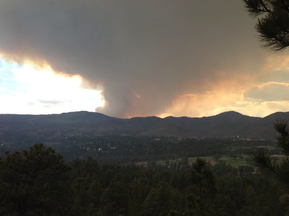
Smoke plume billowing above Pajarito Ski Hill (Tuesday evening, June 4; Steve Black photo)

On Friday (May 31) a downed power line started a wildfire in the west-central region of the Jemez Mountains near a deep drainage called Sulfur Creek on the western margin of Redondo Peak.  The fire burned uphill on the eastern side of the drainage rapidly, and was named the Thompson Ridge Fire (although not on Thompson Ridge).  The sight of smoke in the Jemez was visible in Los Alamos by 5 pm and the entire town held their breath, thinking “here we go again”.  By Saturday afternoon smoke from the plume began to collapse on Los Alamos, and the smell of burnt pine caused an even stronger visceral reaction triggering memories from June 2011 when the Las Conchas Fire swept around the town, led to a week-long evacuation, and charred more than 150,000 acres.  The question on many peoples’ minds is “why?”  It certainly seems that the entire Jemez is going to be soon burned, leaving a high elevation desert.  The 1996 Dome fire, the 2000 Cerro Grande and the 2011 Las Conchas Fires have changed the scenic vista of the eastern Jemez profoundly and probably for hundreds of years.  Each of these fire was bigger than the last:  The Dome fire was 16,500 acres, Cerro Grande was 48,000 acres, and Las Conchas was over 150,000 acres.  The obvious question is “are the fires getting bigger and more frequent?”

Image

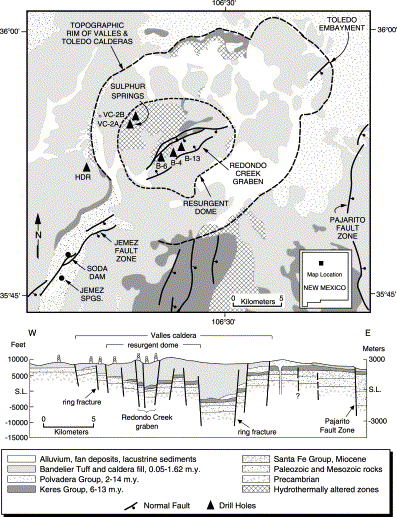
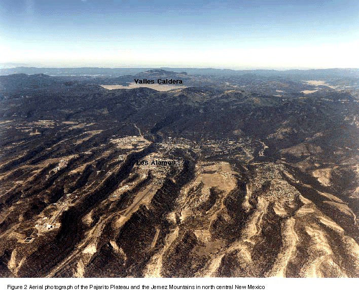
The Jemez Mountains are a unique alpine island created by the Jemez Volcanic Complex (JVC) that was active for about 800,000 years beginning around 1.4 million years before the present.  The JVC lies along a line of volcanoes that arcs across New Mexico from the southwest to the northeast, known as the Jemez Lineament.  In the southwest the San Carlos Volcanic Field (in Arizona) anchors the Lineament, and it passes through Mt Taylor near Grants, the Jemez, and finally terminates in the Raton Volcanic Field.  There is no real good explanation for the Jemez Lineament, and geologists continue to debate both its cause and significance.  The JVC is the largest of the volcanic fields on the Lineament.  The geologic map above shows the Jemez Mountains.  The Jemez Mountains surround the Valles formed during the collapse of the JVC about 1.1 million years ago.  In the middle of the collapse crater a great “resurgent dome” was pushed up by the death throes of a great volcano.  This dome is Redondo Peak – which is not an eruptive volcanic cone, but an extruded dome.  Redondo Peak is the high point in the Jemez at 11,258 ft elevation.  The uniqueness of the Jemez was recognized by the first geologic expeditions of the west; John Wesley Powell himself visited the Jemez in the 1880s and described it as a giant volcanic field (anyone interested in the geology of the Jemez should read Fraser Goff’s book “Valles Caldera: A Geologic History”).

The volcanic field and Redondo rise above the surrounding New Mexico highlands to form a roughly circular mountain range.  This range has its own flora and fauna – or at least it did before the great fires of the last 25 years.  Elevations above about 7200 feet were dominated by ponderosa pine and various fir and spruce.  After a fire the pine is replaced by scrub oak and lower growing vegetation. Craig Allen has studied the fire history and vegetation of the Jemez, and has found dramatic change.

Image

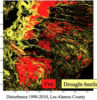
This change is from both fire and mortality of the pine forest due to prolonged beetle attacks.  The figure above shows a color-coded map of the Pajarito Plateau, centered on Los Alamos, and where fire or beetles have affected our forests.  In twenty years 90% of the forest have been subject to stress.

The question of “why” is the Jemez burning can be partially answered by looking at the fire history of the mountains.  There are various ways to do this, including coring trees looking for scars from ancient fires, and looking at the peats in the meadows within the Valles and looking for preserved ash and charcoal layers.  When Allen and other researchers did this they reconstructed a fire record that stretches back nearly 10,000 years.  There are literally tens of thousands of fires over this period, and some strong trends are worth noting in the last couple of hundred years.

Image

The figure above shows the location of nearly 5000 fires in the 20th century, along with the Cerro Grande Fire.  The great bulk are small, local wildfires, probably almost always caused by lightning. There is evidence in the distant past of very large fires – probably as large as Las Conchas – all across the Jemez. There is a moderate correlation with those large fires and large-scale drought. However, before the mid-20th century wildfire was most commonly characterized by small, frequent fires.

Beginning in the late part of the 19th century man began to have a significant impact on the ecology of the Jemez.  Livestock grazing in the Jemez became “big business” and the removal of the understory grasses probably suppressed wildfire.  The cows and sheep ate the grasses that supported spreading the fires.

Image

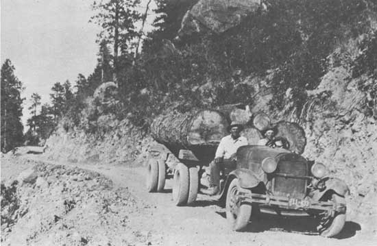
In the 1930s the Jemez became a lumber supplier, and the region began to be heavily logged.  This is particularly true for Redondo Peak and the Valles Caldera which were in private hands, and were not subject to the regulation of the Forest Service.  The picture above shows a logging road from the mid-1930 on the northwestern side of Redondo.  Today, logging roads are still seen across the Jemez, especially as spirals up the various domes.  The lumber “boom” ended, and the forests began to fill in.  Livestock grazing dropped dramatically, and new Federal oversight of wildfire suppression caused the forest cover to densify.  By the 1960s the forests were much more dense then 200 years previous.  The pathways for fire were increasing.

Over the last 2000 years there have been periods of drought and high precipitation.  Around 1990 we entered a period of drought, and the window between 2000-2010 was likely the driest decade in a millennium.   This drought stressed the trees, and they became much more susceptible to disease.  In particular, the pine bark beetle attacked, and will eventually kill, more than 1.3 million acres of ponderosa pine in New Mexico and Northern Arizona in the period of 2002-04.  The beetle problem is complex – stressed trees are one issue, but also the density of the forest allows the beetles to spread much more rapidly than in the past.

Image

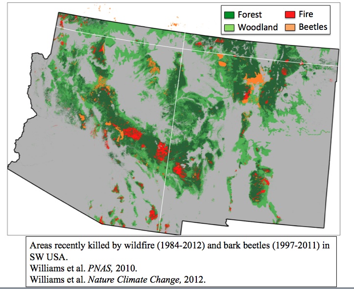
Nate McDowell and colleagues at Los Alamos produced the figure above that shows the loss of forest due to the beetles and fire.  It is fair to say we are in a long-term, profound, change of our forest.  The Jemez is not unique, but it does seem to be at the confluence of disease, drought, forest “management” and finally, the encroachment of man.  Before 1950 the vast majority of wildfire was caused by lightning.  However, since 1990 more than 85% of fires have a man-made fingerprint.  For the four major Jemez fires in the last 25 years it is all man-made;  The dome fire was caused by a camp fire, the Cerro Grande started as a controlled burn (what a total fiasco – and to this day an unpunished event), Las Conchas was started by a downed power line as was the present Thompson Ridge.

Image

Although it is dangerous to predict the fate of nature, it certainly seems that large fires are going to continue in the Jemez for years to come.  A break in the drought would help, but a short break would only promote the understory growth which would become the match stick once drought resumed.  We are standing on the cusp of a major change for our beloved Jemez, and can only hope that luck and nature conspire!

The Jemez Trail Run: A good run gone long

In every walk with Nature one receives far more than he seeks – John Muir

Image

Los Alamos is my home; I grew up in this town perched on flat mesas dissected with steep canyons cut in the volcanic tuff by a million years of rainstorms.  I loved the mountains of the Jemez and the thick forest of ponderosa pines, and I loved the town populated by special and odd people.  In the 1950s and 60s the town was “science USA”, and nearly everyone was an “outdoor buff”.  I moved when I graduated from high school in 1974, got my academic degrees, and went on to a 20 year career as a professor at the University of Arizona – but I always yearned for home. I was fortunate to have the opportunity to return a decade ago, and love my town more than ever.  It has changed – gotten lots older (people and homes), the lab is different, and the landscape has been ravaged by two horrendous fires (first in 2000, and then again in 2011 – both were the largest fires in New Mexico history at the time).  But the geology is the same – the high mountains are the rim of a super volcano that erupted and collapsed into a series of calderas during episodic activity 1.5 mya to about 600,000 years ago.  Los Alamos is built on the pale volcanic rocks that were erupted around the caldera;  these rhyolites were laid down like a snow fall building a large flat plain which we call the Pajarito Plateau today.  This Plateau has been eroded so there are a series of mesas and canyons giving the landscape a rugged feel.  It is through these canyons and mesas, and beyond to the rim of the caldera that the Jemez Trail Run is conducted every May.

I decided to participate in the 50 km version of the Trail run last December (2012). I have always loved to hike and bike but I was not a runner.  In 1998 I received an artificial hip on my left side, and in 2009 I received an artificial knee in my right leg.  Strong instructions from everyone – do not ever run!  But life caught up with me.  In 2011 both my parents, Los Alamos residents, died.  The 2011 Las Conchas fire roared across the Jemez mountains in late June and burned more than 150,000 acres of our beloved pine forest.  I gained weight and was not particularly happy.  So in 2012 I decided to reconnect, and running through the mountains was a big part of that.  By the time the Jemez Trail Run was open for registration I was on the path to adventure.  When May 25 rolled around I was ready for the 31 miles with nearly 7000 feet elevation gain! Until I read the weather report, and it was going to hot, very dry, and windy – I don’t like hot!

Image

Trail map – the course starts/ends at the bulls eye, and the red line is the 50 km course.


Running the Jemez Trail Run 

The Jemez Trail Run has three races – a 50 miler, and 50 km, and a half marathon.  All are in the Jemez, mostly single track, and all have at least one horrendous climb. All the races start on one of our mesas – in this case on North Mesa at an historic building called the Posse Shack.  The 50 milers start in the dark at 5 am;  the 50 km folks start at 6 am, but most are checked in and ready for action by 5:30.  I was quite excited and ready to go – I was geared up with water bottles, gels, energy bars, my trusty garmin watch, and most importantly, my lucky hat.

The race is put on by locals that devote a tremendous amount of time and effort.  The race support is absolutely first class, and the aid stations are certainly better than most school cafeterias!  Everyone  was supportive, and certainly everyone had advice for me.  “Don’t go out too fast”, “triple the amount of electolytes you think you need”, “walk every hill!”, “EAT”, and so on.  I appreciated the advice, but I had a plan – I had covered the course numerous times in the last 5 months and had figured the pace for every single mile I needed to make a time of 8 hr 30 minutes.  That is not a great time, but it was something I though I could do.  My back ground is theoretical science, so it is fair so say I had analyzed everything I could, but lacked practical experience…..

Image

Tom Stockton (the Race Director!) started the race – all the runners were ready, but sort of chaotic.  Tom wandered to the front and asked “Is everyone ready to go?” That was met with a nervous “sure” from the nearly 200 runners. So Tom said “Okay, go”.  That was it – suddenly everyone was running and I was picked up in the laminar flow, not really sure how to execute my plan.  Mile 1 drops down off North Mesa into Bayo Canyon.  It was fast – I was running a 9:30 minutes/mile pace which was not to plan.  The dust from the faster runners hung in the air like a fog.

Image

I felt comfortable, and tried to ease back into a 12:30 pace that I had planned.  The first aid station was a mile 5, and I felt great – ran right past the station, sucked down a mocha power gel, and started thinking about how easy this was actually going to be!

Image

At mile 7 the course is running the Perimeter Trail only a few hundred yards from my house.  I had a quick flash that maybe I should just go home, but I was feeling way too good.  The first difficult part of the course is a very steep and slippery descent into Pueblo Canyon, and steep ascent, and then a steady climb for a mile up a small mestia of rhyolite called Quemazon Mesa (appropriately named – translates as “big burn” and it did burn in 2000).  Finally this drops back down into Los Alamos Canyon at near our local ice skating rink.

Image

The elevation at the bottom of the canyon is 7200 feet and change.  Now the run, at mile 8 or so, really begins.  The next 7 miles is a climb of about 3200 feet. After climbing the 250 feet out of Los Alamos Canyon the trail heads toward Pajarito Mountain and our local ski hill.  The climb starts steady, but at mile 9 it runs into a cliff a couple of hundred feet high.  This is the scarp of the Pajarito Fault, and dominates the lower Los Alamos landscape.  I was definitely walking the Fault!  Finally, at the top of the scarp is the second aid station – 10.6 miles into the race.  The food there was a godsend, and I drank like a camel at the oasis in the desert.  I was still feeling pretty good, and thinking I was right on course with a time of about 2 hrs and 10 minutes for 10.6 miles.  I knew the next portion was a grind, but I was thinking perhaps I was actually a runner!

Image

A couple of miles beyond the aid station the trail breaks out into a flatish region known as “Geist Gap” (after one of the many great Los Alamos runners). This section was burned both in 2000 and again in 2011, and the land scape is barren.  There is still soot on the trail, and the sun beats down on you in full glory.  I began to wilt, and wondered if some how I had eaten something bad at the last aid station (no way was that true, but my energy was draining fast).

Image

Geist Gap intersects the Pajarito Ski Hill at about mile 13 at an elevation of 8,800 feet.  Here the trail becomes both spectacular and sinister.  The trail is wonderful single track that is not rocky, and soft with matted vegetation.  However, over only 2.5 miles the climb is 1,600 feet.  I had practiced this climb many times, and was sure that I was prepared – but I was wrong!  The climb took me over an hour, and when I peaked out on top of Pajarito Mountain I was exhausted.  The view from the top is spectacular, but I don’t really remember it at all.  The descent to the ski lodge and aid station 3 is steep, and should be swift.  It was just steep.  I stumbled into the 17 mile aid station at 5 hrs and very tired.  My wife was there waiting and giving me support, and the aid station was enormous – filled with all sorts of food and drinks.  I refilled my water bottles, ate what I could (my stomach wanted nothing to do with the food), and drank cold water.  Finally, my wife dosed me with ice water, which is probably the single best thing that has happened to me in a year.  My core began to cool, and I decided that I could make the last 14 miles easy.  I grabbed some food, and decided to walk a couple of miles to regain my composure.

Image

It is a lovely walk from the Ski Hill through a large meadow that is called Canada Bonita.  This is where we locals snow shoe in the winter – no sign of snow now though.  I began to feel much better and actually began to pass people even though I was walking.  About 3 miles from the Ski Hill is the fourth aid station – known as the pipeline station after the road that was built to bring a natural gas line into the Lab back in the 40s.  This aid station was manned by the Los Alamos High School cross country team, and I was feeling good enough to eat and chat about the end of the school year.  I knew it was almost all down hill from here, and only about 12 miles.  Anyone can go 12 miles I thought.  When I say “almost” all down hill, the almost is because there is one ugly climb, locally known as “kick-ass hill” that is about 300 ft high in less than a third of a mile.  Today though, kick-ass was no problem.  Climbed that devil and was flying down hill towards home!  Now, by flying, I mean I was holding a 13 minute per mile pace.  But I felt great.  This section of the course descends the Guaje Ridge trail.  It is a beautiful trail, but the ridge was ravaged by both fires.  After about mile 23 there is no vegetation except scrub.  Charred stumps of formerly mighty pine litter the mountain side.

Aid station 5 is at the intersection of Mitchell Trail and Guaje Ridge Trail.  The folks that run the ½ marathon run up Mitchell Trail, and then back again along Guaje ridge.  It is a heck of a challenging 13.1 miles, and I am shocked when I see the winners can do it in a little over an hour and a half plus change.  Most of the runners take more than 2 and a half hours.  I fill up at this aid station only 7 miles from the finish.  I am confident, but I can’t seem to cool off.  I drink lots of water, refill my bottles, and dose my head.  I take off at a good pace – down to 12 minutes a mile, certain that I will make a time of 8 hrs and 18 minutes (I have done this before so I know that answer!  I was wrong).  The sun is beating down on me, and I realize that the humidity is probably in the single digits.  I drink every 5 minutes.  Even though the course is down hill my pace begins to fad.  About 3 miles from the finish, and 1 mile to the last aid station, I stumble and as I catch myself both of my legs cramp in the upper thighs.  The pain is intense.  I stop and massage my thighs – everything is slowly relaxing, so I can begin a waddle down the trail.  Carefully, I ramble into aid station 6, and eat some of the best tasting watermelon I have ever had.  Only 2 miles to go – and I have run this part of the trail dozens of times.  I start in a walk, and slowly ease into a shuffle.  I am cooking now – cruising at a 15 minute per mile pace.  I am almost there!  The last 1/3 of a mile is a climb back up North Mesa along a trail carved in the soft rhyolite.  The trail is really a deep rut – in some places the rut is 3 feet deep and only 15 inches across.  In the middle of this climb my legs cramp – crap, I am stuck in the rut and can’t move!  This is terrible – what if I have to be rescued from the rut!  Mustering all the Zen I can imagine, I relax my legs and slowly finish the climb.  I cross the finish line a little under 8 hrs 36 minutes.  My wife this there, as are many of my friends that are actually runners or athletes.  All offer congratulations, but I just grunt and head for the ice water coolers.  9 cups of water later I am starting to realize that I did survive.

Image

I am joyful for the experience, and loved every minute of the run.  Los Alamos is blessed with people to make this even happen – the town is filled with trails for running, and the community takes care of all this.  Although it was not particularly easy, I am happy.  Now I have to get on my bike and ride the Tour de Los Alamos in two weeks (I wish I had ridden my bike in the last three years….but that is a new adventure).