The Riff of the Rio Grande Rift: Running in the Pecos Wilderness and up Santa Fe Baldy

Both the man of science and the man of action live always at the edge of mystery, surrounded by it – J. Robert Oppenheimer, who was appointed the Director of Los Alamos Laboratory in November 1942.

stormoverSangre.post

View of a late spring storm over the Sangre de Cristo mountains viewed from Los Alamos (photo by Jim Stein, Los Alamos photographer extraordinaire, May 26, 2015). The peak in the center-left is Santa Fe Baldy (elevation 12,632 feet).

The town of Los Alamos sits high above the Rio Grande River on the Pajarito Plateau.  The location of the town will always be associated with the Jemez Mountains and the spectacular Valles Caldera; however, the view from the town is always to the east, across the Rio Grande Rift, and towards the Sangre de Cristo Mountains.  The Sangre are the southern most range of mountains that are part of the Rockies, and the view from Los Alamos is dominated by a series of rugged high peaks – Truchas, Jicarita, Sante Fe Baldy Peaks all top 12,500′ – these rocky spires guard the Pecos Wilderness, one of the Jewels of unspoiled New Mexico.

The creation myth of the Los Alamos often casts J. Robert Oppenheimer as selecting the isolated and rugged Pajarito Plateau for the project Y laboratory because of a connection with the Los Alamos Ranch School, a boy’s college prep school. However, that is incorrect – indeed, Oppenheimer recommended and lobbied for a laboratory in New Mexico because of his affection for the area.  But that attachment was with the area that would become the Pecos Wilderness Area.  In 1922 Oppenheimer and his brother Frank visited the Pecos Valley and loved it – so much so, that the brothers first rented, and eventually bought, a ranch along the Pecos River which they named “Perro Caliente” (the legend is that when Oppenheimer found the land for sale he shouted “hot dog”, and the name seemed logical for the new ranch).  When General Groves and Oppenheimer visited New Mexico to locate project Y the preferred site was near Jemez Springs.  However, Oppenheimer convinced Groves that the high cliffs would make the scientists claustrophobic, and thus, unproductive.  The next site visited was the Los Alamos Ranch School, and Oppenheimer beamed with joy at the view towards the Sangre de Cristo mountains, and exclaimed that the scientists would be inspired by the vast vista.  Of course, to the is day, the scientists — at least this one — remain inspired by the magnificent mountains.

attheranch

J. Robert Oppenheimer and E.O. Lawrence at the Oppenheimer Ranch along the Pecos River in the Sangre de Cristo Mountains. Oppenheimer often rode a horse from his ranch up to Lake Katherine just below Santa Fe Baldy.

The high mountain peaks of the Sangre are accessible by a number of trails that are only 35 miles from Los Alamos.  These trails allow great entry into the high country for trail running (and hiking!); several of the trailheads are located at the Santa Fe Ski Basin, and are gateways to runs of 20, 30, and even 50+ miles at elevations that never drop below 10,000′. This is a perfect training ground for the ultras like the San Juan Solstice 50 Miler (June 27, only 2 weeks away) — so off went about 10 runners from Los Alamos and Santa Fe on June 13 to get some quality high altitude climbing and descending, and tasting the ever changing alpine weather.

Zerkle.done

Dave Zerkle, at the Sante Fe Ski Basin after a wet run up Santa Fe Baldy.

The geologic story of Santa Fe Baldy

New Mexico is an arid state. In fact, it has the lowest water-to-land ratio of any of the 50 states in the US, and more than three quarters of the few lakes that exist are actually man made reservoirs. Despite this lack of water, or perhaps because it is so scarce, the human history of the state is dominated by a narrow ribbon of water that bisects New Mexico, the Rio Grande River.  The Rio Grande is long, but not wide, and only in New Mexico would the name “Grande” be applied to this river.  The stream gauge at Otowi Bridge — on the hiway route from Los Alamos to the Sangre de Cristo Mountains – read 2500 cubic ft per second the morning of June 13, 2015 (the Mississippi River flow was 220 times larger at St Louis this morning).  However, this modest flow supports the state, and 75 percent of the state’s population lives within 50 miles of the Rio Grande.

The Rio Grande River is also a remarkable geologic marker. The headwaters are in the San Juan Mountains of Colorado, and entire course of the river through New Mexico follows a topographic depression that traces the Rio Grande Rift (RGR).  The RGR is relatively uncommon geologic phenomena, a continental rift (there are only three others in world), and it represents a stable continental plate slowly being torn apart; or more correctly, stretched apart.  The RGR stated about 25-30 million year before the present, and represents the end stages of extensive crustal extension throughout the southwest. The crust between the California-Nevada border and the Tucson, Arizona extended by as much as 50% during this time. The RGR is presently opening at less than 2 mm per year, but integrated over millions of years this has created a “hole” where the crust has been stretched apart. This hole is instantiated by a series of basins that have been filled with the sediments transported down the Rio Grande River.

Basins

The trace of the Rio Grande Rift is marked by a deep graben, which is mostly filled with sediments that have washed down the Rio Grande River over the last 25 million years. Los Alamos sits on the western margin of the Rift, and the Sangre de Cristo Mountains are along the eastern margin. Between Los Alamos and Sante Fe Baldy is the Espanola Basin.

The figure above shows the largest of these basins, including the location of the Espanola Basin which sits between Los Alamos and Santa Fe, and is more than 10,000 ft deep and filled with ancient river sediments.  The flanks of rifts are almost always elevated relative to pre-opening of the rift.  This may seem counter intuitive given that the opening of the rift creates a “hole”.  However, the opening of the rift is usually associated with ascending hot mantle material, which “lifts” the region overall.

riftdynamics

Conceptional cartoon for continental rift dynamics. Ascending hot mantle materials raise the elevation, and as the crust is extended a rift valley forms. The flanks of the rift are often uplifted high mountains with steep faces sloping into the rift valley.

This is the case for the entire eastern flank of the Rio Grande Rift in northern New Mexico.  The present topography of the Sangre de Cristo Mountains owes its existence to the opening of the RGR.  The Sangres are an ancient mountain range and certainly were part of a proto-Rocky Mountains.  However, studies of erosional surfaces indicate that 35 million years ago the prominence of the Sangres was only a thousand feet.  Opening of the rift allowed the rocks of the range to rise to their present elevation and develop and prominence of over 7,500′.

pecosmapRobertsonMoench1979

Geologic map of the Pecos Wilderness Area. The western margin is a block of plutonic granitic rocks that have been uplifted during the opening of the Rio Grande Rift. This block contains all the high peaks of the Sangre de Cristo range (from Robertson and Moench, 1979).

The core of the Sangre de Christo Mountains in the Pecos Wilderness area are Precambrian plutonic granites (and granitic gneiss).  In the figure shown above, the large elongate block on the western side of the map shows the extent of this plutonic rocks which are approximately 1.6 billion years old.  They are fragments of the original North American crust that were probably formed 5 to 10 km beneath the surface of the Earth.

The topography from the Jemez Mountains to the Sangre de Cristo Range are due to the dynamics of the Rio Grande Rift.  In fact, the entire landscape of the New Mexico has been influenced and shaped by the RGR.  As a geologic architect, the rift is Frank Lloyd Wright.

lookinguptobaldy

Looking up at Santa Fe Baldy from the Winsor Trail just beyond the Rio Nambe crossing. 2000 feet to climb in about 2.5 miles. Steep and sweet.

Sky running in the Sangre 

The Mountain Trail Series group (meaning Dave Coblentz from Los Alamos) organized a trail run for the high country of Pecos Wilderness.  The run (route shown below) climbed several of the peaks, and included some cross-country (no trails).  Several of the less ambitious (I am actually always ambitious, but my athletic ambitions do not match my actual skill) chose to run a section of the course.  The IDEA was to run up Santa Fe Baldy and then loop back over Lake Peak.

Coblentz.map

Map of the “course” for Beyond Baldy, a Mountain Trail Series Event. A group of us chose a slightly less ambitious versions that topped Santa Fe Baldy and Lake Peak without venturing cross country to Redondo Peak.

The forecast called for rain, but gave a glimmer of hope that the precipitation would hold off until noon.  However, at the start of the run at 7 am it was clear that a storm was brewing.  The Winsor Trailhead has an elevation of about 10,200′, and that is the low point of the run. The trail starts with a steep, switchback climb – about 500 feet in the first half mile – and by the top of first segment the fast runners have baked me off the end of the group.  This is good because it gives me time to look at the rocks and not feel pressure.  The trail is soft and not particularly rocky, but there are ample outcrops to see large blocks of granitic gneiss/schist glistening in the morning light.  The schist is rich in mica – and it is a marvel to imagine that this delicate mineral could last for over a billion years!

Once the trail enters the Pecos Wilderness boundary it is fairly flat for about 4 miles.  Easy running, along with a couple nice stream crossings.  When you arrive at the Winsor-Nambe trail fork the serious business of climbing begins.  However, today is a training run, so the pace is steady and easy. About 1/2 hour from the summit of Baldy we can see the fast runners along the ridge nearly to the top.

terryontop

Standing on the summit of Santa Fe Baldy. Behind me is the silhouette of Truchas Peak and ridge, about 30 miles north. There is no sunshine this June morning.

The views from the summit of Santa Fe Baldy are usually breathtaking.  However, today, hanging clouds at the front edge of a storm surround the ridges and obscures any distant vistas.  There is a fine view down to Katherine Lake, which still has some ice!  Lake Katherine is within a cirque on the northeast side of Baldy.  This cirque was formed by alpine glaciers that were extensive about 11,000 years ago.  Based on the number and character of the cirques on Baldy and Lake Peak the annual average temperature of the region must have been about 10 degrees F less than today. Katherine Lake is the largest alpine lake in the New Mexico (although small), and has an unbelievable connection to J. Robert Oppenheimer – he named it.  The lake is on maps that were produced before 1930 with no name, but in 1933 a map was produced that included the name “Katherine Lake”, and a reference to Oppenheimer as the namer.  It turns out that on J. Robert’s first visits to Pecos he became infatuated with a young woman of an old New Mexico family, Katherine Chaves.  His affections were apparently unreturned (it would appear that Oppenheimer was a nerd as far as the opposite sex was concerned, and he may have never even approach Chaves), but on his many trips riding horses in the Pecos came to love the small lake beneath Baldy, and wistfully named it Katherine Lake.

lookingatkatherine

a view from Santa Fe Baldy down to Katherine Lake. There was still a thin covering of ice on most of the lake, extremely unusual for June!

After a short break at the summit it was clear that it would soon start storming, and we began the descent down Baldy back towards Lake Peak.

zerkle

Dave Zerkle on the flank of Santa Fe Baldy. Over his right shoulder is Lake Peak and the cirque that contains Nambe Lake.

Soon there was grapple falling – then hail – then rain – then hard hail.  All those things are just an enjoyable part of trail running.  However, they were accompanied by thunder and lightning, and it was prudent to get off the exposed ridge lines as fast as possible. At this point I am reminded that being an old, slow runner has advantages – feet close together makes for less potential drop during a close-by lightning strike!

lightning

Most lightning fatalities are NOT from direct strikes. Rather, they are from close by strikes and the fact that humans make a grounding loop. Strangely, if your feet are together the potential drop from one foot to the other is much lower than if you have a wide stance….So, run with a shuffle.

The down pour dictated a change of plans, and we had to delay the run up to Lake Peak for another day.  Nevertheless, the run up Baldy is a great adventure!

moonrise

Moonrise over Santa Fe Baldy seen from Los Alamos. Another outstanding photo from Jim Stein. Full moon, mid-April, 2015.

The 10th Anniversary of the Jemez Mountain Trail Run: Surviving or thriving during a mountain ultra run

One thorn of experience is worth a whole wilderness of warning, James Russell Lowell, 19th Century American Poet

LosAlamos.morning

Sunrise in Los Alamos, New Mexico a few weeks before the running of the Jemez Mountain Trail Runs.

The May 23rd running of the Jemez Mountain Trail Runs marks the 10th anniversary of a wonderful group of trail runs hosted by the High Altitude Athletics Club and staffed by a most enthusiastic group of volunteers. 50 miles, 50 km, and a very “heavy” ½ marathon bring 600 runners to be challenged by steep climbs and descents traveling along the volcanic ruins of a magnificent caldera complex around Los Alamos, New Mexico. In the decade since the event was conceived as a modest local ultra event, much has changed in the world of long distance trail running; but the original goal of the JMTR – celebrating the joy of running in the mountains, is very much in evidence in Los Alamos in late May 2015.

Los Alamos has always been a unique community.  It is best known as the home of Los Alamos National Laboratory (and indeed the community would not exist without the Lab), and has a high concentration of world class scientists and engineers;  however, there are other national laboratories spread across the country, and it fair to say that in many ways the residents of Los Alamos are rather different. I grew up in Los Alamos, went away to be an academic for two decades, and had the privilege to return 13 years ago and work at the Lab.  There is a character to the town and it’s residents — lab employees or not — that embraces the rural mountain lifestyle.  People here love the outdoors and in general, they are likely to run, bike, hike, camp, hunt, swim, ski – most anything that celebrates nature.  The Jemez Mountain Trail Run is a good example of this romance.  The German website Deutsche Ultramarathon Verengung (DUV) tracks statistics for ultra trail runs, and although there is no doubt that some races are missed, it is a good measure of worldwide ultra (50 km races and beyond) participation.  In 2014, 34,954 Americans (unique names) ran in ultras.  There are 200 million adults in the US (between ages of 18 and 65);  assuming all adults could run an ultra, only .0175 percent of this population choses to do so.  The adult population of Los Alamos is approximately 12,000, which would imply that if the town was “like” the rest of the US, then about 2 of the residents would run an ultra.  In fact, in 2014, 49 Los Alamos residents ran at least one ultra — DUV and Ultrasign report that Los Alamos residents ran no less than 71 ultras, including 5 or 6 runners that entered and finished 100 mile races.  Applying bulk statistics is always fraught with danger, but it is clear that there is much Jemez love for being on the trail for long periods of time!

may21_27

Aaron Goldman, the force behind the original Jemez Mountain Trail Run in 2006. Photo from Sue Norwood, at the pre-race dinner in 2009.  Goldman passed away a short time before the 2010 JMTR.

In 2006 Aaron Goldman, a Los Alamos ultrarunner (and extraordinary humanitarian) called a friend Kristen Kern (coincidentally, the race director of the Valles Caldera Runs) and broached the idea of running a trail-based ultra.  There had always been a strong running community in the town, but access policies to land and roads adjacent to the 40 square miles of Los Alamos National Laboratory changed dramatically after 9/11.  This eventually spelled the end of long road races, and Goldman wanted to revive the racing scene on the spectacular trails in the adjacent Santa Fe National Forest.  Aaron and Kris thought about a 50 miler, a marathon and a long-distance relay race.  The marathon eventually morphed into a 50 km ultra, and the relay was dropped for logistic reasons (relay runners would actually have to travel further to their hand-off stations than they would actually run).  Goldman expected about 20 or 30 runners total – when he had an interview with the local newspaper to drum up support he stated “any weekend jogger can run our 50 mile course”.  The original race was successful beyond all hopes – about 100 runners started, although only 50 finished (apparently the non-finishers had not been jogging on weekends enough).  The next year there were two hundred runners, and the JMTR became a fixture.

Thecourse

The JMTR 50k course (made in 2014, so there are minor variations in 2015). The course starts and ends at the Posse Shack, on North Mesa in Los Alamos. The low point is at mile 9 at the bottom of Los Alamos Canyon, and the high point is at mile 17 on the top of Pajarito Mountain. Click on figure to make full size.

The course for the various races has changed a number of times over the decade.  The 2011 Las Conchas fire devastated much of the high country in the eastern reaches of the Jemez Mountains, and later trail improvements by the Forest Service made for an improved pathway, but the theme has always been “a couple of long steep climbs, and spending time above 10,000 elevation”.  The run(s) are wonderful because of the courses, but the most amazing feature of the JMTR are the volunteers.  A core group of more than a dozen work year long on the event, but as the the third saturday in May approaches dozens more join in;  seems there are at least a hundred enthusiastic volunteers on race day manning the aid stations, coordinating the tracking of the runners and providing first aid, staging the best ultra party at the end, and making sure that JMTR is an ultra to remember. I am both both happy running, and proud of my community as I prepare to slog the 33 miles from the Pajarito Plateau to Pajarito Mountain, and race down Guaje Ridge.

Surviving the JMTR

I have run the JMTR 50 km several times, and I run the trails that comprise the course pretty much every week. I would not rank the course as overly difficult, although it is challenging. However, most of the people that come to run the JMTR are from outside New Mexico (Texas and Colorado are state most commonly represented), and many are from home bases that are at a much lower elevation. In addition, informal surveys of the runners indicate that 15 to 25 percent identify the JMTR as their first trail ultra. In fact, this year my wife (who is an outstanding marathoner) and two colleagues from the Washington DC area ran the JMTR as their first trail ultra.  Elites and runners that routinely race in the Rockies don’t need any advice on the JMTR.  However, there are some simple things to be aware of if you are coming from lower elevation, or are a novice distance trail runner.  The single biggest issue is attitude – the race starts at an elevation of 7280′ and has a short dip down to 7190′ in Los Alamos Canyon, and tops out at 10,440′ on Pajarito Mountain.  The average elevation during the 50k is about 9100 feet (the average is determined by time spent running the different sections of the courses – the steep, high elevation climbs take a couple of hours for most runners).

altitude550

Altitude zones, and the reduction of atmospheric pressure (and available oxygen) as a function of elevation.

The largest environmental factor limiting human performance is access to oxygen. Over the range of athletic performance (from sea level to the top of Mt. Everest) the percentage of the atmosphere that is oxygen is constant (about 20% of atmosphere is O2); however, the amount of the atmosphere decreases rapidly with elevation.  At sea level the pressure of the atmosphere by definition is 1 atm.  Climb to 8000 feet and the atmospheric pressure decreases to about 3/4 of that at sea level, and thus the available O2 decreases the same amount.  The effects of decreasing O2 pressures have been studied extensively – especially after the 1968 Mexico City Olympics. Although many world records were established in events like the high jump, NO records were recorded in “endurance” events at Mexico City.  Coincidentally, the elevation of Mexico City is nearly identical to the starting line of the JMTR.  The figure below shows a generalization of performance based on the duration of a particular event.  For all runners of the JMTR the expectation is that oxygen debt will translate to a race time that is somewhere between 15 and 25 percent slower than if the JMTR was run in Orlando, Florida.  That is a huge difference, and there is no way to “change” that value.  Arrival a day or two in Los Alamos before the JTMR will allow acclimatization so some high altitude effects (like dehydration), but it has nearly zero effect on athletic performance.  It typically takes 6 weeks to adjust endurance performance, and even then the high altitude performance will be significantly reduced from expected sea level performance.  I routinely visit Washington DC at least twice an month, and I have a standard running workout that allows me to compare this elevation effect.  I run a flat 6 miles with intervals; in Los Alamos my overall pace is about 10:20/mile, and in DC it is 9:00/mile.  No fooling mother nature!  This does not really make the JMTR “harder” than sea level ultras, just slower.  Expect slow, and accept the joy of running high.

performance

Generalized athletic performance as a function of elevation (from xxxx, 1998). Click on figure to see a larger version. Very short duration races – like the 100 m dash – benefit from the lower air pressures by reducing drag. However, long duration events – like an ultra run – see performance degradation due to lack of oxygen.

There are other effects of elevation in addition to lower oxygen pressures.  The lower atmospheric pressures mean lower water content also — relative humidity is not a great comparison between sea level and Los Alamos because it takes much less water content to saturate the high altitude atmosphere.  25% relative humidity in Los Alamos translates to the water content of a relative humidity of about 15% at sea level.  In addition, the higher elevation means lower temperatures, which additionally reduces the ability of the atmosphere to “hold” water.  It is a certainty that when you run the JMTR every expelled breath will contain much more water than the return inhaled breath.  The dry air has the advantage that sweat evaporates quickly, and it is easier to stay cool.  However, this also leads to dehydration – drink much more that you are use to!

Another effect of altitude is the intensity of UV radiation, the cause of sunburn.  The strength of UV radiation is directly proportional to the amount of atmosphere the photons pass through (UV is mostly absorbed by ozone).   The UV index is a standardized scale that relates UV intensity to “time to sunburn” for an fair-skinned person (the scale was invented in Canada, where fair skin = alabaster).  On a clear, sunny day the UV index at sea level might be a value of 8 — at 9000 feet a similar sunny day would have a UV value of 12.  The value of 12 translates to expected sunburn within 10 minutes for unprotected and exposed skin.  Sun screen is a must for the JMTR!

costofhill

The energy cost of climbing a hill — both running and walking.

The final challenge of the JMTR is the steep climbs – and to some extent, the fast descents.  The figure above shows the energy cost for climbing a hill (the y axis is Joules per kg-minute, and x axis is the gradient, as measured in feet climbed divided by horizontal feet traveled).  The graph shows two sets of curves – one for walking (Cw) and one for running (Cr).  The biomechanics of running and walking are different, and the energy cost of running is higher – it takes twice as many calories to run a minute as it does to walk a minute.  A gradient of 20 percent (~climbing 1000 feet in a mile) takes twice as much energy as compared to running a flat course.  Between mile 13 and 17 on the JMTR the gradient is approximately 10 percent, and the energy penalty is 50%!  This will tire even seasoned runners.  Although relative penalty for walking is about the same (50%), the energy used while walking is much lower, and therefore, walking some or most of this this long ascent of Pajarito Mountain will significantly increase your energy reserve for running the last section of the JMTR.  By the way, there is a slight energy penalty associated with running downhill also due to the pounding motion on the legs.  However, this is small – the body is most efficient running down a 10% grade.

summitpajarito

I have much experience in walking the race course to the top of Pajarito Mountain – over a dozen races along this course has taught me that power walking a few miles improves my overall race time significantly. Picture from the 2014 Pajarito Trail Fest on a beautiful fall day.

All the best advice for running any ultra can only go so far.  On race day many factors – health, sleep, injuries, etc. will actually determine the outcome.  I was reminded of this lesson this year – flu like symptoms and dehydration forced me to drop the JMTR at the 18.2 mile point.  It was my first DNF in an ultra, but it was clear that my body was not in tune with my hopes!  All ultras are a struggle, and runners go through physical and mental cycles of feeling well.  Sometimes the troughs are deeper than the crests.

Trying to run the 2015 JMTR

The starting and ending point for the JMTR is a historical log-cabin known as the “Posse Shack”.  The Los Alamos Sheriff’s Posse – a group of equestrian enthusiasts for the most part – built the shack as a meeting place and social center in 1958.  The Posse Shack is located on North Mesa (although many locals call it “Horse Mesa” because of the stables), one of a dozen mesas that make up the Pajarito Plateau.  The mesa is an erosional remanent and is composed of Bandelier Tuff – volcanic ash that was erupted in two mega eruptions about 1.4 million years before the present from volcanic vents that were above the Valles Caldera.  The tuff was laid down as a hot ash cloud, and “welded” by internal heat.  Despite the moniker of welded tuff, the rock is quite soft, and easily eroded.  The course takes off due east and then drops into Bayo Canyon, and runners, hikers and horse riders of the past have carved a narrow track in the tuff.

EarlyPosse

The Posse Shack, shortly after it open 57 years ago. The modest building still serves as a gathering point for events in Los Alamos.

It has been an unusual spring in Los Alamos, and for five weeks in a row before race there has been snow and rain on the town.  This moisture is most welcome even if it generated endless discussion about the consequences for the JMTR.  Last year (2014) a noon time snow squall ended up chasing a hundred runners off the course.  However, this year the weather is perfect at race time – the temperature was 47 degrees, and there was almost no chance of rain.  I awoke at 4:00 am, but had a heart rate of 41 beats per minute.  I would love to claim that this was due to extraordinary conditioning, but alas, this low heart rate means that the lack of a thyroid is “acting up”. I fixed the heart rate by downing several cups of strong coffee – got it up to 50 by race time, but knew running 50 k was going to be difficult.  2015 has been a tough year physically for me, and the latest challenge started as a toothache about 4 weeks before the JMTR.  10 days before the race it degenerated into a full blown abscess, and I awoke to a swollen face that caused one of my eyes to be shut.  The swelling was remedied by a regiment of penicillin, and after a week (3 days before the race) my face was normal, and the tooth(s) although dead did not bother me.  However, the penicillin also killed all the useful bacteria in my digestive track.  I knew that there was a chance of dehydration during the run because of digestive issues (that is a “delicate” euphemism), but prepared for the long run.

startline

Starting line at 5:50 am, May 23, 2015. Note that the white chalk line is more like a gathering point than anything else.

The start of the 50 k is always strange.  The race director and staff are mellow, and the  “ready, set, go” is decidedly informal. However, once the start is announced the runners sprint away. Sprint!  There is 33+ miles to cover and thousands of feet to climb, but the emotion of the start catches up even the most jaded runner.  I always resist the urge to sprint – for about 10 seconds, and then I am stampeding with everyone else. As the course dips down into Bayo Canyon I always feel like a lemming that follows the pack to certain doom.

lemmings-at-the-cliff.2

The start of the 50 km race is always crazy. It very much reminds me of lemmings running as fast as they can off a cliff – no return!

The first five miles of the run is deceptively easy, and although the there is some steady climbing it is pretty easy to roll into the first aid station in under an hour.  Of course, the fastest runners have past the aid station in 45 minutes or less, so the field of runners is spread out. I arrive at the aid station at 55 minutes, but I am not feeling great.  Fortunately, for the next 10 miles or so I have great company and discuss everything from basketball to lab politics.  Mile 9 really defines the beginning of the JMTR – that is the low point elevation wise in Los Alamos Canyon.  Over the next 9 miles the climb is steady and unrelenting.  Conversation makes the miles seem pretty easy, and we arrive at Aid Station 2 (10.2 miles) about 2hrs and 15 minutes from the start.  That time is 10 minutes slower than I have ever covered on this course, but does not seem alarming yet.

Right before the aid station there is a very tough climb – short, but steep.  It is associated with the scarp of the Pajarito Fault.  The fault is related to the Rio Grande Rift and has been active (at least in a geologic sense) for at least 5 my.  The offset of the Bandelier Tuff approaching the aid station is 100m. This short climb sends alarm bells off in my head about my state of health.

dacite.geology

Once Aid Station 2 is passed, the trail is out of the Bandelier Tuff, and the rocks become much harder and angular.  For the next 8 miles the geology is dominated by grey dacite – there are little white flecks of plagioclase, and sometimes you can find tiny biotite crystals. Today the rocks just seemed grey. The dacite was not formed by a massive eruption, but by a series of lava flows and injections of dikes.  The map above shows the Pajarito Mountain Dacite, and the surprising location of a 3 million year old vent that extruded the dacite.  Yes, Pajarito Mountain is an ancient volcanic vent, and that vent is located just east of high point of the JMTR.

Although I am feeling punkish, we are making pretty good time on the trail.  By mile 14 we still only 10 minutes off my typical pace.  However, I have to get off the trail fast here – I urge my companions on, and by the time I am able to resume the run I am far behind.  Unfortunately, no amount of water drinking can cure the stomach maladies that now have me in their firm grip.  By the time I top out near Pajarito Mountain, I have no real control over my body.  I usually love the run from the mountain top down to the ski lodge – a drop of 1200 feet in 1.3 miles – today I am limited to a slow trot.  I make it to the ski lodge in 5 hours, but I make the very painful decision that I have to drop, and declare a “Did Not Finish”.

Only 18 miles covered on the 10th Anniversary JMTR.  Bummer.  However, the incredible volunteers at the ski lodge aid station have me pseudo hydrated soon after I drop, and arrange a ride for me back to the Posse Shack.

The JMTR was a great event despite my pitiful journey.  I was most fortunate to have a couple of guests in my home that traveled from Washington DC to race in the JMTR.  BethAnn Telford is an amazing and inspriational woman – she was diagnosed with brain cancer in the Winter of 2005 and has dedicated her life to raising awareness of the illness and constantly inspiring others that suffer from this killer.  BethAnn is an amazing runner and came out to experience the JMTR as training for a Rim-2-Rim run this October to highlight HOPE that no disease should stop the joy of life.  With BethAnn was a young woman, Sarah Domnarski, that is a running partner.  My wife ran with BethAnn and Sarah for their first ultra, and they were far more successful than I.

IMG_0368

The HOPE team at standing in front of the JMTR quilt honoring ten years of running in Los Alamos Mountains. From left, Michelle Hall, Sarah Domnarski, and BethAnn Telford.


Climbing the Great White Whale: Mt. Rainier and marveling plate tectonics

Each volcano is an independent machine—nay, each vent and monticule is for the time being engaged in its own peculiar business, cooking as it were its special dish, which in due time is to be separately served – Clarence Dutton, American Pioneering Geologist, 1880.

rainiersept9

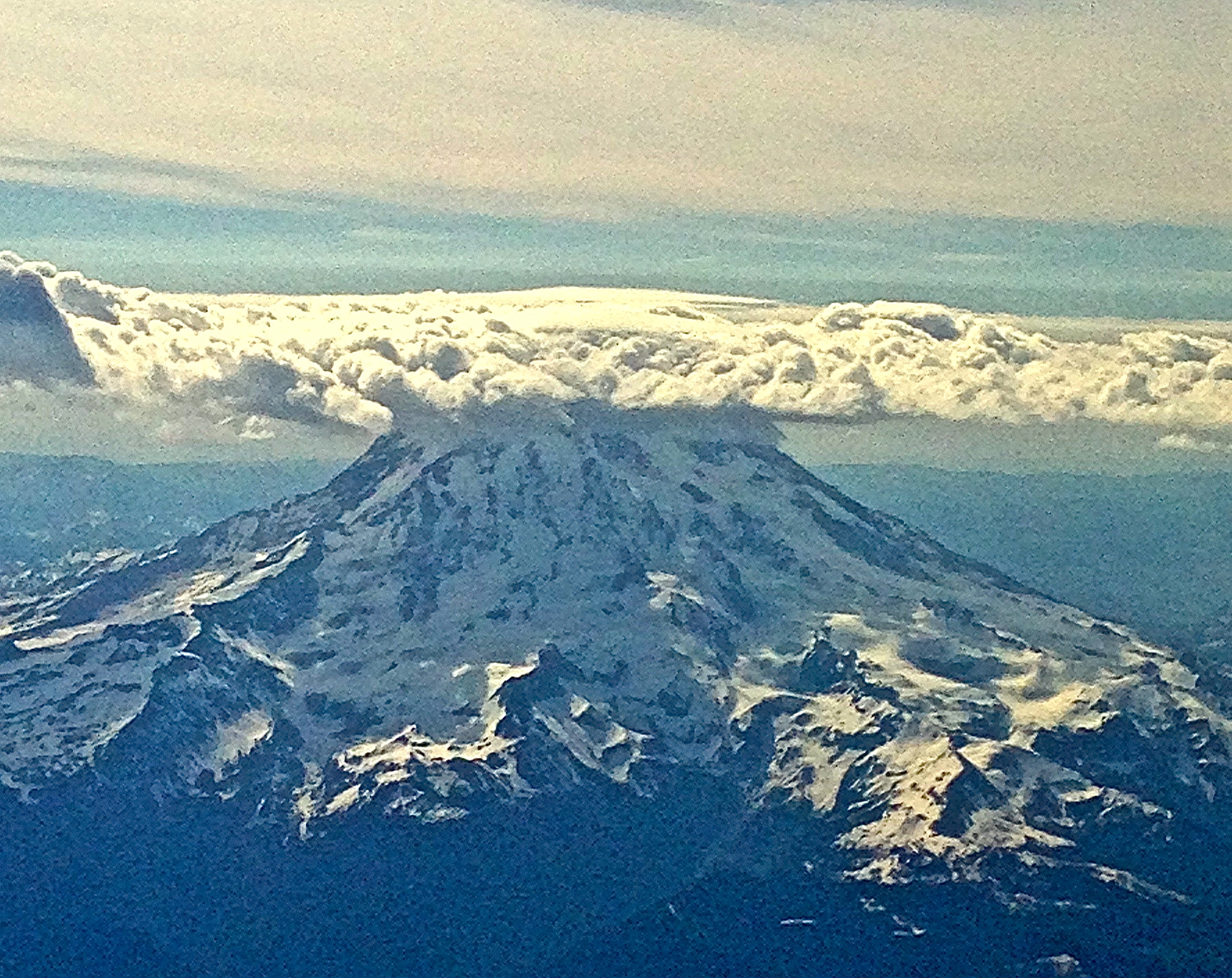
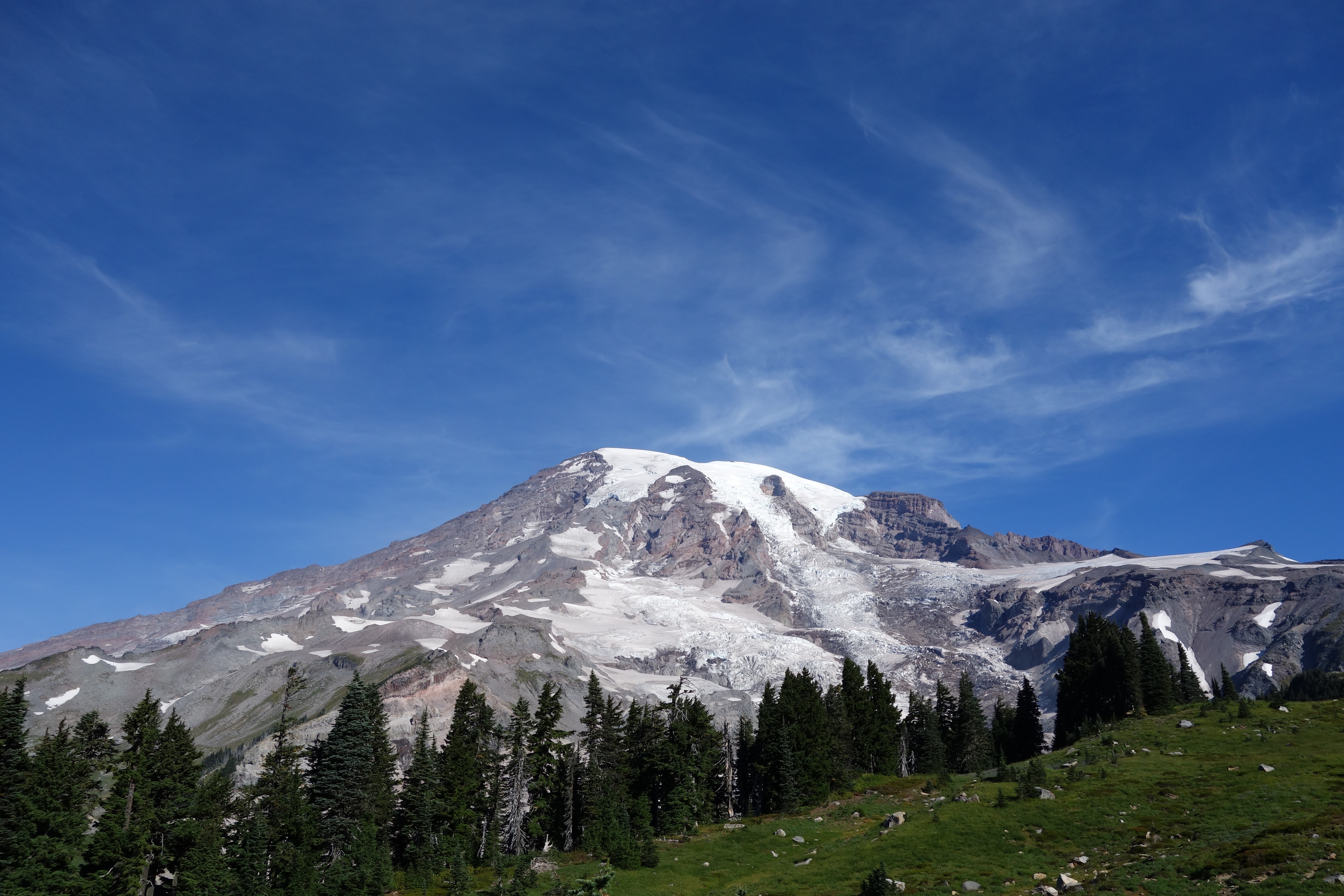
Mt. Rainier, the great white mountain (for me, the great white whale!). This photo was taken on Sept. 9, as I flew into Seattle to begin my journey to the summit. The photo is from the east/north, and you can see the summit crater on the top left flank of the mountain. The clouds are at about 6500 feet elevation.

Mt. Rainier is the most iconic mountain in the contiguous United States. Its nearly perfect conic shape rising 14,410 feet above sea level, and located only 35 miles from Tacoma and Puget Sound make it the most prominent geologic structure in the country; the white cap of the summit plays a game of hide-and-seek with the major metropolitan sprawl of Seattle-Tacoma and when the clouds rise even the most jaded Emerald City resident is jarred by its majesty. I have long wanted to climb Rainier, but never found the opportunity in my youth or the time in my middle age. However, my wife surprised me with a gift on our 25th anniversary in 2013 – the opportunity to climb the great white whale. Work commitments still made the scheduling of the climb non-trivial, but finally in September of 2014 I had the chance to join an organized expedition.

rainier

Mt Rainier from an airplane flight (SEA-DFW) I took in the summer of 2013. The clouds cover the summit, which has a topographic prominence of over 13,200 ft. There are 26 alpine glaciers on Rainier which gives it its perennial white appearance.

Rainier has a special place in the minds of geologists – it is a magnificant monument to the violence of plate tectonics. The Cascade Mountain Range stretches from Mt Garibaldi located just north of the Canadian-American border to the Lassen Peak in northern California. Along the 700 mile arc of the Cascade Mountains there are at least 20 young volcanic peaks – Rainier is the highest today, although the nature of stratovolcanoes is that Rainier will eventually follow the example of Mt. St. Helens and “blow its top”. In the 1960s it was recognized that the Cascades where the volcanic signature of a subduction zone – the collision between the Juan de Fuca oceanic plate to the west and the North American continental plate to the east. I was a graduate student at Caltech in the late 1970s, and understanding the nature of subduction was a subject of intense research. In addition to stratovolcanoes, subduction zones are the source of most of the largest earthquakes observed on the planet. Understanding why some subduction zones had mega earthquakes – events with magnitudes that exceed 9.0 – while others only had earthquakes with a maximum magnitude of 8 or 7 was a mystery. In the Seismolab at Caltech there was a daily coffee in which the faculty and other graduate students discussed the most recent seismicity and new areas of research. It was in these “coffees” that a generation of seismologists were created – everyone was expected to contribute to the discussion and debate, and very foundations of modern seismology were laid. Hiroo Kanamori, perhaps the greatest observational seismologist in history, was pondering the “why some subduction zones have mega earthquakes” question and working with  several of my peers developed the rationale for mega thrusts based on the concept of “coupling” between the subducting plates. This spawned the concept of “comparative subductology” which is rooted in Scottish geologist James Hutton’s concept of uniformatarism – if it is happening now, then it happened in the past, and will happen in the future. One of the surprises of the comparisons of subduction zones world-wide was that Cascadia looked a lot like the segments of the Chilean and Aleutian subduction zones that generated mega earthquakes in 1960 and 1964. However, Cascadian was pretty quiet seismically, so there was a general skepticism in the geologic community that Seattle would some day have an earthquake that would dwarf anything that could happen in California. Today the discussion is not about size of a future earthquake in Cascadia, but rather when and how often.

faulttrip

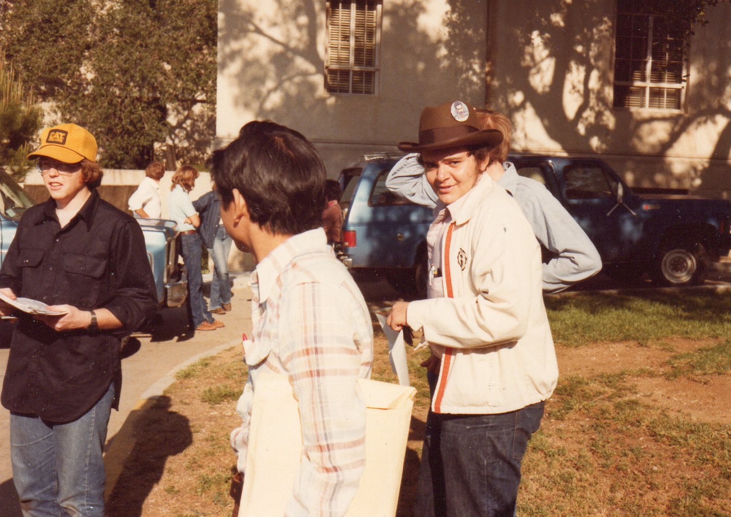
Caltech 1980 — I am one of the leaders of a field trip to Owens Valley (I am the guy at the far left with the clip board and the really strange ball cap) after the Mammoth Lakes earthquake sequence. The earthquakes occurred within a week of the eruption of Mt. St. Helens, leading many to suggest a link. The Seismolab was home to an amazing cadre of faculty and graduate students in the 70s and 80s that help define the paradigm of modern plate tectonics — including the understanding of the Cascadia subduction zone.

My own research at Caltech was more focused on computational methods for seismology and understanding the seismograms from nuclear explosions – however,  I was captivated by the discussions of mega-thrusts. In May 1980 Mt St. Helens erupted – and the reality of the restlessness of Cascadia hit home. I very much wanted to climb Mt. Rainier right then. However, it took nearly 35 years before the opportunity would arise. Of course, this is a geologic blink (or wink!) of an eye, and the decades had not diminished my enthusiasm to walk on the volcano.

overhead.rainier

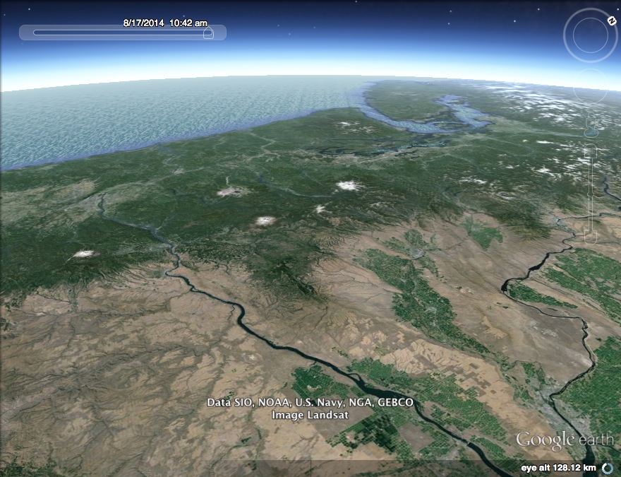
Google Earth image of the Cascades. The white dot in the middle is Mt. Rainier. To the south (to the left in the image) are Mt. Adams and Mt. Hood. This line of high peaks are stratovolcanoes above the subducting Juan de Fuca oceanic plate. The high mountains of the Cascades blocks the oceanic moisture and makes the Pacific Northwest coastal region a rain forest — and a relatively dry desert in eastern Washington and Oregon.

A brief history of Mt. Rainier (apologies to Stephan Hawking)

Most discussions that start with the topic of “history of Mt. Rainier” focus on it relatively modest relationship between the mountain and man. The earliest evidence of human occupation of the Pacific Northwest is about 13,000 years before the present, and it is certain that the mystic vision of the rugged, glacier -covered tower of andesite evoked the same since of wonder that it does today.

The first written records associated with Mt. Rainier are from the annals of Captain George Vancouver who was the commander of the English vessel Discovery that was sent to explore the Pacific Northwest. In May of 1792 the Discovery sailed into Puget Sound, and Vancouver saw the snow covered volcanoes of the Cascades, and noted three (Mt. Baker, Hood and Rainier) stood out “Like giants stand To sentinel enchanted land”. On May 8, Vancouver wrote “the round snowy mountain, now forming its southern extremity, and which, after my friend Rear Admiral Rainier, I distinguished by the name of Mount Rainier”.

Cascade_Eruption_2008v

The eruptive history of the Cascade volcanoes (figure from the Pacific Northwest Seismic Network) over the last 4000 years. Mt. Rainier is the largest of volcanoes, but it the last few thousand years it has been less active than Mt. St. Helens.

The eruption history of the Cascades – about 50 eruptions in the last millennium – doubtlessly meant that the indigenous peoples knew that the Cascade peaks were volcanoes. However, this first recorded suggestion that Rainier was volcanic was noted in the diary of William Fraser Tolmie in 1833. Tolmie was a remarkable naturalist from Scotland that was trained as a physician at Glasgow University, and joined the Hudson’s Bay Company in 1832. Upon arrive in Puget Sound one of the first tasks he undertook was to visit Rainier on a “botanizing excursion”. In is notes he wrote that the rocks of Rainier were “volcanic”. I don’t know what character of the rocks lead him to that conclusion, but Tolmie set the stage for USGS studies 40 years later that would confirm that Rainier was a composite volcano. As a side note, Dr. Tolmie as also the first person to write about an earthquake in Cascadia when a small tremor struck Puget Sound on June 29, 1833.

Mt. Rainier attracted many attempts to scale its heights, but the first documented successful ascent occurred by the son of the first governor of the Washington Territory and a pioneering mountaineer in 1870. General Hazard Stevens (a well-named military man, especially climbing Mt. Rainier) first came to the Puget Sound area with his father in 1854 and resolved to climb the “great white mountain”. After a military career and the end of the Civil War, Stevens returned to Washington Territory, and teamed with Philemon Beecher Van Trump in August 1870 to climb Rainier. Stevens wrote an account of their journey – which was quite harrowing – that was published in Atlantic Monthly in 1876. Stevens wrote “We had spent eleven hours of unremitted toil in making the ascent, and, thoroughly fatigued, and chilled by the cold, bitter gale, we saw ourselves obliged to pass the night on the summit without shelter or food, except our meagre lunch. It would have been impossible to descend the mountain before nightfall, and sure destruction to attempt it in darkness… Climbing over a rocky ridge which crowns the summit, we found ourselves within a circular crater two hundred yards in diameter, filled with a solid bed of snow, and inclosed with a rim of rocks projecting above the snow all around. As we were crossing the crater on the snow, Van Trump detected the odor of sulphur, and the next instant numerous jets of steam and smoke were observed issuing from the crevices of the rocks which formed the rim on the northern side. Never was a discovery more welcome!” Today we recognize that they had found fumarole activity, a reminder that silhouette of Rainier is only temporary.

muir.summit

The Muir party summiting Mt. Rainier in 1888.

P.B. Van Trump would visit the summit 5 more times including guiding John Muir in 1888.  Muir had to be convinced to undertake the climb, but once at the top he stated “I hardly know whether I had better try to describe the view but will say that for the first time I could see that the world was round, and I was up on a very high place. The air was very light…I stood there all alone, everything below and all so grand. I had never before had such a feeling of littleness as when I stood there and I would have stood there drinking in that grand sight, but they wanted to go so we started down”.

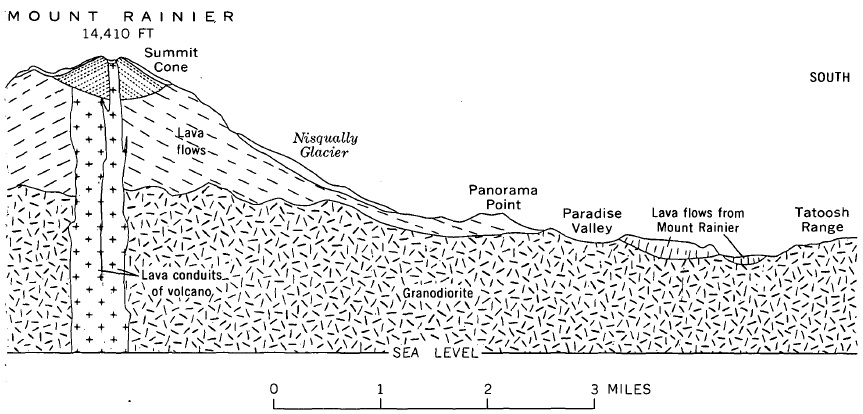
By the 1930s geologists had begun to unravel the complex volcanic history of Mt. Rainier. The present conically shaped mountain is quite young – less than 600,000 years old. Beneath the high reaches of the mountain though are a complex series of mostly volcanic rocks that record ancient geologic environment and long extinct versions of Mt. Rainier.  The most prominent basement rock is the granodiorite of the Tatoosh Pluton (there are a range of ages for the pluton which probably reflects a complex history – it cooled between 25 and 12 million years before present) which was the crustal magma chamber of former stratovolcanoes.

cross-section

A geologic cross-section through Mt. Rainier from Crandall (1969). The modern andesite and mudflows that define Rainier today lie above a large granodiorite batholith that is approximately 25 million years old.

Mt. Rainier birth as a stratovolcano probably occurred about 850,000 years before the present, and the bulk of the present conical shape is about a half of a million years old. The present summit has two craters that reflect recent eruptions.  It is clear that in the past the summit of Rainier was somewhat higher — maybe reaching 16,000 feet elevation — but explosive eruptions have removed the older cap rock.

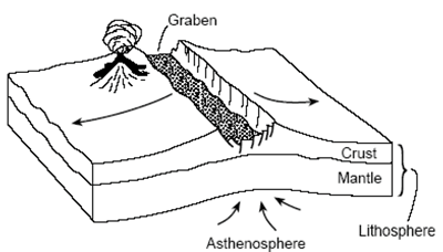
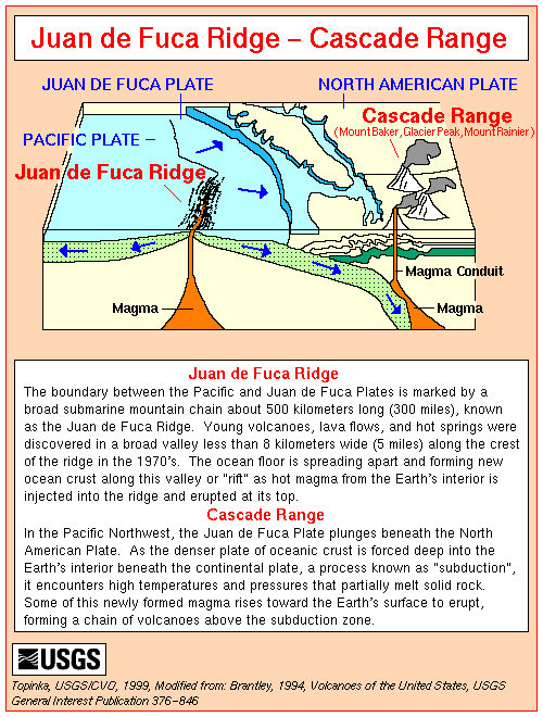
Although the nature of the Cascades and Mt Rainier were understood by the 1960s, it took the articulation of theory of plate tectonics to set the framework for why the stratovolcanoes exist. The North American plate, dominated by a large continental mass has interacted with an adjacent oceanic plate, known as the Farallon Plate, since Jurassic time (more than 150 million years before the present). Eventually most of the Farallon plate was subducted beneath North America, but a fragment remains off the coast of Washington, Oregon and northern most California. This fragment is known as the Juan de Fuca plate, and is being subducted at a rate of about 4 cm/yr.  In addition that subducted oceanic crust is young – about 10 million years old.  The USGS figure below shows a notional cross section beneath Washington.

subduction

The Cascade volcanoes are a direct product of the subduction of the oceanic crust of the Juan de Fuca Plate.  As the plate descends beneath North America the minerals within the plate release water due to increasing pressures and temperature in the mantle.  This water has the effect of promoting melting of mantle rocks in North American kneel above the sub ducting plate.  The melt rises, and eventually creates magma bodies in the lower crust, which in turn occasionally erupt in volcanoes at the surface.  Once a pathway for the magma to rise to the surface is established a stratovolcano grows. A science paper that was published this year (2014) provided an image of the mantle and crustal rocks beneath Mt. Rainier.

RainierElectricView

Electrical resistivity in the Earth for a cross section beneath Mt. Rainier (the location is shown with a triangle).

The electrical resistivity of rocks is highly dependent on a couple of things;  temperature, water content, and mineral content.  In the figure you can see the cold oceanic crust of the Juan de Fuca plate descending (the blue streak on the left side of the figure).  At about 50 km depth pressures are reached that cause a “de-watering” of the plate, which in turn, promotes the mantle melting.  This is the red and yellow colors beneath Mt. Rainier. The dark red blob to the left of Rainier is likely it’s magma chamber, located between 5 and 10 km below the surface.

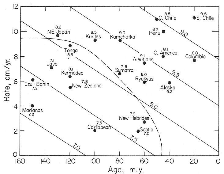
Although the volcanoes of Cascadia are not at all unexpected, seismologists did not understand why earthquakes seemed so infrequent in Washington.  Most subduction zones would have a much higher rate of seismicity that was observed here  — and this was the topic of discussion at Caltech in the late 1970s.  Kanamori and graduate student Larry Ruff looked at subduction zones worldwide and plotted the size of the maximum observed earthquake as a function of the age of subducting plate and the rate at which the subduction was taking place.  The analysis showed that rapid subduction of young oceanic plates resulted in very large earthquakes — mega thrusts.

kanamori.ruff

Size of maximum observed earthquake as a function of rate of subduction and age of plate being subducted (from Ruff and Kanamori, 1980).

Tom Heaton and Kanamori used this “comparative subductology” and other geophysical constraints to postulate that the Cascadia subduction zone was capable of generating a mega-thrust earthquake — as large as magnitude 9.0 (paper appeared in 1984). The paper was meet with a great deal of skepticism because the seismicity along the Oregon-Washington coast was quite moderate.  However, in 1987 Brian Atwater, a USGS geologist, found evidence of a major tsunami inland from the coast.  Finally, Japanese seismologists had long been perplexed by a tsunami that hit the coast of Japan in 1700 but did not appear to be connected to any Japanese earthquake.  Connecting the dots, seismologists were able to show that the 1700 Japanese tsunami was most likely created by an earthquake with a magnitude between 8 3/4 and 9 1/4 in Cascadia.

fig38

A trench through a coastal deposit in Oregon shows the sands brought ashore by the 1700 tsunami (Atwater et al., 1999).

Today there remains debate about the repeat frequency and size  expected for the Cascadia earthquake, but it is now excepted that it is only a matter of time before it strikes.  Mt Rainier seems like an ancient and noble giant benignly guarding Puget Sound. In fact, it is a very ephemeral geologic feature that will disappear in a few hundred thousand years, and most certainly will do violence to the equally temporary residents of the Pacific Northwest.  Surely this makes climbing Rainier most interesting for a geoscientist!

rainierfrombottom

Mt. Rainier from Paradise Ranger Station. This is the start of the IMG hike up the mountain – elevation of Paradise is at an elevation of 5200 ft, snow line is 7000 ft, and the top is 14,411 feet.

The expedition

The National Park Service keeps track of the number of people that attempt to climb Mt. Rainier and those that actually make the summit.  The numbers are a little surprising;  a little more than 10,000 attempt the ascent annually, and about half actually make it tothe top.  This statistic is pretty robust for the last 25 years, and clearly establishes Mt. Rainier as a signifiant challenge.  It is difficult to obtain quality data on the reasons that the success rate is so low, but the two most common anecdotes are weather and altitude maladies.  The weather is easy to understand – the strong oceanic flow from the Pacific brings significant moisture inland to the mountain. When the flow encounters the mountain it is forced to flow over the elevation – which cools the air, which in turn forcing out the moisture, building clouds, and raining/snowing. The jump off for my expedition is the Paradise Ranger Station (elevation 5,200 feet), which has an annual rainfall of 126 inches. That is twice as much precipitation that is received at Ashford (elevation 1,760 feet) the home to International Mountain Guides, my chosen expedition team. Ashford is only a few miles west of Paradise, but the difference in rainfall illustrates the rapid change in weather and how the steep topography of Rainier controls its environment.

The challenge of the weather, and the fact that a significant stretch of the ascent is on ice are the reason that I chose to join an expedition rather that trying to cajole a few friends (whom are all as old as I am) to take a week off work and avoid ice crevices.  I was not particularly worried about the physical part of the climb – running ultra trail races is more demanding – but I last climbed alpine glaciers more than 25 years ago, and as Shakespeare said “The better part of Valour, is Discretion”.  There are three well regarded companies that provide a suite of guided expeditions up Mt. Rainier.  I choose International Mountain Guides (IMG) for my adventure based on the rave review of a friend.  I was a little nervous about joining a group expedition – in general, I am not a group kind of guy – but my friend assumed me that this was a great experience, and in fact, he was correct!

On Wednesday afternoon (Sept. 10) the 8 climbers in my expedition checked in with IMG in the small town of Ashford which is situated on the Nisqually River.  The Nisqually is the main drainage of the southern half of Mt. Rainier, and I spent a couple of hours before checking in at IMG facility hiking along the river, and there are some spectacular exposures of the Paradise Lahar cut by the river channel.  The age of the Paradise Lahar is probably about 7,500 years before the present, and the thickness exposed near Ashford is at least 100 feet — it must have been a significant and destructive event.  The purpose of checkin is to assure that all the hikers are ready (so there is a very long equipment check), make introductions, and set expectations.  The climbers in my group come from all walks of life; the director of strategy for a unit from a major company, a nurse, commodity trader, dentist, venture capitalist, lawyer and a financial analysts for an aerospace company.  All have experience in mountains, although highly varied.  Most importantly, all seem like fine people to send the next three days with tied to ropes, sleeping in crowed tents, and cursing crampons.

journeybegings

IMG delivers the expedition to Paradise. The wind is very strong, and the posted wind chill is 38 degrees.

The expedition started on Thursday morning — loaded up out packs at IMG headquarters and traveled east up the Nisqually River to the Paradise Visitor Center.  I had weighed my pack early in the morning – full water bottles and mountaineering boots attached, and it was a marginally agreeable 46 pounds.  But, alas, I forgot I had to take a group food package that would eventually become my dinner and breakfast the next two days.  I don’t know how much my package weighed, but probably on the order of 5 pounds.  So, loaded pack was about 50 pounds, about 45 pounds more than I ever run with on the trail.  This was the only thing that I was truly dreading;  pre hip and knee replacement 50 pounds would be no problem, but not positive what the next 3 days would hold.

Although the morning felt cool at Ashford, it was down right cold at Paradise.  The wind was blowing strongly, and the posted wind chill was 38 F.  IMG assigns 1 guide for every 2 climbers, so our team was 12 strong.  Our lead guide was Cedric Gamble, and had the job of both assessing risk and assuring the team that were are super strong climbers; thus, we heard both the comment that the wind was amazing and not at all usual, and surely this weather will pass and all is good.  I had my Garmin GPS watch and tracked the multi day climb.  By my watch, the starting elevation was about 5100 feet. The path wanders out of Paradise and climbs up to Pebble Creek (this was about 3 miles by the route we were on, and a gain in elevation of 1900 feet).  Hiking is easy even with the full pack, although the wind gust literally blew me over a couple of times.

muirsnowfieldup2

Climbing the Muir Snow Field – putting on our mountaineering boots.  The views to the south are spectacular with Mount Adams, St. Helens and Hood dominating the horizon.

Crossing Pebble Creek, the trail runs into the Muir Snowfield.  The snowfield is not a glacier but a perennial mass of snow that is both slick and wet.  The path for our expedition is to follow the snowfield up to Camp Muir, some 2.2 miles and 3000 feet elevation gain away.  We changed out of our trail shoes into mountaineering boots for the trek up to Muir — this meant that my pack was lighter, but it also meant that I had to wear the plastic mountaineering boots, which are  composed of an outer hard plastic waterproof shell and an insulating inner boot. These are heavy and warm, and I absolutely hate them.  Too heavy and hot, it was like running in dress shoes.  Over the next couple of days I would realize that these boots, when outfitted with crampons, where by far the most difficult aspect of the entire expedition.

campmuirIMG

IMG tent at camp Muir – a great restaurant.

About half way up the Muir snowfield we ran into another IMG team descending the mountain.  A rather sobering and somber conversation took place between the two teams — the descending team had not been able to summit because of the high winds and had turned around at 13,000 ft elevation.  It was very difficult to imagine that one could not summit on a clear day and that there were many factors that determine a successful climb.  The rest  of the first day’s climb is easy into Camp Muir.  Muir is an assortment of small buildings situated on a ridge that separates the snowfield from the Cowlitz Glacier.  The buildings serve as a way station for climbers, and IMG has a small room there where the team can bunk down for the night.  The room is about 20 x 20 feet, and is a couple of plywood shelves to role out your sleeping bags.  Pretty small quarters, but shelter from the wind (it also turns out the expedition members don’t really snore nor have nocturnal gaseous emissions).  The IMG guides have a tent that serves both as the communal restaurant and their sleeping quarters.  Dinner at the IMG tent was a very pleasant surprise, and suddenly I felt very guilt for my mental grousing about carrying that five pounds of community food.  Dinner serves as a chance for all the team members to learn about each other — and I learned far more than I ever thought possible about pediatric dentistry, the incredible attributes associated with living in Coeur d’Arlene and climbing Aconcagua (I am jealous).

mapofrainier

A sketch of the east side of Rainier (from Crandell, 1969). The path for our ascent crosses the head of Cowlitz Glacier, then follows the rock spur below Gibraltar Rock up to cirque of Ingraham Glacier over looking Little Tahoma Peak. The original summit of Rainier went from Point Success to Liberty Cap – before a major eruption 5500 years ago, Rainier was 16,000 feet high.

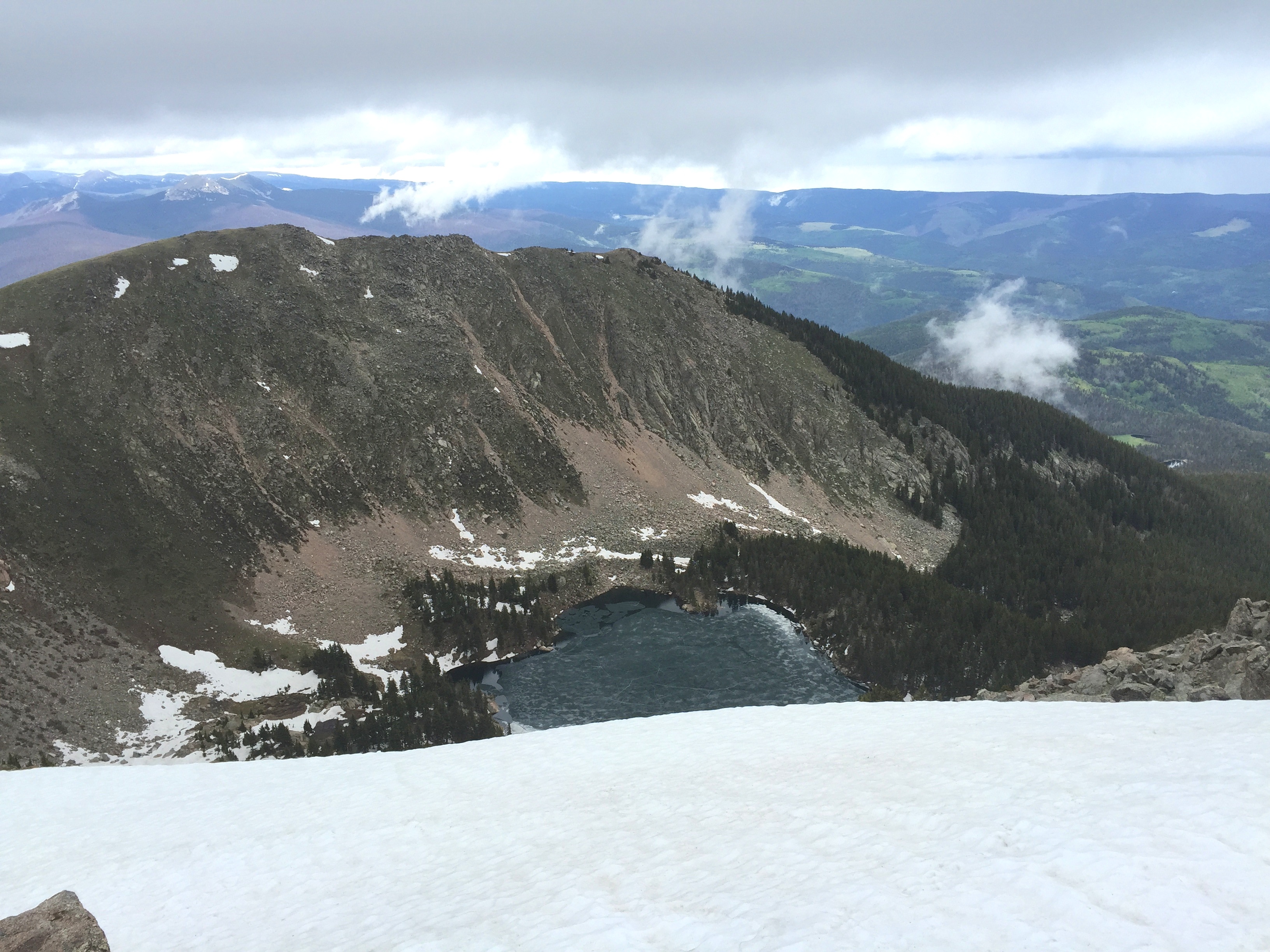
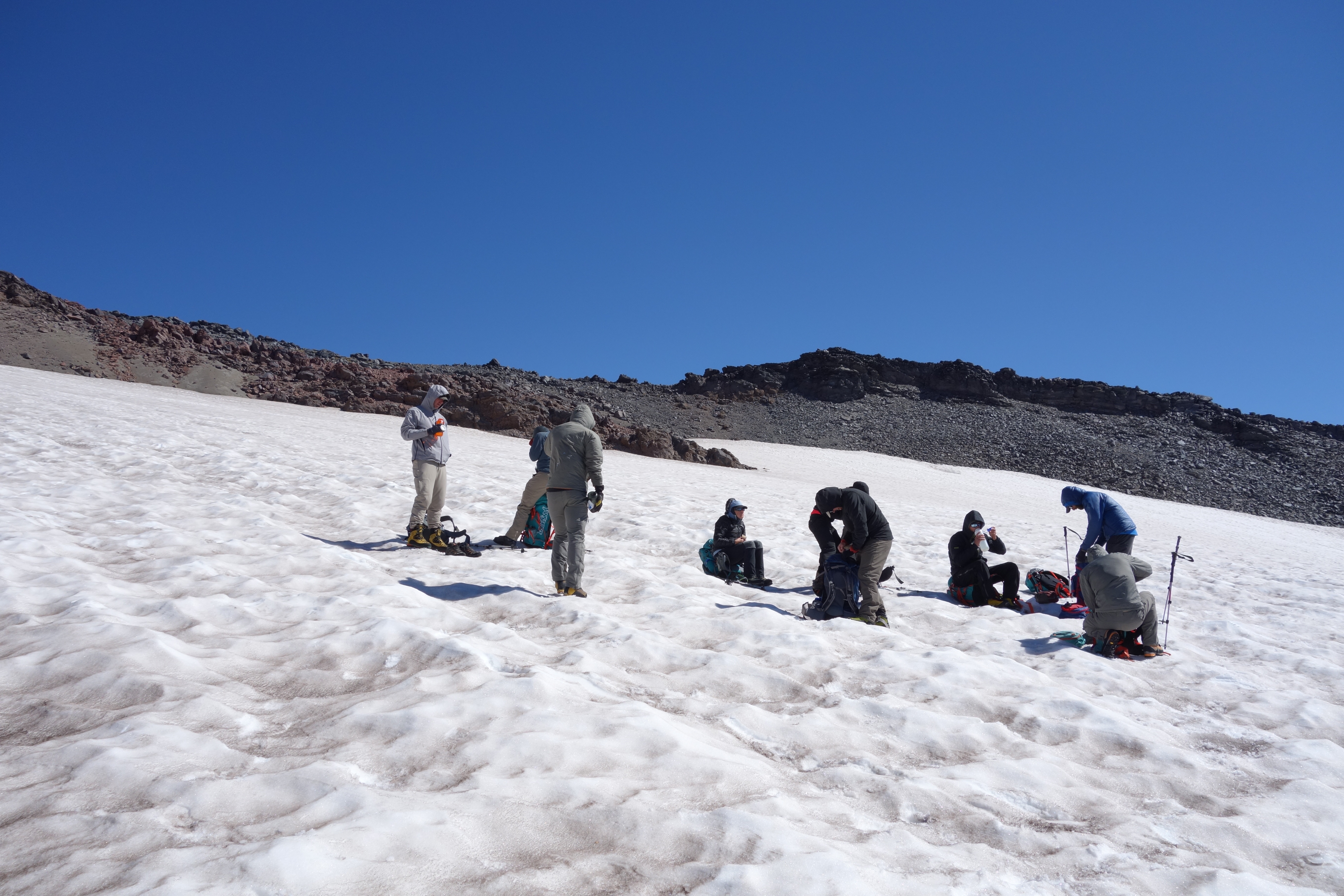
Friday morning the trek really begins — we practice ice axe skills, crampons on ice, and roping up groups of climbers.  We cross over Cowlitz Glacier and then have a short hike up what is called Cathedral Gap;  the Gap section is bare rock and our passage is in our crampons, a first distasteful snippet of walking on rock and dirt while wearing sharp spikes of metal.  After a relatively short hike we arrive at the high camp located on the upper reaches of Ingraham Glacier.  Ingraham Flats is a moderately sloping section of ice at an elevation of 11,500 ft.  The camp is four tents for the climbers, two more tents for the guides, and small kitchen carved in the ice and snow.  The views are breath taking; the sounds are unnerving.  The Flats are framed by Gibraltar Rock to the south and the Disappoint Cleaver to the north.  Gibraltar lords over the camp as vertical cliff of nearly 800 feet, composed of layers of eruptions and lahars past.  Every few hours rocks fall from the cliffs, a not so subtle reminder that Rainier is always changing.  I also peer up at the ice of the head of Ingraham Glacier and think about the disastrous ice fall in 1981 that took the lives of 11 climbers.  It is the worst climbing accident in American history, and to be in it’s shadow is a reminder that gravity is unforgiving.  I decide it is best not to ask about the accident with the other members of the team.

highcamp2

High Camp – Ingraham Flats, on Ingraham Glacier.  Over my left shoulder is the Cleaver, a nasty stretch of rock that is the heart of the climb to the summit (which is visible some 3000 feet above us in the center of the photo).

We have “dinner” at 3:45 on Friday so that we can be in the tents by 5:30 pm.  This is to facilitate a 1:00 am wake up call and a 2 am debarkation for the summit.  Sleep that night seems fine for me (better than most of my hotel visits to Washington DC every couple of weeks), but most of the team is beginning to feel the effects of altitude.  Living at 7400 feet elevation has its rewards!  Breakfast at 1:15 is instant oatmeal and coffee.  I opt for multiple cups of coffee and pass on the oatmeal.  At 11,500 the boiling point of water is about 185 degrees F instead of the sea level value of 212 degrees, so the coffee is tepid.  No matter, it is still nice fuel.  The morning is cool – my thermometer that I left just outside the tent reads 28 degrees F.  The wind is still though, so it is quite easy to dress comfortably.  Unfortunately, before we rope up to cross the glacier and head up the cleaver we remove layers to assure that we don’t over heat on the climb.  That means it is cold when we start our trek.  The climb is steep, and the half moon gives a nice glow, but mostly you look at the ground in front of you illuminated by your head lamp as travel.

highcamp

High Camp from Disappointment Cleaver. This picture was taken on the descent, mid-morning.  The tiny dots are our tents at the high camp.

The Cleaver is an 800′ elevation climb on rocks.  It is technically the most difficult part of the entire ascent.  Not particularly physically challenging, but the combination of large blocks of Andesite, crumbly scoria, and even some obsidian means that every step of the crampon encased boot is a challenge. Around 3:30 we finally finish with the Cleaver, and are back on the welcome crunch of ice.  The guides lead us back and forth up the south face of Rainier until we finally cross the lip of West Crater about 7 am.  The sun is just rising, and the winds are calm.  Unbelievably majestic.  Crossing the lip of the crater is considered a summit, but I know that we are across the crater from the true high point on Rainier.  Several of us drop our packs and hike the couple of hundred yards to the northwestern rim and climb up to the Columbia Crest, the “true” summit of Rainier.  We arrive there about 7:30, and revel in the success of the trek.

summitteam

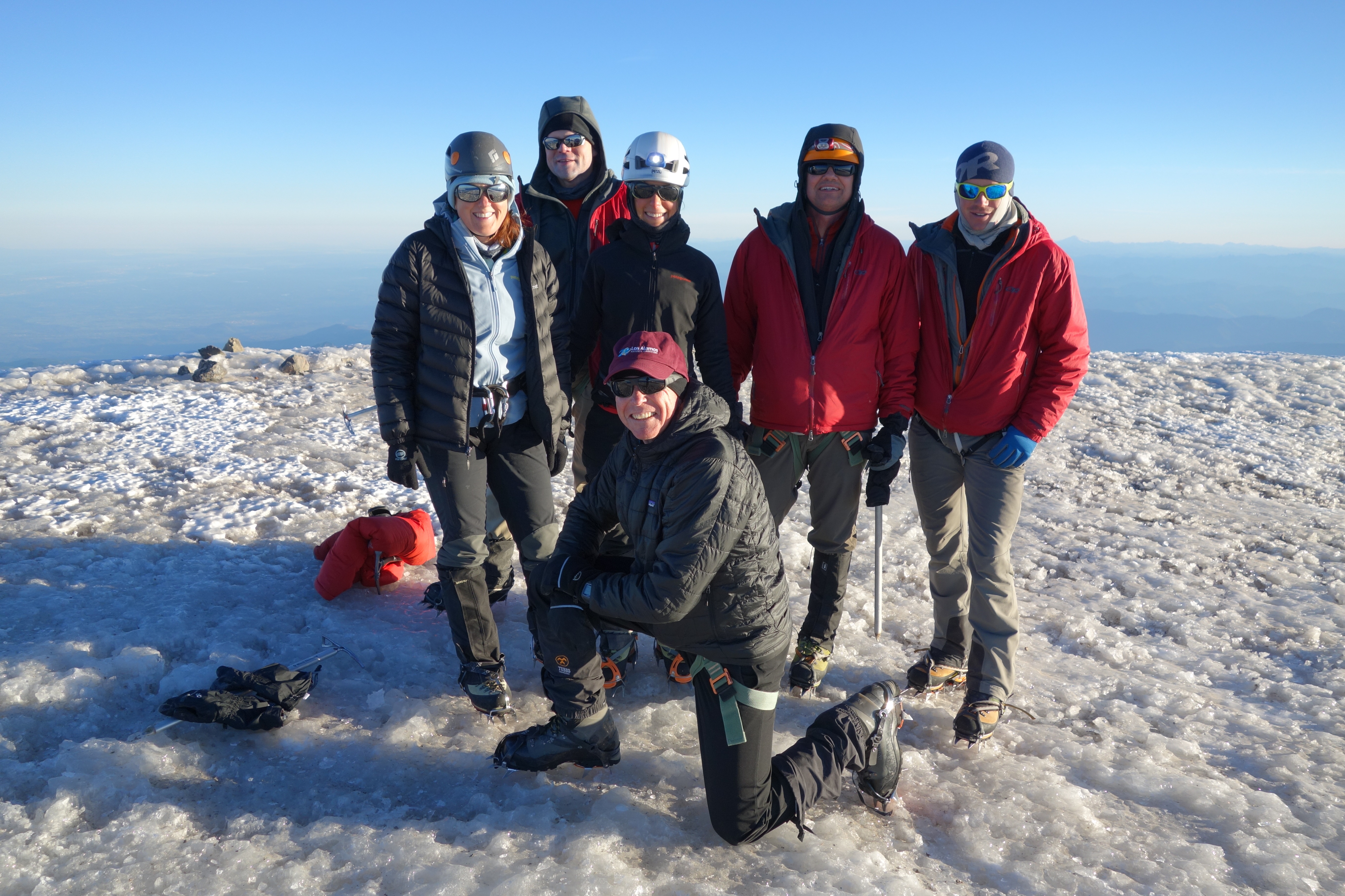
Summit Team at Columbia Ridge. Just below me is the USGS marker for the elevation.  The marker was placed in 1956 – my birth year.

The views from the summit are both spectacular and disappointing. The skies are clear, and one can easily pick out every major volcano in the Cascades well into Oregon. However, the humidity in the air gives a sense of haze in the distance that one never sees from the summit of a 14er in Colorado. The crater itself is magnificent. A stone circle created by an eruption a few thousand years ago, it has dozens of fumaroles all along the rim. Wisps of steam give hint to the hot rock not far below the surface. I applied the sniff test to several of the fumaroles, and only caught the faintest notion of sulfur; mostly was just moist stream.

rainiercrater

West Crater

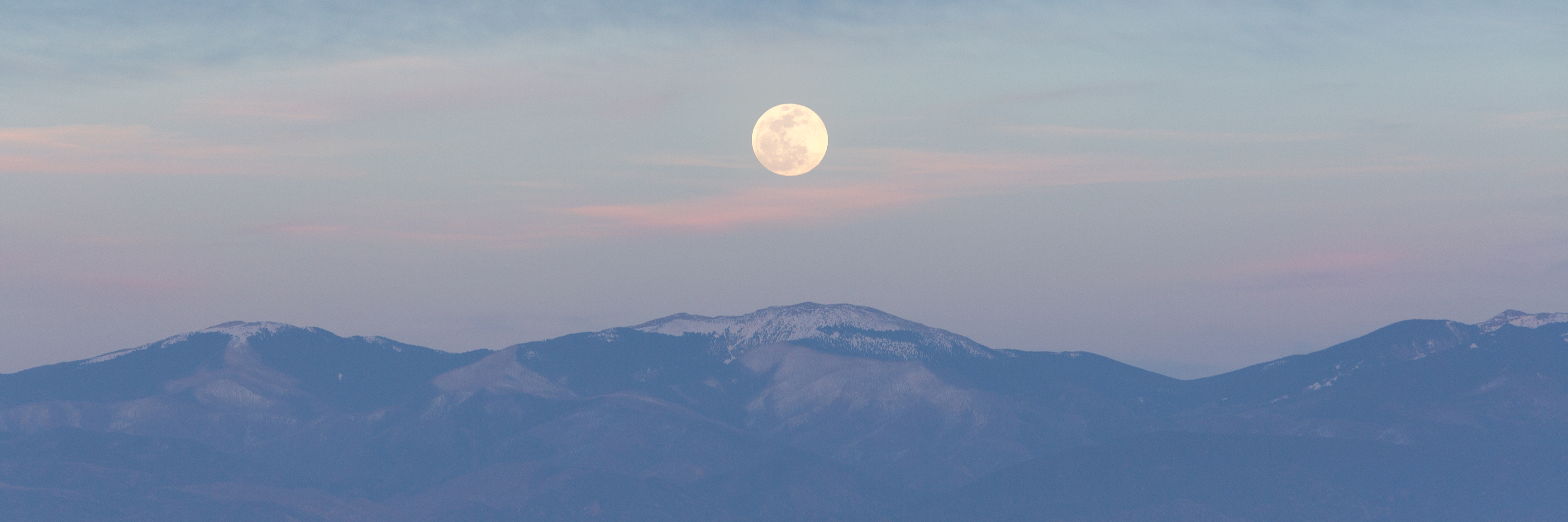
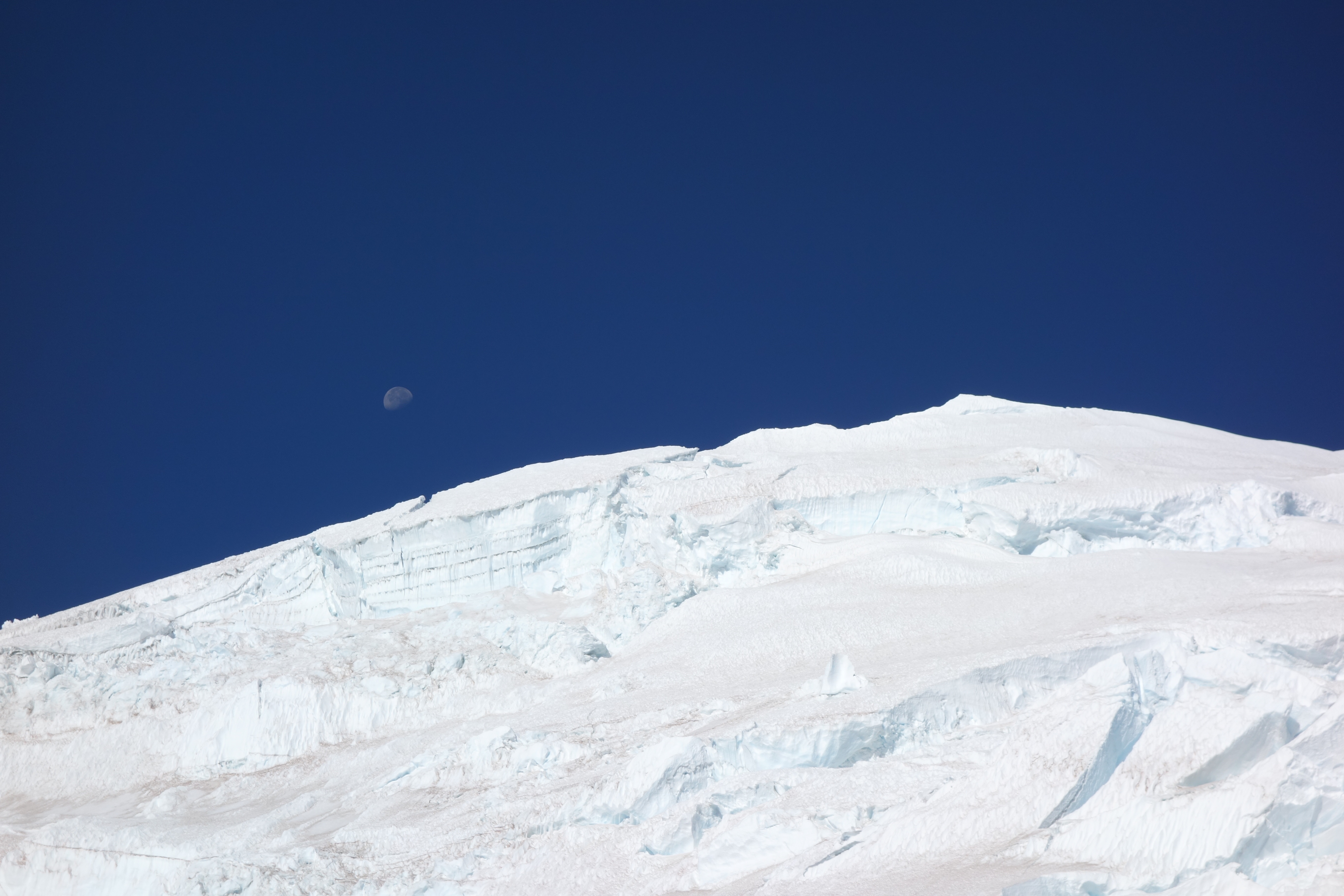
Around 8 am we began our long trip reversing our footsteps back to Paradise. By my Garmin we had hiked 12.2 miles and with the ups and downs (mostly ups!) we had gained 9600 feet elevation. The journey down was more difficult than I expected – not because it was a physical challenge, but because the sun was shining and the views were extraordinary! I wanted to stare and ponder the magic landscape, which meant I did not want to focus on traveling on a rope along an icy and steep trail. The descent back to the top of the Cleaver went by uneventfully, and I was able to get a picture of the moon setting over the top Mt. Rainier.

moonsetting

Rainier Descent – moon setting over the rim of the crater.

The traverse down the Cleaver was by far the most difficult part of trip down. We are all a little tired, and those damn boots and crampons! I did manage to stab myself in the left leg with the crampons from my right boot. I drew blood, and it is only appropriate as a sacrifice to a great mountain. We finally get back to high camp for a brief rest, and some lunch. The journey back to Camp Muir was pretty trivial, and we stop for some water at the IMG tent. All that stands before us and the end of the trek is the Muir snowfield – how hard can that be? However, we decide to keep on the crampons to cross the field since it is soft and slick. Drudgery! But unexpectedly, the slog was made tolerable by the fact that it was Saturday, and there was a menagerie of folks climbing the snowfield from Paradise. We saw people in shorts, skirts, tennis shoes, formal wear, and of course, flip flops! Consider that these snowfield adventurers had invested hiking more than 3 miles and 2000 feet elevation gain, you have to wonder how much thought went into their apparel. One of the most humorous moments of the entire journey was when one of our teammates engaged a woman in a long dress in conversation on the snow and said “you can do it!”. He was being positive, but also preposterous! Finally, at Pebble Creek we shed our boots and crampons, and all is right with the universe.

The trek up Rainier was a spectacular experience. I am fortunate to have combined the wonder of a high mountain climb with a favorable group of colleagues, and wonderful guides. I could not have been more delighted – but of course, I got something a little extra. On the flight home Sunday morning the American Airlines flight to Dallas took off to the south out of SEATAC and flew towards Rainier. Once we reached the Nisqually River the pilot took a hard left and flew right over Paradise, and suddenly out my window was the entire picture of my trek. Fabulous!

fortheblog

Passing over Rainier on the way home (9/14/14). The image is high resolution so click on it and expand. The various way stations are labeled.

Rainier will one day erupt, and will no longer be the high point of the Cascades. I am grateful that I got to experience the great mountain in its finest state – and mood.

Climbing the Grand Staircase: An ultra trail run in the footsteps of Clarence Dutton

May your trails be crooked, winding, lonesome, dangerous, leading to the most amazing view.  Edward Abbey, in the Preface for Desert Solitaire

hoodoos1

Hoodoos of Bryce Canyon, just a few miles east of the trail route for the Bryce 100. The hoodoos are erosional columns in the Claron Formation, a 30-60 million year old lake limestone.

Los Alamos, New Mexico – my hometown – sits on the eastern edge of the Colorado Plateau, an expanse of high desert and pastel hued rocks that covers more than 125,000 sq miles.  The plateau is a geologic marvel; the entire geologic history of the Western United States is laid bare from the bottom of the Grand Canyon where 2 billion year old Vishnu Schist is exposed to the Pink Cliffs of Bryce Canyon in Utah which are 35 million year old sediments that were deposited in a great inland lake. The nearly 2 billion years of history is stacked like a layered cake gently tilted on its side, barely disturbed by faults and folds and other signs of geologic trauma.  There is a huge gap in time – more than a billion years – between the Vishnu Schist and Tapeats Sandstone overlying it, which represents a long epoch in which the region must have stood far above sea level.  Located above the 540 million year old Tapeats Sandstone there are younger rocks, which geologists can use as  a yardstick of ocean invasion and retreat.  Thousands of feet of sedimentary rock record the slow grinding of the ancient continents into gravel and dust.  Nowhere else on Earth is the last half of a billion years of history so beautifully preserved.  The western United States has suffered continental collisions, incredible crustal stretching, massive volcanic eruptions, and yet the Colorado Plateau escaped any significant deformation.  The layered cake geology of the Colorado Plateau is clear road map to our geologic past!

I was looking for a 50 km trail run in southern Utah when I found the Bryce 100 (which has 3 different distances to run, including 50 km) – and it looked like a wonderful tour through a high part of the Colorado Plateau.  I signed up with enthusiasm, and then realized that it was in the middle of June.  I looked at the historical meteorological data at a weather station in Bryce Canyon and realized it likely to be as warm as 85 degrees on the day of the trail run.  Trail runs in the heat are very much like the old saw of the frog in a pot that is brought to a slow boil (lethal, but one in which the frog is a willing participant).  However, the idea of running in the footsteps of John Wesley Powell and Clarence Dutton, giants in American Geology, was enough to blind me to the dangers of hyperthermia and hypohydration.

finalwave

Paria Canyon is just south of Hiway 89 traveling between Page, Arizona and Kanab, Utah. Around Paria Canyon are a number of incised channels cut through the red colored Navajo Sandstone. This sandstone was deposited on land – and the fabric in the rock was formed as crossbedding is wind blown dunes. This particular wash is one of the most famous “picture” sites that no one knows how to get to on the Colorado Plateau. The erosion across the fabric gives the appearance of waves, and this is called “The Wave”. I visited this wonderful place on my journey to the start line of the Bryce 100.

For me, a trail run is more about adventure than about being in a “race”.  Seeing new places from a vantage point I have not had before, challenges, and thinking about nature are the joy of the trail.  Although I live on the edge of the Colorado Plateau, I have spent far less time in the high desert than in the rougher mountains of Colorado and New Mexico. But I have an affinity for the Colorado Plateau also – the modern portrait of the geology of North America was laid out here by Powell and Dutton, who were inspired by the carved rock towers of Monument Valley and the vastness of the Grand Canyon.  The Bryce 100 was a trail run and a field trip!

Geologic Giants

The 19th Century was the most remarkable period of scientific discovery in history. In fact, the “profession” of science and the term scientist was first coined in 1833. This was a time of intellectual enlightenment, and the concept that laws governed every aspect of nature and life changed  human thought. Gauss, Laplace, Legrande, and Fourier invented modern mathematics; Dmitri Mendeleev invented the periodic table of elements; Lord Kelvin (Scotsman William Thomson) invented the temperature scale and formulated the second law of thermodynamics; Charles Lyell published Principles of Geology in 1830 and established the concept of uniformitarianism; Charles Darwin published The Origin of Species and established the theory of evolution.

Clarence Dutton

Clarence Dutton – geophysical poet, and namer of of the attractions and vistas in the Grand Canyon

Against the heady backdrop of new theories for life and forces governing nature, the empty “space” beyond the 100th meridian drew the interest of the nation.  As the civil war ended, there was pressure to civilize and cultivate the west, but little was actually known about the region.  The U.S. government decided to fund four major mapping expeditions to western half of the country — these were lead by Clarence King, George Montague Wheeler, Ferdinand Hayden, and John Wesley Powell. All these men left their signature on geology, but it was Powell that was truly a visionary.  Powell lead the first successful traverse down the length of the Colorado River through the Grand Canyon in 1869, and his follow-on visits to the region lead to the first modern understanding of great arid regions of the southwest.  Powell eventually convinced a  colleague to map the Colorado Plateau in detail – that colleague was Clarence Dutton.  Dutton’s accomplishments are extraordinary, but his prodigious legacy is often overlooked.

Image

Cover page of Dutton’s classic work on the geology of the “missing” portion of the geologic map of the USA

Clarence Dutton is a hero of mine. He had remarkable insight into “how the Earth works”, and published works on geology, volcanology, and the geology of earthquakes. In 1889 he coined the phrase “isostasy” and proposed why mountains are high and valleys have low elevation. Along with this keen scientific insight came the soul of a poet. Dutton’s words paint vivid images, and he is compared to John Muir in capturing the heartbeat of a landscape. Dutton wrote the classic paper in 1880, and it remains a masterpiece.

grandstaircase

The Grand Staircase – climbing out of the Grand Canyon. The 500 million years of geologic history in the rocks preserves the entire evolutionary record of life on Earth. Figure from the Utah Geologic Survey (click on figure to enlarge).

When Dutton was doing the fieldwork for the Geology of the High Plateaus of Utah, he noted that the layered cake geology of the region created a series of steep cliffs and flat terraces that looked like a “great stairway” climbing north from the Grand Canyon. This description eventually morphed into the “Grand Staircase”, the name the region is known as now. The geologic cross section above shows the series of cliffs – there are 6 prominent cliffs as you travel the 150 miles north from the bottom of the Grand Canyon. The final stair is the Pink Cliffs which is topped by the Paunsaugunt Plateau. The Bryce 100 is run on and around the Paunsaugunt Plateau – and the top of Dutton’s Grand Staircase!

Image

A small section fromDutton’s map “Geological map of the district of the high plateaus of Utah” centered on the area of the Bryce 100.

In Dutton’s 1880 work he published wonderful color maps to illustrate the geology.  The map above is a section from Dutton that is centered on Paunsaugunt Plateau and the trail for the Bryce 100.  The course travels along the western edge of the plateau, then climbs up and over the plateau to finally descends to the finish along the drainage of the East Fork Sevier River. The yellow color on the map represents the Claron Formation, which geologically is a series of lake and river deposits – sands, gravels, and cobbles along with a few limestones. The lake environment was rich in iron, and the pink color of many of the rocks is due to iron oxide staining. The rocks of the Claron are easily eroded, and the climate of the high plateau means that frost wedging plays a roll in breaking apart the strata. It is this frost wedging that produces the famous hoodoos (or rock towers) that populate the Bryce region.

Dutton wrote of the very region that the trail run traverses – the course is truly in the foot steps of a geologic giant.  One last comment on Dutton (and another reason he is one of my heroes). He was an early hire into the brand new US Geologic Survey in 1875. After his outstanding work on the Colorado Plateau he worked on earthquakes and volcanoes and was promoted to the chief of the volocanology unit at the USGS.  He eventually became disillusioned with the growing agency and wrote: “Our Survey is now at its zenith & I prophesy its decline. The ‘organization’ is rapidly ‘ per fecting’, i.e., more clerks, more rules, more red tape, less freedom of movement, less discretion on the part of the geologists & less outturn of scientific product. This is inevitable. It is the law of nature & can no more be stopped than the growth & decadence of the human body.” Not only do I get to share the Pink Cliffs with Dutton, but also his views on the crush of bureaucracy.

moonsetting

The full moon setting over the start of the race. The course heads for the moon, and then wanders around the Paunsaugunt Plateau

The Race

The Bryce 100 — which is actually a 100 and 50 miler along with a 50k — is staged out of Bryce Canyon City. “City” is a misnomer – the town sites at the edge of the national park entrance, and is a collection of hotels and various adventure companies.  I chose to stay at the main hotel, Ruby’s Inn, a sprawling complex of buildings typical of concessionaire hotels in western US parks.  My room is in a remote building, and everyone in the building seems to be here for the race.  As I make my way to my room I pass countless rooms with their doors open – and there are stacks of water bottles, jugs of protein powder, and all sorts of stuff that ultra runners accumulate.  There is a major benefit to having a hotel dedicated to the runners; lights are out at 9:30 pm, and there is nary a sound until 4:30 in the morning!

stuff

The secret to the ultra – stuff. My stuff includes Tailwind formula for my water bottles, stinger gels, Kind candy bars, lots of sun screen, and gloves for the first couple of miles

The runners are bused to the start of the race, about 7 miles from the hotel.  The starting temperature is a brisk 39 degrees, but perfect conditions for running. There are about 135 runners in the 50 km race, mostly 20s and 30s somethings, and most are in running groups.  I am the only person from New Mexico, but as with most trail runs, everyone is very friendly and chatty.  I find 3 different geologists running the race!  Clearly, the attraction to interesting geology is a big deal for this race.  The course takes off to the west and climbs from 7600 feet elevation to about 8300 feet elevation over the first 6 miles.  The first six miles is a roller coaster – run up 50-200 feet and then descend the same distance as the course crosses dozens of small drainages.

BryceCanyonRun

The Bryce Canyon Route for the 50 km — actually 32.6 km, and 5400 feet elevation gain. The course travels to west side of P Plateau, and climbs up and over into a drainage

The first two miles are on a forest service road – not too interesting for running.  However, after two miles the course follows a wonderful single track.  The track is very smooth, a consequence of the erosion of the base rock – the Claron Formation.  The Claron is about 200 m thick on the Paunsaugunt Plateau, and is composed of soft, red colored siltstones and white colored limestones that are rich in sands. These sedimentary rocks were deposited in an ancient lake that was formed due to the rise of the Rocky Mountains some 70 million years before the present. The rise resulted in a basin to the west of Rockies, and Lake Claron filled this basin – at is maximum size it was similar in area to Lake Michigan. The rocks are rich in iron and manganese oxides, which give the distinctive color. Around 30 million years before the present the Colorado Plateau began a period of uplift, and Claron Lake disappeared, and the former lake bottom rocks became exposed and formed the Pink Cliffs.

runninghoodoos

Running among the HooDoos in the Claron Formation

Between miles 6 and 7 the trail wanders among some wonderful hoodoos.  In fact, the rocks are so interesting I am having trouble not stopping a shaping photos every couple of hundred yards!  The hoodoos form because the Clarion is relatively soft, but has thin strata that are more resistant to erosion.  Frost wedging plays a fairly unique roll in the hoodoo formation – cracks are filled with moisture, and when it freezes it parts the harder, more resistant limestones leaving small “caps” that eventually sit atop columns and chimneys.

na_hoodooformation

Graphical explanation for the formation of Hoodoos along the Pink Cliffs. The rocks of the Claron Formation are quite soft and easily eroded – but what is unique here is the roll of frost wedging breaking apart the rock. The frequent freezing in the region causes soil moisture to freeze and expand which “pries” apart blocks of rock. Repeating this process isolates pillars, or the Hoodoos (Figure from National Park Travel)

The first 10 miles are pretty fast.  I roll into the first aid station at exactly 2 hours (the station is 10.4 miles from the start).  I feel fantastic, although it is getting warm – at least to me.  It is 8 miles to the next aid station, and I have a plan to be there a little before the 4 hour mark.  All my life I have loved maps.  I am an expert at reading maps – but I fail miserably on this next section of the course.  I used the course map posted on the website for the race, which shows the elevation at a very corse scale.  I estimated that there would be modest climbing and descending over the 8 miles, but in fact this section of the trail is quite difficult.  There is much more climbing and very slippery descending than I expect.  The first thing I did when I got back to the hotel room was to download the USGS quadrangle for the region – WHAT!  At the higher resolution it is obvious that this section is tough.  I am embarrassed that I let scale screw me…

After the second aid station the climbing really begins.  It is a lot more walking than running for me.  I actually pass lots of people on the ascent of the Paunsaugunt Plateau.  But the course becomes truly diabolical at mile 23.  The elevation has dropped to 7700 feet, and over the next 2 miles the dusty and sandy trail climbs 1400 feet.  Although most of the course up to this point has had liberal tree cover, the Pink Cliffs show no mercy or vegetation. I swear it is 100 degrees, but alas, when I check the weather record at the Bryce Canyon airport station, I find it was actually 65 degrees.

onthewayhome

Looking north on the long climb up the Paunsaugunt Plateau. The Pink Cliffs are beautiful, and steep.

The views are breath taking, but I am toast at the final aid station, mile 25.  I refill both my water bottles with Gator aid, but it is a bit too late.  The trail after the aid station joins a hard packed BLM road.  It is not particularly pleasant running, but the home stretch is afoot.  The first couple of miles of the road actually continue the climb, and finally at mile 26.5 top out at 9200 feet elevation (by my watch).  Then it is downhill!  However, I just kind of amble down the road, and all those folks that passed going up the hill scream past me.  I got road rash from several that passed me at a high rate of speed!  I do meet several interesting people on the descent, and have conversations;  I meet a young man from Monument Valley that has never run further than 13.1 miles before today.  He is celebrating 6 months of sobriety, and was recently baptized – a joy to talk to.  I meet a couple of people from Phoenix that have only been trail running for the last year.  They are very fast until mile 29, and then absolutely die.  The final part of the course is another uphill for a mile, and it is really tough.

It took me just under 8 and a half hours to finish the 32.6 miles (I love that trail runs are ALWAYS longer than the standard amount).  Waiting for the bus back the Bryce Canyon City I talk to the other runners – as always, at the end, everyone is happy.  The relief of finishing, and the any pain fades pretty fast.  My joy was getting to wander through some unique and interesting geology.  I think I will do this again.

towerbridge

Tower Bridge, Bryce Canyon.

Running along the beach – A 300 million year old beach: the Cedro Peak 45 km trail run

Geology is the study of pressure and time. That’s all it takes really, pressure, and time. Comments by Red in The Shawshank Redemption (1994).

Image

A Google Earth view looking north along the crest of the Manzano and Sandia Mountains, just to the east of Albuquerque, New Mexico. The Sandia and Manzano mountains are a 75 km long north-south, and are the uplifted shoulder of the Rio Grande Rift. The Sandia and Manzano mountains are separated by the Tijeras Canyon which provides the passage for interstate 25. The Cedro Ultra is a race along the flank of the Manzanos and climbs to the top of a limestone hill, Cedro Peak.

One of the most iconic landscapes for New Mexico is the Sandia and Manzano Mountains towering to the east of the Rio Grande Valley in Albuquerque, our state’s largest city.  The elevation of the Rio Grande in Albuquerque is a little more than 4900 feet, and the high point of the Sandias is 10,678 feet.  This elevation prominence is expressed in dramatic fashion due to the steep westward facing scarp of the Sandia-Manzano mountains – which is actually the bounding fault that uplifted the mountains beginning some 10 million years ago.  The view looking from the city to the moutains in the east is one that looks like a layered cake.  The core of the range is Precambrian granite that is 1.5 billion years old, overlain by a light colored, flat lying limestones that are 300 million years old.

sandiamountains

The Sandia Mountains as dusk – the pale red color of the 1.5 billion year old granite is source of the mountains namesake, the spanish word for watermelon. The top hundred meters is the light colored, 300 million year old limestone. The gap in ages between the rocks, 1.2 billion years, is called the Great Unconformity

The backside of the Sandia-Manzano mountains have a relatively gently dipping topography with rolling hills.  When I was planning my training for the 2014 Jemez Trail Run I wanted a long “tune up race”, and the Cedro Peak 45 km run looked like a perfect opportunity.  Cedro Peak is just south of Tijeras Canyon, a narrow valley that separates the Sandia and Manzano mountains.  I did not know much about the Cedro Peak run except that it was in a place I liked, and reports are that it was “faster” than the Jemez Trail Runs.  I have long ago given up on the idea that I would ever be a fast trail runner.  I simply don’t have the athletic ability to run miles and miles of sub 9-minute miles on rocky and uneven trails, and age is beginning to really fossilize my body.  However, I really love being out on trails, and find great happiness climbing and descending hills and smelling the desert foliage.  The last time I had been to area around Cedro Peak was as an undergraduate student in the mid-1970s on a Historical Geology field trip.  We collected trilobites within a mile or two of the race course – in fact I suspected that I would be tripping over ancient marine life in the 45 km of running!

Image

The geography of what will become North America 300 million years ago. There is a large continental mass to the east of the ancient New Mexico, and a shallow sea along with a few islands covered New Mexico. The Sandia and Manzano mountains were part of this shallow sea, and this Pennsylvanian Ocean (Pennsylvanian refers to a geologic era) was teaming with primitive life.

The Geology of Cedro Peak

Perhaps because I run with my head down and move pretty slowly, I am always dissecting the geology of a trail run.  The Cedro Peak ultra is no different;  most of the rocks that are along the 45 km of trail are ancient limestones and tell the story of a shallow, warm sea that existed for a 100 million years surrounding a system of equatorial islands.  The figure above provides a guess at what the region that will becomes the western US looked like about 300 million years ago during the geologic epoch known as the Carboniferous  (360 to 300 mya).  On a little finer resolution, rocks that pave the Cedro run are from what geologist call the Pennsylvanian period.

In the figure you can see the light outlines of the New Mexico – very near Albuquerque was the western shore of a large island.  This island had been above sea level for more than 1.2 billion years, slowly eroding away.  Also on the map is a projection of the equator during this time, and Albuquerque was the equivalent to the modern day Galapagos Islands – spot on the 0o latitude.  Life, both plant and animal, was very different 300 million years ago.  Amphibians were the main land creatures, and they did not venture far from the ocean.

The ocean surrounding the island was not unlike the Florida Keys today. The waters were rich with life that utilized photosynthesis for growth, which, in turn, took carbon  out of the atmosphere and produced carbonate (CO3) for their skeletons and shells.  When these organisms died their remains accumulated in giant graveyards and slowly compressed and made limestone.  To paraphrase from the The Shawshank Redemption, time and pressure turned the graveyard into a distinctive rock that will last more than a quarter of a billion years.  The  limestones in the Manzano mountains are known by several names, but the most generic and common is the “Madera Limestone”.  Most of the rock beneath the racers feet in the Cedro Peak ultra is Madera limestone, and if one looks closely at any cobble it can be seen that it is filled with fossils, the skeletal remains of creatures that lived 300 million years ago.

blogbrac

Brachiopod from the Madera Limestone (collected in the Jemez Mountains, late 1960s). This is the hard shell on the “head” of a marine worm.

I collected many fossils from the Madera Limestone – although not the Sandia-Manzano Mountains, but instead a small outcrop in San Diego Canyon, north of Jemez Springs in the Jemez mountains.  The fossils in the Jemez are identical to those in the Manzanos with one notable exception – trilobites.  There are more than 90 taxa of fossils in the Madera;  most of these are brachiopods and gastropods.  The picture above is a Jemez brachiopod I collected in the late 1960s.  It looks like a modern mollusk, but it is not!  There are actually brachiopods alive today (very rare), and they are  marine worms.  In the Pennsylvanian times brachiopods dominated the shallow marine environment.

The first person to systematically collect and describe the fossils from the Madera Limestone was Jules Marcou, an extraordinary French geologist and paleotologist.  In 1853 Marcou published a map, Geological Map of the United States, and the British Provinces of North America, followed up by a book entitled Geology of North America.  These works were panned by the giants in American Geology at the time – including Dana, the father of American mineralogy, but Marcou did get much of the relative dating of geologic beds correct, including the Madera Limestone.

trilobites

Trilobites from Cedro Canyon, not far from the path of the Cedro Peak Ultra. Trilobites walked on the ocean bottom and swam short distances; they regularly molted their hard shells, which accounts for the clusters of fossils within small areas.

I first visited the region around Cedro Peak as an undergraduate student in the mid-1970s on a historical geology field trip. The reason for the trip was to visit Madera Limestone, and we ventured up Cedro Canyon, located just south and west of the peak. About 2 miles from the peak is one of the most famous New Mexico fossil localities – the Cedro Canyon Trilobite beds.  Trilobites are one of the most successful life forms ever, and even though they became extinct before the first dinosaur walked the Earth they had flourished for 270 million years!  Many evolutionary biologists consider them the foundation of all complex land based life forms today.  Trilobites are the earliest arthropods, and are a hard shelled creature with many body segments and a large number of jointed legs – they sort of look like a cross between cockroaches and centipedes.  Trilobites are relatively uncommon Pennsylvanian rocks, but this single locality in Cedro Canyon has produced hundreds of fossils.  The picture above is a well-fossilized group in the University of New Mexico collection. I was thinking of visited the locality after the race on April 12, but I was toast after the run – and I used the excuse that since my visit 38 years ago many fossil collectors have picked through the outcrop, and  I would have came up empty handed!

startline

Standing at the start line about 23 minutes before 7 am, April 12. The weather is near perfect, and the race was afoot!

The Run

One of the joys of running an ultra trail run is that each is different, the runners and race volunteers are mellow, and there is always something funky.  The Cedro Ultra is put on by the Albuquerque Road Runners, and has two options – a 45 km out-and-back, and a 45 miler.  It is a relatively small (or more correctly, intimate) race, with about 80 people in the 45 km, and 60 in the longer course.  Packet pickup is at an older hotel in Albuquerque near the intersection of I-25 and I-40 (which is known as the “Big-I”).  I arrived on Friday about 5 pm to pick up my packet, and was a little surprised (and probably a little intimidated) to find the parking lot filled with motorcycles and black leather.  The hotel was also hosting a get together for a veterans biker group.  At the entrance to the hotel lobby is a large stone tablet inscribed with the Ten Commandments — as I said, all trail runs have their version of funk.

prerace

Entrance to Hotel Elegante MCM — Lots of motorcycles and the Ten Commandments!

Check-in was uneventful – everyone is helpful, and the runners checking in are, as always, filled with optimism about the next day’s run.  I inquired if there was a special category for runner with at least two prosthetics, and as usual, my question was met with blank stares.  It is obvious that I will never actually place in a race based on age group, so I am looking for a way to win some hardware based on my artificial joints.  Alas, I am not going be in the running for any recognition at the Cedro Peak ultra.

The 45 km race is slated to start at the Oak Flat campground south of Tijeras at 7am.  It is about a 25 minute drive from downtown Albuquerque to the campground, so we (my wife drove me down) arrived about 6:30.  The weather is perfect – temperature was 46 degrees, there was light cloud cover, and a gentle breeze.  The starting line is situated at about 7700 feet elevation, and in a nice groove of Ponderosa Pines and Gamble’s Oaks.  Ponderosa Pine have a range of about 7000 to 8500 feet elevation in New Mexico, and the starting point reminds me much of my home in Los Alamos. The volunteers for the race are friendly and helpful, and I know a few of the runners gathering for the race.  The start at 7 o’clock is low key, and about 80 runners quickly funnel onto a nice single track trail.

firsthalf

GPS track from my garmin for the first (and last) 5 miles of the Cedro Peak course. The trail descends some 350 over the first 1.5 miles making for a fast start. The first aid station is at the intersection for Juan Tomas road.

Although this may have been a tropical beach 300 million years ago, today it resembles nothing “oceanic”.  The course follows a soft trail for about 2 miles with minimal rocks, and drops in elevation about 350 feet. This makes for a very fast start, and spreads out the pack.  I am able to easily keep my pace at 11 mins/mile for the first 4.5 miles, and am feeling great.  The drop in elevation takes us out of the Ponderosa into Pinyon-Juniper forest.  Pinyon-Juniper is the defining forest cover for the high New Mexico desert (elevations of 6000-7500 feet).  The problem with Pinyon-Juniper forest is that Juniper trees are prolific pollinators, and April is within the period of spewing out a strong allergen.  I am not alone among the runners with a dripping nose by the first aid station located about 4.5 miles from the start.  Junipers are a variety of cedar, and it is this tree name that gives Cedro Peak its name (cedro is spanish for cedar).

seondhalf

The second part of the out-and-back course, from the first aid station, summiting Cedro Peak, and going to a turn around to the west. The course follows a high ridge line before diving down into a canyon.

Beyond the first aid station the course follows a ridge line that ascends to 7800 feet elevation, the high point along the course.  The trail now has much more exposed geology – i.e., rocks and cobbles.  It is all gray limestone, which erodes as sharp and angular fragments that are unforgiving to ankles.  The entire region, from start to finish is criss crossed with many trails.  Fortunately, the race crew has done an outstanding job of flagging the course (and I am quite thankful that in places they over flagged because when I was coming back I was tired and alone, and easily confused at every intersection!). At mile 6 the trail drops off the ridge line for a rapid descent into a canyon.  I am not very good at steep descents, and fear for a bad stumble.  However, my phobia is not shared by many of the younger races who just fly past me hopping from rock to rock.  After the 1.75 mile descent, the course is rolling until aid station 2, located at the base of  Cedro Peak.  I am more or less running with a group of about 10 people into the aid station.  I pass most of the people on the uphill sections, and get passed on the downhill or flats.  The second aid station is located about 11.9 miles from the start, and just as I am coming into the aid station I get passed by the first runners on their way back to the start line (that means they are at mile 16 when I am at mile 12).  I have to admit that the fast runners look much fresher and better than I do even though I am way behind them.

elevation

Elevation Profile along the Cedro Peak Ultra. The course is an out and back, so the climbing is “symmetric”. The killer climb starts after 20 miles – between mile 21 and 21.7 you climb about 600 feet, so the grade is above 15%

At the Cedro Peak aid station I am feeling pretty strong, and fuel up on some of the best home made chocolate chip cookies that I have ever eaten.  The course elevation profile (from my garmin) is shown in the figure above.  The profile is symmetric reflecting the out-and-back course.  The sharp climb from miles 12 to 13 is ascent of Cedro Peak.  This is walking territory for me — not too difficult, but no sense in running up this hill.  The top of the hill is covered with telecommunication equipment, and too my surprise, it is yellow with spring flower blooms.

floweratcedro

Cedro Peak is a prominent point in the area, and is used for communications towers. The top was covered with spring flowers – a splash of yellow in the other wise drab Pinon-Juniper forest.

The climb up Cedro peak brings a relief from the monotony of gray limestone cobbles and blocks.  The top of the peak has an exposure of the Burson formation, which marks the retreat of the ocean from the surrounding island, and the limestone is replaced by rocks deposited on land.   The rocks becomes interbedded black shales and some red sandstones that are detrital (erosional) fragments cemented by authigenic quartz.  The sandstones are a beautiful pink-bed, and sparkle in the mid-morning sun.  The sandstones and shales are a signature of alternating swamps and dry alluvial dunes during a period of time lasting a few million years. Once at the top of Cedro Peak it is a quick descent to a service road and a plod of about a mile to the course turn-around.  I am still pretty much with the same 10 people, although I am definitely beginning to tire.  I reach the turn around (14 miles) at just under 3 hrs, right on the pace I had wanted.

The turn around is mentally challenging — it is nice to be heading towards the finish line, but I can remember the big climbs to come.  First, up Cedro Peak (another walk), down to the aid station (all the chocolate chip cookies are gone!  how can that be?), and then only 12 miles to go.  My group is beginning to stretch, and I am definitely taking up the rear.  The rolling hills are just drudgery but not too difficult.  Then, mile 21 – the “hill”.  I can see three runners in front of me on the start of the steep ascent, but within 5 minutes I see no one!  This is a steep section, and using my garmin I calculate that there are sections of the grade that are approaching 20 percent, and the entire mile (mile 21 to mile 22) averages just under 15%).  I feel okay, but I am going so slow.  It takes me 24 minutes to climb the mile up the hill!  By now I am totally alone, and I am wondering if I made a wrong turn (of course not, the race organizers have done a great job marking the course).

At the top of the ridge I try to speed up, but there seems to be a disconnect between my brain and my legs.  I feel okay, and I am not breathing hard; however, my legs are ignoring the command to start a more rapid turn over.  I begin to wonder if my artificial hip and knee have some kind of computer chip that has been hacked by Russia cyber criminals with a denial of service attack.  This thought is delusional of course, because my hip was replaced when Yeltsin was president, and surely the Russians did not have that capability then….. I simply can’t run any faster than about 16 mins/mile.  However, the slow pace has a benefit — I begin to see and identify fossils in the limestone rocks.  I see lots of crinoids, a couple of brachiopods, and lots of unknown shell fragments.  I don’t stop to pick them up because I fear that I will never be able to start running again, but I plan a future trip here with my grandkids to collect fossils.

At the last aid station I drink a half dozen cups of coke, and eat some potato chips.  There are 12 people manning the aid station, and I am the only runner there.  I think they are waiting for me to move on so they can go home.  The last 4.5 miles is painfully slow but the climb up 350 feet really is not difficult. I am alone until the last 500 yards when I am caught by another runner, but is polite enough not to race past me at the finish line.

finishline

The finish line – back at Oak Flat, some 7 hours later, and running is sloooow motion.

I finish in over 7 hours, meaning it took me more than 4 hours to run the return 14 miles.  I am quite disappointed with my time, but on the other hand I enjoyed the course.  I can’t really say why I transformed into a slug, but hopefully this will help prepare me for the Jemez Trail Run in a month.  There is a wonderful band playing at the finish line, and the hosts have a nice grill.  I can’t eat for at least an hour after running, so the food is not for me — but that is a mute point any way as the reward for an ultra run is going to Maria’s in Santa Fe and feasting on carne adovada.

The Cedro Peak ultra is a nice, well run race. As the Shawshank Redemption quote says — all it takes is pressure and time.  A New Mexico treasure less well known.

The Jemez Trail Run: A good run gone long

In every walk with Nature one receives far more than he seeks – John Muir

Image

Los Alamos is my home; I grew up in this town perched on flat mesas dissected with steep canyons cut in the volcanic tuff by a million years of rainstorms.  I loved the mountains of the Jemez and the thick forest of ponderosa pines, and I loved the town populated by special and odd people.  In the 1950s and 60s the town was “science USA”, and nearly everyone was an “outdoor buff”.  I moved when I graduated from high school in 1974, got my academic degrees, and went on to a 20 year career as a professor at the University of Arizona – but I always yearned for home. I was fortunate to have the opportunity to return a decade ago, and love my town more than ever.  It has changed – gotten lots older (people and homes), the lab is different, and the landscape has been ravaged by two horrendous fires (first in 2000, and then again in 2011 – both were the largest fires in New Mexico history at the time).  But the geology is the same – the high mountains are the rim of a super volcano that erupted and collapsed into a series of calderas during episodic activity 1.5 mya to about 600,000 years ago.  Los Alamos is built on the pale volcanic rocks that were erupted around the caldera;  these rhyolites were laid down like a snow fall building a large flat plain which we call the Pajarito Plateau today.  This Plateau has been eroded so there are a series of mesas and canyons giving the landscape a rugged feel.  It is through these canyons and mesas, and beyond to the rim of the caldera that the Jemez Trail Run is conducted every May.

I decided to participate in the 50 km version of the Trail run last December (2012). I have always loved to hike and bike but I was not a runner.  In 1998 I received an artificial hip on my left side, and in 2009 I received an artificial knee in my right leg.  Strong instructions from everyone – do not ever run!  But life caught up with me.  In 2011 both my parents, Los Alamos residents, died.  The 2011 Las Conchas fire roared across the Jemez mountains in late June and burned more than 150,000 acres of our beloved pine forest.  I gained weight and was not particularly happy.  So in 2012 I decided to reconnect, and running through the mountains was a big part of that.  By the time the Jemez Trail Run was open for registration I was on the path to adventure.  When May 25 rolled around I was ready for the 31 miles with nearly 7000 feet elevation gain! Until I read the weather report, and it was going to hot, very dry, and windy – I don’t like hot!

Image

Trail map – the course starts/ends at the bulls eye, and the red line is the 50 km course.


Running the Jemez Trail Run 

The Jemez Trail Run has three races – a 50 miler, and 50 km, and a half marathon.  All are in the Jemez, mostly single track, and all have at least one horrendous climb. All the races start on one of our mesas – in this case on North Mesa at an historic building called the Posse Shack.  The 50 milers start in the dark at 5 am;  the 50 km folks start at 6 am, but most are checked in and ready for action by 5:30.  I was quite excited and ready to go – I was geared up with water bottles, gels, energy bars, my trusty garmin watch, and most importantly, my lucky hat.

The race is put on by locals that devote a tremendous amount of time and effort.  The race support is absolutely first class, and the aid stations are certainly better than most school cafeterias!  Everyone  was supportive, and certainly everyone had advice for me.  “Don’t go out too fast”, “triple the amount of electolytes you think you need”, “walk every hill!”, “EAT”, and so on.  I appreciated the advice, but I had a plan – I had covered the course numerous times in the last 5 months and had figured the pace for every single mile I needed to make a time of 8 hr 30 minutes.  That is not a great time, but it was something I though I could do.  My back ground is theoretical science, so it is fair so say I had analyzed everything I could, but lacked practical experience…..

Image

Tom Stockton (the Race Director!) started the race – all the runners were ready, but sort of chaotic.  Tom wandered to the front and asked “Is everyone ready to go?” That was met with a nervous “sure” from the nearly 200 runners. So Tom said “Okay, go”.  That was it – suddenly everyone was running and I was picked up in the laminar flow, not really sure how to execute my plan.  Mile 1 drops down off North Mesa into Bayo Canyon.  It was fast – I was running a 9:30 minutes/mile pace which was not to plan.  The dust from the faster runners hung in the air like a fog.

Image

I felt comfortable, and tried to ease back into a 12:30 pace that I had planned.  The first aid station was a mile 5, and I felt great – ran right past the station, sucked down a mocha power gel, and started thinking about how easy this was actually going to be!

Image

At mile 7 the course is running the Perimeter Trail only a few hundred yards from my house.  I had a quick flash that maybe I should just go home, but I was feeling way too good.  The first difficult part of the course is a very steep and slippery descent into Pueblo Canyon, and steep ascent, and then a steady climb for a mile up a small mestia of rhyolite called Quemazon Mesa (appropriately named – translates as “big burn” and it did burn in 2000).  Finally this drops back down into Los Alamos Canyon at near our local ice skating rink.

Image

The elevation at the bottom of the canyon is 7200 feet and change.  Now the run, at mile 8 or so, really begins.  The next 7 miles is a climb of about 3200 feet. After climbing the 250 feet out of Los Alamos Canyon the trail heads toward Pajarito Mountain and our local ski hill.  The climb starts steady, but at mile 9 it runs into a cliff a couple of hundred feet high.  This is the scarp of the Pajarito Fault, and dominates the lower Los Alamos landscape.  I was definitely walking the Fault!  Finally, at the top of the scarp is the second aid station – 10.6 miles into the race.  The food there was a godsend, and I drank like a camel at the oasis in the desert.  I was still feeling pretty good, and thinking I was right on course with a time of about 2 hrs and 10 minutes for 10.6 miles.  I knew the next portion was a grind, but I was thinking perhaps I was actually a runner!

Image

A couple of miles beyond the aid station the trail breaks out into a flatish region known as “Geist Gap” (after one of the many great Los Alamos runners). This section was burned both in 2000 and again in 2011, and the land scape is barren.  There is still soot on the trail, and the sun beats down on you in full glory.  I began to wilt, and wondered if some how I had eaten something bad at the last aid station (no way was that true, but my energy was draining fast).

Image

Geist Gap intersects the Pajarito Ski Hill at about mile 13 at an elevation of 8,800 feet.  Here the trail becomes both spectacular and sinister.  The trail is wonderful single track that is not rocky, and soft with matted vegetation.  However, over only 2.5 miles the climb is 1,600 feet.  I had practiced this climb many times, and was sure that I was prepared – but I was wrong!  The climb took me over an hour, and when I peaked out on top of Pajarito Mountain I was exhausted.  The view from the top is spectacular, but I don’t really remember it at all.  The descent to the ski lodge and aid station 3 is steep, and should be swift.  It was just steep.  I stumbled into the 17 mile aid station at 5 hrs and very tired.  My wife was there waiting and giving me support, and the aid station was enormous – filled with all sorts of food and drinks.  I refilled my water bottles, ate what I could (my stomach wanted nothing to do with the food), and drank cold water.  Finally, my wife dosed me with ice water, which is probably the single best thing that has happened to me in a year.  My core began to cool, and I decided that I could make the last 14 miles easy.  I grabbed some food, and decided to walk a couple of miles to regain my composure.

Image

It is a lovely walk from the Ski Hill through a large meadow that is called Canada Bonita.  This is where we locals snow shoe in the winter – no sign of snow now though.  I began to feel much better and actually began to pass people even though I was walking.  About 3 miles from the Ski Hill is the fourth aid station – known as the pipeline station after the road that was built to bring a natural gas line into the Lab back in the 40s.  This aid station was manned by the Los Alamos High School cross country team, and I was feeling good enough to eat and chat about the end of the school year.  I knew it was almost all down hill from here, and only about 12 miles.  Anyone can go 12 miles I thought.  When I say “almost” all down hill, the almost is because there is one ugly climb, locally known as “kick-ass hill” that is about 300 ft high in less than a third of a mile.  Today though, kick-ass was no problem.  Climbed that devil and was flying down hill towards home!  Now, by flying, I mean I was holding a 13 minute per mile pace.  But I felt great.  This section of the course descends the Guaje Ridge trail.  It is a beautiful trail, but the ridge was ravaged by both fires.  After about mile 23 there is no vegetation except scrub.  Charred stumps of formerly mighty pine litter the mountain side.

Aid station 5 is at the intersection of Mitchell Trail and Guaje Ridge Trail.  The folks that run the ½ marathon run up Mitchell Trail, and then back again along Guaje ridge.  It is a heck of a challenging 13.1 miles, and I am shocked when I see the winners can do it in a little over an hour and a half plus change.  Most of the runners take more than 2 and a half hours.  I fill up at this aid station only 7 miles from the finish.  I am confident, but I can’t seem to cool off.  I drink lots of water, refill my bottles, and dose my head.  I take off at a good pace – down to 12 minutes a mile, certain that I will make a time of 8 hrs and 18 minutes (I have done this before so I know that answer!  I was wrong).  The sun is beating down on me, and I realize that the humidity is probably in the single digits.  I drink every 5 minutes.  Even though the course is down hill my pace begins to fad.  About 3 miles from the finish, and 1 mile to the last aid station, I stumble and as I catch myself both of my legs cramp in the upper thighs.  The pain is intense.  I stop and massage my thighs – everything is slowly relaxing, so I can begin a waddle down the trail.  Carefully, I ramble into aid station 6, and eat some of the best tasting watermelon I have ever had.  Only 2 miles to go – and I have run this part of the trail dozens of times.  I start in a walk, and slowly ease into a shuffle.  I am cooking now – cruising at a 15 minute per mile pace.  I am almost there!  The last 1/3 of a mile is a climb back up North Mesa along a trail carved in the soft rhyolite.  The trail is really a deep rut – in some places the rut is 3 feet deep and only 15 inches across.  In the middle of this climb my legs cramp – crap, I am stuck in the rut and can’t move!  This is terrible – what if I have to be rescued from the rut!  Mustering all the Zen I can imagine, I relax my legs and slowly finish the climb.  I cross the finish line a little under 8 hrs 36 minutes.  My wife this there, as are many of my friends that are actually runners or athletes.  All offer congratulations, but I just grunt and head for the ice water coolers.  9 cups of water later I am starting to realize that I did survive.

Image

I am joyful for the experience, and loved every minute of the run.  Los Alamos is blessed with people to make this even happen – the town is filled with trails for running, and the community takes care of all this.  Although it was not particularly easy, I am happy.  Now I have to get on my bike and ride the Tour de Los Alamos in two weeks (I wish I had ridden my bike in the last three years….but that is a new adventure).